TopoQuest Logo
Do you find TopoQuest useful?
Help keep TopoQuest running and adding new maps/features by donating!
Bitcoin:  19c7KJd3qBynnjoSw5npx9KScwjBe4ifkT
Litecoin:  LXs6TkuXGGXo1vDsWCkWVdjQX94eUKd6ui
Home View Maps Find Maps Find Places Resources & Links


Lippert Gulch, Montana Topographic Map

USGS Map Title: Lippert Gulch, MT
USGS Map MRC: 46111C3
DRG (GeoTIFF) Download: o46111c3.tif


Neighboring USGS Topographic Map Quads:


  Gurnett Creek West, MT  
46111D4
 

  Gurnett Creek East, MT  
46111D3
 

  Mount Edith, MT  
46111D2
 

  Holker, MT  
46111C4
 

  Lippert Gulch, MT  
46111C3
 

  Sulphur Bar Creek, MT  
46111C2
 

  Toston, MT  
46111B4
 

  Deer Park, MT  
46111B3
 

  Sixmile Mountain, MT  
46111B2


Map MRC Location:

N47°
W112°
N47°
W111°
H8 H7 H6 H5 H4 H3 H2 H1
G8 G7 G6 G5 G4 G3 G2 G1
F8 F7 F6 F5 F4 F3 F2 F1
E8 E7 E6 E5 E4 E3 E2 E1
D8 D7 D6 D5 D4 D3 D2 D1
C8 C7 C6 C5 C4 C3 C2 C1
B8 B7 B6 B5 B4 B3 B2 B1
A8 A7 A6 A5 A4 A3 A2 A1
N46°
W112°
N46°
W111°

Lippert Gulch, MT USGS 1:24K Topographic Map Preview:
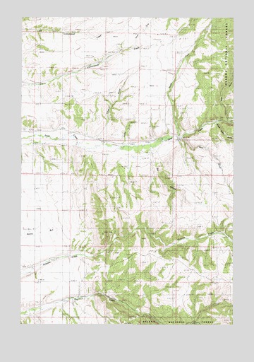
Lippert Gulch, MT USGS Topographic Map
Click on map above to begin viewing in our Map Viewer.

This topographic map contains these locations and features:
Feature Name Type Latitude Longitude GNIS ID View Map
06N03E04AC__01 WellWellN46.3055°W111.3547°815287View Map
06N03E04BC__01 WellWellN46.3055°W111.3652°815288View Map
06N03E05DD__01 WellWellN46.2983°W111.3705°815210View Map
06N03E08AD__01 WellWellN46.2910°W111.3705°815131View Map
06N03E09BB__01 WellWellN46.2947°W111.3652°815163View Map
06N03E17DA__01 WellWellN46.2730°W111.3705°814984View Map
07N03E14AD__01 WellWellN46.3635°W111.3088°815751View Map
07N03E14AD__02 WellWellN46.3635°W111.3088°815752View Map
07N03E14BD__01 WellWellN46.3635°W111.3191°815753View Map
07N03E14BD__02 WellWellN46.3635°W111.3191°815754View Map
07N03E14BD__03 WellWellN46.3635°W111.3191°815755View Map
07N03E14DD__01 WellWellN46.3563°W111.3088°815688View Map
07N03E15DD__01 WellWellN46.3563°W111.3297°815689View Map
07N03E15DD__02 WellWellN46.3563°W111.3297°815690View Map
07N03E24AB__01 WellWellN46.3530°W111.2933°815657View Map
07N03E25DABB01 WellWellN46.3308°W111.2905°815509View Map
07N03E28CC__01 WellWellN46.3277°W111.3658°815487View Map
07N03E28DB__01 WellWellN46.3313°W111.3555°815513View Map
07N03E28DC__01 WellWellN46.3277°W111.3555°815486View Map
07N03E32AA__01 WellWellN46.3241°W111.3711°815451View Map
07N03E32AA__02 WellWellN46.3241°W111.3711°815452View Map
07N03E33BA__01 WellWellN46.3241°W111.3608°815450View Map
07N03E34BA__01 WellWellN46.3241°W111.3400°815449View Map
Bear GulchValleyN46.3335°W111.2547°779538View Map
Black Butte GulchValleyN46.3324°W111.2602°779979View Map
Clark RanchLocaleN46.3566°W111.3305°781325View Map
Cottonwood School (historical)SchoolN46.3669°W111.2847°781743View Map
Deep Creek PavillionLocaleN46.3244°W111.2833°782215View Map
Deep Creek Ranger StationLocaleN46.3330°W111.2619°782218View Map
Dry Creek SchoolSchoolN46.2566°W111.3708°800711View Map
Dry HollowValleyN46.3149°W111.2975°806260View Map
East Glenwood School (historical)SchoolN46.3055°W111.2630°782931View Map
Flume HollowValleyN46.3241°W111.3158°806261View Map
Goodwin RanchLocaleN46.3652°W111.2936°784102View Map
Kieckbusch HomesteadLocaleN46.3549°W111.3072°785723View Map
Kieckbusch RanchLocaleN46.3235°W111.3413°785724View Map
Lippert GulchValleyN46.3260°W111.3322°786213View Map
North Fork Cottonwood CreekStreamN46.3630°W111.3091°794778View Map
North Fork Deep CreekStreamN46.3252°W111.2827°788132View Map
Ross GulchValleyN46.3252°W111.2808°789789View Map
Upper Deep Creek School (historical)SchoolN46.3280°W111.3639°792624View Map
Walter RanchLocaleN46.3619°W111.3166°792786View Map
Williams RanchLocaleN46.2780°W111.3477°793332View Map

Note: Coordinates in the location and feature list above are referenced to NAD83 datum.


Copyright (C) 2008-2025 Ryan Niemi / Sunset Dynamics ... All Rights Reserved