TopoQuest Logo
Do you find TopoQuest useful?
Help keep TopoQuest running and adding new maps/features by donating!
Bitcoin:  19c7KJd3qBynnjoSw5npx9KScwjBe4ifkT
Litecoin:  LXs6TkuXGGXo1vDsWCkWVdjQX94eUKd6ui
Home View Maps Find Maps Find Places Resources & Links


Tracy East, Minnesota Topographic Map

USGS Map Title: Tracy East, MN
USGS Map MRC: 44095B5
DRG (GeoTIFF) Download: o44095b5.tif


Neighboring USGS Topographic Map Quads:


  Amiret, MN  
44095C6
 

  Milroy SE, MN  
44095C5
 

  Wabasso SW, MN  
44095C4
 

  Tracy West, MN  
44095B6
 

  Tracy East, MN  
44095B5
 

  Walnut Grove, MN  
44095B4
 

  Currie, MN  
44095A6
 

  Dovray, MN  
44095A5
 

  Westbrook, MN  
44095A4


Map MRC Location:

N45°
W96°
N45°
W95°
H8 H7 H6 H5 H4 H3 H2 H1
G8 G7 G6 G5 G4 G3 G2 G1
F8 F7 F6 F5 F4 F3 F2 F1
E8 E7 E6 E5 E4 E3 E2 E1
D8 D7 D6 D5 D4 D3 D2 D1
C8 C7 C6 C5 C4 C3 C2 C1
B8 B7 B6 B5 B4 B3 B2 B1
A8 A7 A6 A5 A4 A3 A2 A1
N44°
W96°
N44°
W95°

Tracy East, MN USGS 1:24K Topographic Map Preview:
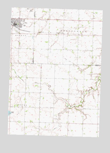
Tracy East, MN USGS Topographic Map
Click on map above to begin viewing in our Map Viewer.

This topographic map contains these locations and features:
Feature Name Type Latitude Longitude GNIS ID View Map
Cedar Lane Trailer ParkPopulated PlaceN44.2292°W95.6244°2064251View Map
Christian Alliance ChurchChurchN44.2358°W95.6247°2064256View Map
Church of ChristChurchN44.2331°W95.6153°2064260View Map
City of TracyCivilN44.2376°W95.6161°2397044View Map
East Side ParkParkN44.2361°W95.6111°2064247View Map
First Presbyterian ChurchChurchN44.2344°W95.6194°2064257View Map
Holly ChurchChurchN44.1525°W95.5231°645097View Map
Judicial Ditch Number TwentyeightCanalN44.1980°W95.5411°645874View Map
Lions Wayside ParkParkN44.2394°W95.6056°2064244View Map
Phil Draayum Pond DamDamN44.2133°W95.5686°1777226View Map
Saint Mary's Catholic ChurchChurchN44.2361°W95.6231°2064262View Map
Saint Mary's Catholic SchoolSchoolN44.2356°W95.6236°2064266View Map
Sanford Tracy Medical CenterHospitalN44.2323°W95.6073°2064265View Map
Township of HollyCivilN44.1522°W95.5224°664501View Map
Township of SpringdaleCivilN44.2394°W95.5336°665669View Map
TracyLocaleN44.2319°W95.6228°2064250View Map
TracyPopulated PlaceN44.2333°W95.6192°653262View Map
Tracy AmbulanceBuildingN44.2302°W95.6142°2721373View Map
Tracy CemeteryCemeteryN44.2130°W95.6127°653263View Map
Tracy City ParkParkN44.2336°W95.6158°2064246View Map
Tracy Country ClubLocaleN44.2380°W95.5767°659961View Map
Tracy Fire DepartmentBuildingN44.2331°W95.6180°2666345View Map
Tracy Grade SchoolSchoolN44.2250°W95.6128°2064252View Map
Tracy Lutheran ChurchChurchN44.2331°W95.6144°2064259View Map
Tracy Medical ClinicHospitalN44.2322°W95.6064°2064264View Map
Tracy Municipal AirportAirportN44.2494°W95.6114°660443View Map
Tracy Nursing HomeHospitalN44.2356°W95.6153°2064263View Map
Tracy Police DepartmentBuildingN44.2337°W95.6197°2064254View Map
Tracy Post OfficePost OfficeN44.2325°W95.6194°2064309View Map
Tracy Public LibraryBuildingN44.2328°W95.6200°2064253View Map
Tracy United Methodist ChurchChurchN44.2325°W95.6167°2064261View Map
Travelers ParkParkN44.2381°W95.6142°2064249View Map
Werner ParkParkN44.2347°W95.6089°2064248View Map
Willow CreekStreamN44.1555°W95.5442°654188View Map
Zion Lutheran ChurchChurchN44.2361°W95.6153°2064258View Map

Note: Coordinates in the location and feature list above are referenced to NAD83 datum.


Copyright (C) 2008-2025 Ryan Niemi / Sunset Dynamics ... All Rights Reserved