TopoQuest Logo
Do you find TopoQuest useful?
Help keep TopoQuest running and adding new maps/features by donating!
Bitcoin:  19c7KJd3qBynnjoSw5npx9KScwjBe4ifkT
Litecoin:  LXs6TkuXGGXo1vDsWCkWVdjQX94eUKd6ui
Home View Maps Find Maps Find Places Resources & Links


Tracy West, Minnesota Topographic Map

USGS Map Title: Tracy West, MN
USGS Map MRC: 44095B6
DRG (GeoTIFF) Download: o44095b6.tif


Neighboring USGS Topographic Map Quads:


  Marshall SE, MN  
44095C7
 

  Amiret, MN  
44095C6
 

  Milroy SE, MN  
44095C5
 

  Balaton, MN  
44095B7
 

  Tracy West, MN  
44095B6
 

  Tracy East, MN  
44095B5
 

  Hadley, MN  
44095A7
 

  Currie, MN  
44095A6
 

  Dovray, MN  
44095A5


Map MRC Location:

N45°
W96°
N45°
W95°
H8 H7 H6 H5 H4 H3 H2 H1
G8 G7 G6 G5 G4 G3 G2 G1
F8 F7 F6 F5 F4 F3 F2 F1
E8 E7 E6 E5 E4 E3 E2 E1
D8 D7 D6 D5 D4 D3 D2 D1
C8 C7 C6 C5 C4 C3 C2 C1
B8 B7 B6 B5 B4 B3 B2 B1
A8 A7 A6 A5 A4 A3 A2 A1
N44°
W96°
N44°
W95°

Tracy West, MN USGS 1:24K Topographic Map Preview:
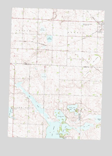
Tracy West, MN USGS Topographic Map
Click on map above to begin viewing in our Map Viewer.

This topographic map contains these locations and features:
Feature Name Type Latitude Longitude GNIS ID View Map
Bloody LakeLakeN44.1298°W95.6674°640272View Map
Clear LakeSwampN44.1850°W95.7042°641297View Map
Fox LakeLakeN44.1377°W95.6445°643860View Map
Fremont LakeLakeN44.1471°W95.6811°643930View Map
Greenhead State Wildlife Management AreaParkN44.2352°W95.6556°644441View Map
Hoiland CemeteryCemeteryN44.2106°W95.7045°645082View Map
Jim LakebedFlatN44.1880°W95.6478°645653View Map
Judicial Ditch Number Twenty ACanalN44.1905°W95.6286°645851View Map
KARL-FM (Tracy)TowerN44.2327°W95.6628°663354View Map
Kass-Morgan Group Farm Pond DamDamN44.2383°W95.6886°1777223View Map
Kingdom Hall of Jehovah's WitnessesChurchN44.2375°W95.6283°2064255View Map
North Twin LakeLakeN44.2296°W95.7082°648704View Map
OwankaPopulated PlaceN44.1261°W95.6758°654866View Map
Owanka Post Office (historical)Post OfficeN44.1261°W95.6758°2049971View Map
Rialson CemeteryCemeteryN44.2245°W95.6536°649961View Map
Robbins SloughLakeN44.1453°W95.6284°650163View Map
Round LakeLakeN44.1553°W95.6644°650322View Map
Shetek State Wildlife Management AreaParkN44.1452°W95.6547°651973View Map
Sigel LakebedFlatN44.2022°W95.6361°652015View Map
South Twin LakeLakeN44.2212°W95.6978°652349View Map
Southwest PlaygroundParkN44.2278°W95.6300°2064245View Map
The InletBayN44.1597°W95.7164°653109View Map
The LakesPopulated PlaceN44.1383°W95.6653°1852585View Map
Township of MonroeCivilN44.2393°W95.6564°665009View Map
Township of ShetekCivilN44.1524°W95.6422°665596View Map
Tracy Senior High SchoolSchoolN44.2250°W95.6306°2064267View Map

Note: Coordinates in the location and feature list above are referenced to NAD83 datum.


Copyright (C) 2008-2025 Ryan Niemi / Sunset Dynamics ... All Rights Reserved