TopoQuest Logo
Do you find TopoQuest useful?
Help keep TopoQuest running and adding new maps/features by donating!
Bitcoin:  19c7KJd3qBynnjoSw5npx9KScwjBe4ifkT
Litecoin:  LXs6TkuXGGXo1vDsWCkWVdjQX94eUKd6ui
Home View Maps Find Maps Find Places Resources & Links


Trego, Wisconsin Topographic Map

USGS Map Title: Trego, WI
USGS Map MRC: 45091H7
DRG (GeoTIFF) Download: o45091h7.tif


Neighboring USGS Topographic Map Quads:


  Horseshoe Lake, WI  
46091A8
 

  Minong, WI  
46091A7
 

  Stanberry West, WI  
46091A6
 

  Dunn Lake, WI  
45091H8
 

  Trego, WI  
45091H7
 

  Springbrook, WI  
45091H6
 

  Spooner, WI  
45091G8
 

  Spooner Lake, WI  
45091G7
 

  Potato Lake, WI  
45091G6


Map MRC Location:

N46°
W92°
N46°
W91°
H8 H7 H6 H5 H4 H3 H2 H1
G8 G7 G6 G5 G4 G3 G2 G1
F8 F7 F6 F5 F4 F3 F2 F1
E8 E7 E6 E5 E4 E3 E2 E1
D8 D7 D6 D5 D4 D3 D2 D1
C8 C7 C6 C5 C4 C3 C2 C1
B8 B7 B6 B5 B4 B3 B2 B1
A8 A7 A6 A5 A4 A3 A2 A1
N45°
W92°
N45°
W91°

Trego, WI USGS 1:24K Topographic Map Preview:
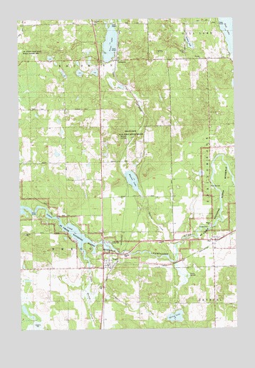
Trego, WI USGS Topographic Map
Click on map above to begin viewing in our Map Viewer.

This topographic map contains these locations and features:
Feature Name Type Latitude Longitude GNIS ID View Map
Brooklyn TownhallBuildingN45.9830°W91.8260°1833829View Map
EarlPopulated PlaceN45.9105°W91.7605°1564266View Map
Earl Census Designated PlaceCensusN45.9124°W91.7674°2586481View Map
Earl SpringsSpringN45.9322°W91.7655°1564267View Map
Gardner LakeLakeN45.9901°W91.7757°1565408View Map
Gull LakeLakeN45.9955°W91.7523°1565939View Map
LampsonPopulated PlaceN45.9830°W91.8163°1567822View Map
Lampson CemeteryCemeteryN45.9985°W91.8311°1833850View Map
Lampson Lookout TowerTowerN45.9852°W91.8010°1581257View Map
Lampson Moraine Pines State Natural AreaParkN45.9728°W91.8672°2082078View Map
Little Mackay CreekStreamN45.9069°W91.8374°1568309View Map
Potato CreekStreamN45.8897°W91.8332°1571827View Map
Silver LakeLakeN45.9900°W91.8216°1574148View Map
Spring LakeLakeN45.8798°W91.7857°1574677View Map
Spring LakeReservoirN45.8849°W91.7835°1792631View Map
Spring Lake 3WR34 DamDamN45.8849°W91.7835°1792630View Map
Town of TregoCivilN45.9171°W91.8504°1584289View Map
TregoPopulated PlaceN45.8997°W91.8210°1575585View Map
Trego Census Designated PlaceCensusN45.9049°W91.8287°2586561View Map
Trego Lake County ParkParkN45.9113°W91.8255°1575588View Map
Veazie SpringsSpringN45.8953°W91.7781°1576052View Map
Washburn CountyCivilN45.8992°W91.7912°1581124View Map
Wesleyan ChurchChurchN45.9838°W91.7696°1833892View Map
Whalen CreekStreamN45.9049°W91.7846°1576595View Map
Whalen Creek State Public Hunting GroundsParkN45.9541°W91.8105°1833895View Map
Whalen LakeLakeN45.9349°W91.8098°1576596View Map
Whalen SpringsSpringN45.9525°W91.8127°1576597View Map

Note: Coordinates in the location and feature list above are referenced to NAD83 datum.


Copyright (C) 2008-2025 Ryan Niemi / Sunset Dynamics ... All Rights Reserved