TopoQuest Logo
Do you find TopoQuest useful?
Help keep TopoQuest running and adding new maps/features by donating!
Bitcoin:  19c7KJd3qBynnjoSw5npx9KScwjBe4ifkT
Litecoin:  LXs6TkuXGGXo1vDsWCkWVdjQX94eUKd6ui
Home View Maps Find Maps Find Places Resources & Links


Trenton, Louisiana Topographic Map

USGS Map Title: Trenton, LA
USGS Map MRC: 31093H6
DRG (GeoTIFF) Download: o31093h6.tif


Neighboring USGS Topographic Map Quads:


  Grand Cane, LA  
32093A7
 

  Mansfield, LA  
32093A6
 

  Bayou Pierre Lake, LA  
32093A5
 

  Hunter, LA  
31093H7
 

  Trenton, LA  
31093H6
 

  Pelican, LA  
31093H5
 

  Union Springs, LA  
31093G7
 

  Converse, LA  
31093G6
 

  Pleasant Hill, LA  
31093G5


Map MRC Location:

N32°
W94°
N32°
W93°
H8 H7 H6 H5 H4 H3 H2 H1
G8 G7 G6 G5 G4 G3 G2 G1
F8 F7 F6 F5 F4 F3 F2 F1
E8 E7 E6 E5 E4 E3 E2 E1
D8 D7 D6 D5 D4 D3 D2 D1
C8 C7 C6 C5 C4 C3 C2 C1
B8 B7 B6 B5 B4 B3 B2 B1
A8 A7 A6 A5 A4 A3 A2 A1
N31°
W94°
N31°
W93°

Trenton, LA USGS 1:24K Topographic Map Preview:
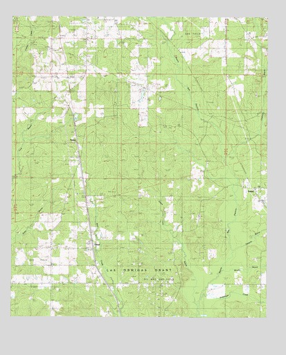
Trenton, LA USGS Topographic Map
Click on map above to begin viewing in our Map Viewer.

This topographic map contains these locations and features:
Feature Name Type Latitude Longitude GNIS ID View Map
Brushy BayouStreamN31.8952°W93.6471°533459View Map
CatunaPopulated PlaceN31.9038°W93.7107°541067View Map
Chatman BayouStreamN31.9418°W93.6474°533887View Map
Chatman Bayou Oil and Gas FieldOilfieldN31.9932°W93.6624°545597View Map
CokerPopulated PlaceN31.9835°W93.7138°545601View Map
East Spider Gas FieldOilfieldN31.9974°W93.7057°545615View Map
Eudora (historical)Populated PlaceN31.9854°W93.6680°545621View Map
Flanagan CemeteryCemeteryN31.9974°W93.6871°534976View Map
Green Cane BayouStreamN31.8816°W93.6605°535378View Map
Guy CemeteryCemeteryN31.9724°W93.6802°535469View Map
Halcyon (historical)Populated PlaceN31.9402°W93.7168°545629View Map
Mount Olive Baptist ChurchChurchN31.9660°W93.6841°555401View Map
OxfordPopulated PlaceN31.9235°W93.6280°555576View Map
Oxford Post OfficePost OfficeN31.9288°W93.6310°1630267View Map
Parish Governing Authority District 4DCivilN31.9101°W93.7449°1930057View Map
Rising Star ChurchChurchN31.9316°W93.6382°538615View Map
Saint Josephs ChurchChurchN31.9032°W93.7310°538925View Map
Shiloh Baptist ChurchChurchN31.9757°W93.6460°556026View Map
Springhill Baptist ChurchChurchN31.9174°W93.6577°556119View Map
Stephenson CemeteryCemeteryN31.9804°W93.7252°539657View Map
Stinkfinger CreekStreamN31.8793°W93.6577°539673View Map
Tenmile BayouStreamN31.9021°W93.6424°556215View Map
TrentonPopulated PlaceN31.9502°W93.7193°543734View Map
Trenton Gas FieldOilfieldN31.9618°W93.6793°545668View Map
Williams CemeteryCemeteryN31.9549°W93.6732°540429View Map

Note: Coordinates in the location and feature list above are referenced to NAD83 datum.


Copyright (C) 2008-2025 Ryan Niemi / Sunset Dynamics ... All Rights Reserved