TopoQuest Logo
Do you find TopoQuest useful?
Help keep TopoQuest running and adding new maps/features by donating!
Bitcoin:  19c7KJd3qBynnjoSw5npx9KScwjBe4ifkT
Litecoin:  LXs6TkuXGGXo1vDsWCkWVdjQX94eUKd6ui
Home View Maps Find Maps Find Places Resources & Links


Bayou Pierre Lake, Louisiana Topographic Map

USGS Map Title: Bayou Pierre Lake, LA
USGS Map MRC: 32093A5
DRG (GeoTIFF) Download: o32093a5.tif


Neighboring USGS Topographic Map Quads:


  Holly, LA  
32093B6
 

  Clear Lake, LA  
32093B5
 

  East Point, LA  
32093B4
 

  Mansfield, LA  
32093A6
 

  Bayou Pierre Lake, LA  
32093A5
 

  Harmon, LA  
32093A4
 

  Trenton, LA  
31093H6
 

  Pelican, LA  
31093H5
 

  Evelyn, LA  
31093H4


Map MRC Location:

N33°
W94°
N33°
W93°
H8 H7 H6 H5 H4 H3 H2 H1
G8 G7 G6 G5 G4 G3 G2 G1
F8 F7 F6 F5 F4 F3 F2 F1
E8 E7 E6 E5 E4 E3 E2 E1
D8 D7 D6 D5 D4 D3 D2 D1
C8 C7 C6 C5 C4 C3 C2 C1
B8 B7 B6 B5 B4 B3 B2 B1
A8 A7 A6 A5 A4 A3 A2 A1
N32°
W94°
N32°
W93°

Bayou Pierre Lake, LA USGS 1:24K Topographic Map Preview:
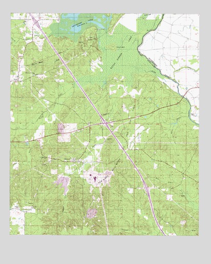
Bayou Pierre Lake, LA USGS Topographic Map
Click on map above to begin viewing in our Map Viewer.

This topographic map contains these locations and features:
Feature Name Type Latitude Longitude GNIS ID View Map
Bailey BayouStreamN32.0671°W93.5068°532276View Map
Bayou LoupStreamN32.1085°W93.5810°553485View Map
Bayou Pierre LakeSwampN32.1018°W93.5507°543874View Map
Bethlehem CemeteryCemeteryN32.0527°W93.5605°532987View Map
Buffalo BayouStreamN32.0899°W93.5649°533516View Map
CarmelPopulated PlaceN32.0874°W93.6207°553897View Map
Carmel SchoolLocaleN32.0918°W93.6021°533768View Map
Chicot IslandIslandN32.1071°W93.5571°533911View Map
Clifton BayouStreamN32.0666°W93.6041°534003View Map
Coon BranchStreamN32.1085°W93.6230°554075View Map
Dill CemeteryCemeteryN32.1103°W93.5707°534527View Map
GossPopulated PlaceN32.0613°W93.5580°543249View Map
Immaculate Conception ChurchChurchN32.0888°W93.6096°543853View Map
Immaculate Conception ChurchChurchN32.0904°W93.6093°541310View Map
Mount Carmel ChurchChurchN32.0485°W93.5380°537309View Map
Mundy BayouStreamN32.0810°W93.5460°555443View Map
Mundy BayouGutN32.0846°W93.5218°537493View Map
Mundy ChurchChurchN32.0629°W93.5727°537494View Map
NabortonPopulated PlaceN32.0418°W93.5832°543505View Map
Paps HillSummitN32.0696°W93.5018°537963View Map
Parish Governing Authority District 4CCivilN32.0095°W93.6213°1930056View Map
Red River - Bull Bayou Oil and Gas FieldOilfieldN32.0657°W93.5588°555771View Map
Rock ChapelChurchN32.0963°W93.6093°541311View Map
Sampson ChannelChannelN32.1215°W93.5505°539119View Map
Sampson ChannelGutN32.1196°W93.5516°545661View Map
Sawlog Lake (historical)LakeN32.1210°W93.5182°549530View Map
Sawmill CreekStreamN32.0349°W93.5830°539199View Map
Siphorien BayouStreamN32.1129°W93.5980°556054View Map
Smithport DamDamN32.1157°W93.5663°556730View Map
Smithport LakeReservoirN32.1104°W93.5667°556070View Map
Truevine CemeteryCemeteryN32.0157°W93.6188°540007View Map
Truevine ChurchChurchN32.0157°W93.6102°540008View Map
Ward FiveCivilN32.0532°W93.5674°544999View Map
Willow LakeLakeN32.1235°W93.5360°556440View Map
Woodvine CemeteryCemeteryN32.0435°W93.6013°540535View Map

Note: Coordinates in the location and feature list above are referenced to NAD83 datum.


Copyright (C) 2008-2025 Ryan Niemi / Sunset Dynamics ... All Rights Reserved