TopoQuest Logo
Do you find TopoQuest useful?
Help keep TopoQuest running and adding new maps/features by donating!
Bitcoin:  19c7KJd3qBynnjoSw5npx9KScwjBe4ifkT
Litecoin:  LXs6TkuXGGXo1vDsWCkWVdjQX94eUKd6ui
Home View Maps Find Maps Find Places Resources & Links


Grand Cane, Louisiana Topographic Map

USGS Map Title: Grand Cane, LA
USGS Map MRC: 32093A7
DRG (GeoTIFF) Download: o32093a7.tif


Neighboring USGS Topographic Map Quads:


  Keatchie, LA  
32093B8
 

  Gloster, LA  
32093B7
 

  Holly, LA  
32093B6
 

  Longstreet, LA  
32093A8
 

  Grand Cane, LA  
32093A7
 

  Mansfield, LA  
32093A6
 

  Logansport East, LA  
31093H8
 

  Hunter, LA  
31093H7
 

  Trenton, LA  
31093H6


Map MRC Location:

N33°
W94°
N33°
W93°
H8 H7 H6 H5 H4 H3 H2 H1
G8 G7 G6 G5 G4 G3 G2 G1
F8 F7 F6 F5 F4 F3 F2 F1
E8 E7 E6 E5 E4 E3 E2 E1
D8 D7 D6 D5 D4 D3 D2 D1
C8 C7 C6 C5 C4 C3 C2 C1
B8 B7 B6 B5 B4 B3 B2 B1
A8 A7 A6 A5 A4 A3 A2 A1
N32°
W94°
N32°
W93°

Grand Cane, LA USGS 1:24K Topographic Map Preview:
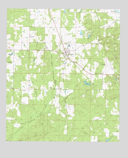
Grand Cane, LA USGS Topographic Map
Click on map above to begin viewing in our Map Viewer.

This topographic map contains these locations and features:
Feature Name Type Latitude Longitude GNIS ID View Map
Bagley PondReservoirN32.0825°W93.8693°553337View Map
Buck BranchStreamN32.0241°W93.8438°533493View Map
C E 'Rusty' Williams AirportAirportN32.0678°W93.7648°1632841View Map
Canadian Bayou Oil and Gas FieldOilfieldN32.0732°W93.8716°533679View Map
Central School CorporationSchoolN32.0837°W93.8055°545596View Map
Charlie Hunter Pond DamDamN32.0018°W93.7619°556995View Map
Cook CemeteryCemeteryN32.0129°W93.8243°534093View Map
Cook CreekStreamN32.0724°W93.8249°534095View Map
Dance Pond DamDamN32.0968°W93.7902°557003View Map
Eatman Estate DamDamN32.1002°W93.7918°556996View Map
Friendship Baptist ChurchChurchN32.0435°W93.8188°554488View Map
Friendship CemeteryCemeteryN32.0504°W93.8246°535114View Map
Grand CanePopulated PlaceN32.0841°W93.8102°554570View Map
Grand Cane Oil FieldOilfieldN32.0485°W93.8160°554571View Map
Lowery Pond DamDamN32.1218°W93.7885°557002View Map
Mansfield Army Air Field (historical)MilitaryN32.0722°W93.7625°2085458View Map
Mary Evergreen Baptist ChurchChurchN32.0641°W93.7774°555244View Map
North Grand Cane Oil and Gas FieldOilfieldN32.0974°W93.8482°537732View Map
Old Zion Baptist ChurchChurchN32.0854°W93.8416°555559View Map
Parish Governing Authority District 4BCivilN32.0666°W93.7638°1930054View Map
Rogers PondReservoirN32.1211°W93.7522°555827View Map
Rogers Pond DamDamN32.1218°W93.7513°556997View Map
Southerland BottomBendN32.0146°W93.8555°539518View Map
Stevenson Pond DamDamN32.1185°W93.8085°557001View Map
Union Mission ChurchChurchN32.0482°W93.8544°540108View Map
Village of Grand CaneCivilN32.0836°W93.8088°2407468View Map
Wallace CreekStreamN32.0254°W93.8357°540211View Map
Zion Hill Baptist Church Number 1ChurchN32.0921°W93.7741°556500View Map
Zion Hill CemeteryCemeteryN32.0960°W93.7732°540597View Map

Note: Coordinates in the location and feature list above are referenced to NAD83 datum.


Copyright (C) 2008-2025 Ryan Niemi / Sunset Dynamics ... All Rights Reserved