TopoQuest Logo
Do you find TopoQuest useful?
Help keep TopoQuest running and adding new maps/features by donating!
Bitcoin:  19c7KJd3qBynnjoSw5npx9KScwjBe4ifkT
Litecoin:  LXs6TkuXGGXo1vDsWCkWVdjQX94eUKd6ui
Home View Maps Find Maps Find Places Resources & Links


Trimont, Minnesota Topographic Map

USGS Map Title: Trimont, MN
USGS Map MRC: 43094G6
DRG (GeoTIFF) Download: o43094g6.tif


Neighboring USGS Topographic Map Quads:


  Butterfield, MN  
43094H7
 

  Saint James West, MN  
43094H6
 

  Saint James East, MN  
43094H5
 

  Mountain Lake SE, MN  
43094G7
 

  Trimont, MN  
43094G6
 

  Saint James SE, MN  
43094G5
 

  Alpha, MN  
43094F7
 

  Sherburn, MN  
43094F6
 

  Welcome, MN  
43094F5


Map MRC Location:

N44°
W95°
N44°
W94°
H8 H7 H6 H5 H4 H3 H2 H1
G8 G7 G6 G5 G4 G3 G2 G1
F8 F7 F6 F5 F4 F3 F2 F1
E8 E7 E6 E5 E4 E3 E2 E1
D8 D7 D6 D5 D4 D3 D2 D1
C8 C7 C6 C5 C4 C3 C2 C1
B8 B7 B6 B5 B4 B3 B2 B1
A8 A7 A6 A5 A4 A3 A2 A1
N43°
W95°
N43°
W94°

Trimont, MN USGS 1:24K Topographic Map Preview:
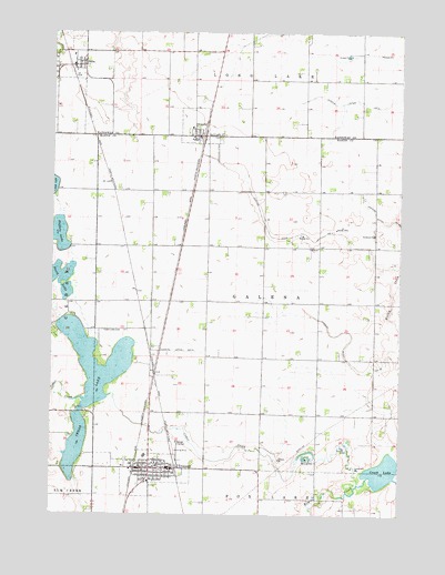
Trimont, MN USGS Topographic Map
Click on map above to begin viewing in our Map Viewer.

This topographic map contains these locations and features:
Feature Name Type Latitude Longitude GNIS ID View Map
Buffalo LakeLakeN43.8226°W94.7474°640615View Map
Cedar CreekStreamN43.7583°W94.6383°640996View Map
Cedar LakeLakeN43.7899°W94.7340°641006View Map
Cedar Lake CemeteryCemeteryN43.7977°W94.7319°641026View Map
City of OdinCivilN43.8673°W94.7428°2395300View Map
City of OrmsbyCivilN43.8504°W94.6986°2396080View Map
City of TrimontCivilN43.7610°W94.7162°2397054View Map
Creek LakeLakeN43.7613°W94.6305°642436View Map
Evangelical Covenant ChurchChurchN43.7622°W94.7130°2049470View Map
First Lutheran ChurchChurchN43.7633°W94.7130°2049471View Map
Immanuel ChurchChurchN43.8227°W94.6344°645368View Map
Judicial Ditch Number EightytwoCanalN43.8261°W94.6314°645995View Map
Judicial Ditch Number FourCanalN43.8225°W94.6714°645920View Map
Judicial Ditch Number ThirtynineCanalN43.7883°W94.6405°645917View Map
Judicial Ditch Number TwentyoneCanalN43.7927°W94.7064°645852View Map
Judicial Ditch Number TwoCanalN43.8586°W94.6275°645839View Map
Methodist ChurchChurchN43.7633°W94.7125°2049472View Map
Mountain County West Junior High SchoolSchoolN43.7652°W94.7166°2049475View Map
North LakeLakeN43.8118°W94.7489°648663View Map
OdinPopulated PlaceN43.8663°W94.7428°648898View Map
Odin (historical)LocaleN43.8666°W94.7447°2050936View Map
Odin Fire DepartmentBuildingN43.8669°W94.7431°2666514View Map
Odin LibraryBuildingN43.8663°W94.7428°2050933View Map
Odin Post OfficePost OfficeN43.8666°W94.7430°2050931View Map
Odin Town HallBuildingN43.8663°W94.7428°2050935View Map
OrmsbyPopulated PlaceN43.8483°W94.6978°648995View Map
Ormsby (historical)LocaleN43.8483°W94.6975°2069191View Map
Ormsby Fire DepartmentBuildingN43.8489°W94.6983°2666519View Map
Ormsby Post OfficePost OfficeN43.8483°W94.6975°2069192View Map
Saint Olaf Lutheran ChurchChurchN43.8663°W94.7428°2050932View Map
Township of GalenaCivilN43.8052°W94.6739°664240View Map
TrimontPopulated PlaceN43.7622°W94.7072°653277View Map
Trimont City LibraryBuildingN43.7616°W94.7175°2049464View Map
Trimont Family Practice ClinicHospitalN43.7591°W94.7141°2049466View Map
Trimont Fire Department and Ambulance ServiceBuildingN43.7623°W94.7176°2049462View Map
Trimont Health Care CenterHospitalN43.7586°W94.7150°2049467View Map
Trimont Nursing HomeHospitalN43.7586°W94.7150°2049468View Map
Trimont Police DepartmentBuildingN43.7623°W94.7183°2049463View Map
Trimont Post OfficePost OfficeN43.7622°W94.7144°2049465View Map
Trinity Lutheran ChurchChurchN43.7622°W94.7153°2049469View Map
Triumph Post Office (historical)Post OfficeN43.7622°W94.7072°2049403View Map
Zion Lutheran ChurchChurchN43.8663°W94.7428°2050934View Map

Note: Coordinates in the location and feature list above are referenced to NAD83 datum.


Copyright (C) 2008-2025 Ryan Niemi / Sunset Dynamics ... All Rights Reserved