TopoQuest Logo
Do you find TopoQuest useful?
Help keep TopoQuest running and adding new maps/features by donating!
Bitcoin:  19c7KJd3qBynnjoSw5npx9KScwjBe4ifkT
Litecoin:  LXs6TkuXGGXo1vDsWCkWVdjQX94eUKd6ui
Home View Maps Find Maps Find Places Resources & Links


Butterfield, Minnesota Topographic Map

USGS Map Title: Butterfield, MN
USGS Map MRC: 43094H7
DRG (GeoTIFF) Download: o43094h7.tif


Neighboring USGS Topographic Map Quads:


  Comfrey, MN  
44094A8
 

  Darfur, MN  
44094A7
 

  Godahl, MN  
44094A6
 

  Mountain Lake, MN  
43094H8
 

  Butterfield, MN  
43094H7
 

  Saint James West, MN  
43094H6
 

  Bergen, MN  
43094G8
 

  Mountain Lake SE, MN  
43094G7
 

  Trimont, MN  
43094G6


Map MRC Location:

N44°
W95°
N44°
W94°
H8 H7 H6 H5 H4 H3 H2 H1
G8 G7 G6 G5 G4 G3 G2 G1
F8 F7 F6 F5 F4 F3 F2 F1
E8 E7 E6 E5 E4 E3 E2 E1
D8 D7 D6 D5 D4 D3 D2 D1
C8 C7 C6 C5 C4 C3 C2 C1
B8 B7 B6 B5 B4 B3 B2 B1
A8 A7 A6 A5 A4 A3 A2 A1
N43°
W95°
N43°
W94°

Butterfield, MN USGS 1:24K Topographic Map Preview:
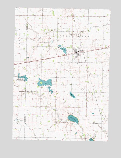
Butterfield, MN USGS Topographic Map
Click on map above to begin viewing in our Map Viewer.

This topographic map contains these locations and features:
Feature Name Type Latitude Longitude GNIS ID View Map
ButterfieldLocaleN43.9577°W94.7925°2050962View Map
ButterfieldPopulated PlaceN43.9583°W94.7947°640702View Map
Butterfield CemeteryCemeteryN43.9486°W94.7903°640703View Map
Butterfield City HallBuildingN43.9583°W94.7950°2050957View Map
Butterfield LakeLakeN43.9607°W94.8103°640706View Map
Butterfield LibraryBuildingN43.9583°W94.7950°2050959View Map
Butterfield Mennonite ChurchChurchN43.9605°W94.7966°2050963View Map
Butterfield Post Office (historical)Post OfficeN43.9583°W94.7950°2050958View Map
Butterfield Public SchoolSchoolN43.9597°W94.7914°2050965View Map
Butterfield Volunteer Fire DepartmentBuildingN43.9590°W94.7929°2666523View Map
City of ButterfieldCivilN43.9580°W94.7936°2393484View Map
First Lutheran ChurchChurchN43.9544°W94.7941°2050961View Map
Judicial Ditch Number OneCanalN43.9261°W94.8728°645766View Map
Mennonite CemeteryCemeteryN43.9752°W94.7983°647768View Map
Mud LakeLakeN43.9168°W94.7964°648212View Map
Regehr State Wildlife Management AreaParkN43.9330°W94.8630°649917View Map
Saint John Evangelical Lutheran ChurchChurchN43.8836°W94.8375°2050954View Map
Saint Matthew's Evangelical ChurchChurchN43.9780°W94.7905°2050964View Map
School LakeLakeN43.8958°W94.7968°651311View Map
Sulem LakeLakeN43.9292°W94.8345°652781View Map
Township of ButterfieldCivilN43.9784°W94.7991°663716View Map
Township of OdinCivilN43.8916°W94.7996°665200View Map
Voss ParkParkN43.9630°W94.8036°653688View Map
Voss Park CampgroundLocaleN43.9633°W94.8030°2050960View Map

Note: Coordinates in the location and feature list above are referenced to NAD83 datum.


Copyright (C) 2008-2024 Ryan Niemi / Sunset Dynamics ... All Rights Reserved