TopoQuest Logo
Do you find TopoQuest useful?
Help keep TopoQuest running and adding new maps/features by donating!
Bitcoin:  19c7KJd3qBynnjoSw5npx9KScwjBe4ifkT
Litecoin:  LXs6TkuXGGXo1vDsWCkWVdjQX94eUKd6ui
Home View Maps Find Maps Find Places Resources & Links


Trinity Center, California Topographic Map

USGS Map Title: Trinity Center, CA
USGS Map MRC: 40122H6
DRG (GeoTIFF) Download: o40122h6.tif


Neighboring USGS Topographic Map Quads:


  Ycatapom Peak, CA  
41122A7
 

  Carrville, CA  
41122A6
 

  Whisky Bill Peak, CA  
41122A5
 

  Covington Mill, CA  
40122H7
 

  Trinity Center, CA  
40122H6
 

  Damnation Peak, CA  
40122H5
 

  Trinity Dam, CA  
40122G7
 

  Papoose Creek, CA  
40122G6
 

  Schell Mountain, CA  
40122G5


Map MRC Location:

N41°
W123°
N41°
W122°
H8 H7 H6 H5 H4 H3 H2 H1
G8 G7 G6 G5 G4 G3 G2 G1
F8 F7 F6 F5 F4 F3 F2 F1
E8 E7 E6 E5 E4 E3 E2 E1
D8 D7 D6 D5 D4 D3 D2 D1
C8 C7 C6 C5 C4 C3 C2 C1
B8 B7 B6 B5 B4 B3 B2 B1
A8 A7 A6 A5 A4 A3 A2 A1
N40°
W123°
N40°
W122°

Trinity Center, CA USGS 1:24K Topographic Map Preview:
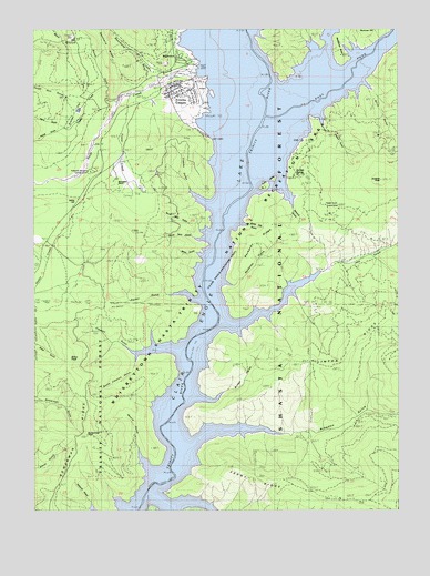
Trinity Center, CA USGS Topographic Map
Click on map above to begin viewing in our Map Viewer.

This topographic map contains these locations and features:
Feature Name Type Latitude Longitude GNIS ID View Map
Billie GulchValleyN40.9688°W122.6350°219292View Map
Billys PeakSummitN40.9154°W122.7403°219301View Map
Bowerman PeakSummitN40.8940°W122.7375°219714View Map
Bragdon (historical)Populated PlaceN40.8904°W122.6995°1683022View Map
Bragdon GulchValleyN40.8921°W122.6975°233543View Map
Bridge GulchValleyN40.9040°W122.6947°1665318View Map
Clawton GulchValleyN40.9165°W122.7056°221179View Map
Coffee DitchStreamN40.9743°W122.7406°275326View Map
Feeny GulchValleyN40.8768°W122.7036°223428View Map
Feeny RidgeRidgeN40.8824°W122.6672°223429View Map
Foster CreekStreamN40.9818°W122.7197°223725View Map
Freethy GulchValleyN40.9543°W122.6925°223943View Map
Gibson GulchValleyN40.9771°W122.6522°1665354View Map
Gratten CreekStreamN40.9851°W122.7275°224484View Map
Gratten FlatFlatN40.9776°W122.7370°224485View Map
Hay GulchValleyN40.9229°W122.6850°225044View Map
Irish IslesIslandN40.9596°W122.6706°1665372View Map
Jackass PeakSummitN40.9610°W122.6347°226060View Map
Jackass SpringSpringN40.9621°W122.6625°226064View Map
Jackass Spring CampgroundLocaleN40.9615°W122.6453°276928View Map
Linton RidgeRidgeN40.9113°W122.6495°227168View Map
Manzanita ButteSummitN40.9932°W122.6456°1665389View Map
Moore GulchValleyN40.8854°W122.7111°1665397View Map
Moss GulchValleyN40.9413°W122.6947°229122View Map
Nelson CreekStreamN40.9968°W122.6281°264045View Map
North Fork Swift CreekStreamN40.9813°W122.7236°234377View Map
North Twin GulchValleyN40.9476°W122.6939°229773View Map
Norwegian RanchLocaleN40.9640°W122.7195°229789View Map
Packer GulchValleyN40.9296°W122.6975°230218View Map
Pansy GulchValleyN40.9732°W122.7450°230292View Map
Parry GulchValleyN40.9751°W122.7420°230538View Map
Preacher Meadow CampgroundLocaleN40.9646°W122.7286°231031View Map
Rackerby GulchValleyN40.9338°W122.6872°231159View Map
Rackerby RidgeRidgeN40.9468°W122.6689°231160View Map
Rancheria CreekStreamN40.9876°W122.7053°231217View Map
Sawmill GulchValleyN40.9590°W122.6659°1665422View Map
Scott MuseumBuildingN40.9865°W122.6975°1683056View Map
South Clawton GulchValleyN40.9151°W122.7159°1665431View Map
South Twin GulchValleyN40.9449°W122.6939°235126View Map
Star CreekStreamN40.9949°W122.7322°235389View Map
Swift CreekStreamN40.9882°W122.7020°235904View Map
Tepee Gulch CampLocaleN40.9532°W122.6478°236120View Map
Tough Gus GulchValleyN40.9813°W122.7375°1665445View Map
Trinity CenterPopulated PlaceN40.9832°W122.6997°1665446View Map
Trinity Center AirportAirportN40.9867°W122.6946°1654063View Map
Trinity Center Boat Ramp and MarinaLocaleN40.9721°W122.6917°1683061View Map
Trinity Center Census Designated PlaceCensusN40.9841°W122.7083°2583167View Map
Trinity Center Elementary SchoolSchoolN40.9832°W122.7067°1683062View Map
Trinity Center Post OfficePost OfficeN40.9814°W122.7034°1683063View Map
Trinity Center Recreation Plus Boat Ramp MarinaLocaleN40.9704°W122.6909°276927View Map
Trinity Center Volunteer Fire DepartmentBuildingN40.9838°W122.7045°2622101View Map
Usher HillSummitN40.9557°W122.7342°1665453View Map
White Oak GulchValleyN40.9493°W122.6795°1665457View Map
WyntoonLocaleN40.9896°W122.7039°276926View Map

Note: Coordinates in the location and feature list above are referenced to NAD83 datum.


Copyright (C) 2008-2025 Ryan Niemi / Sunset Dynamics ... All Rights Reserved