TopoQuest Logo
Do you find TopoQuest useful?
Help keep TopoQuest running and adding new maps/features by donating!
Bitcoin:  19c7KJd3qBynnjoSw5npx9KScwjBe4ifkT
Litecoin:  LXs6TkuXGGXo1vDsWCkWVdjQX94eUKd6ui
Home View Maps Find Maps Find Places Resources & Links


Turner Hollow, Utah Topographic Map

USGS Map Title: Turner Hollow, UT
USGS Map MRC: 40111H3
DRG (GeoTIFF) Download: o40111h3.tif


Neighboring USGS Topographic Map Quads:


  Henefer, UT  
41111A4
 

  Heiners Creek, UT  
41111A3
 

  Castle Rock, UT  
41111A2
 

  Coalville, UT  
40111H4
 

  Turner Hollow, UT  
40111H3
 

  Upton, UT  
40111H2
 

  Wanship, UT  
40111G4
 

  Crandall Canyon, UT  
40111G3
 

  Hidden Lake, UT  
40111G2


Map MRC Location:

N41°
W112°
N41°
W111°
H8 H7 H6 H5 H4 H3 H2 H1
G8 G7 G6 G5 G4 G3 G2 G1
F8 F7 F6 F5 F4 F3 F2 F1
E8 E7 E6 E5 E4 E3 E2 E1
D8 D7 D6 D5 D4 D3 D2 D1
C8 C7 C6 C5 C4 C3 C2 C1
B8 B7 B6 B5 B4 B3 B2 B1
A8 A7 A6 A5 A4 A3 A2 A1
N40°
W112°
N40°
W111°

Turner Hollow, UT USGS 1:24K Topographic Map Preview:
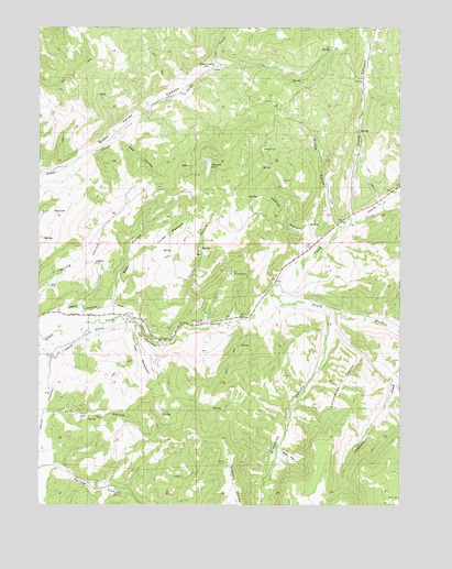
Turner Hollow, UT USGS Topographic Map
Click on map above to begin viewing in our Map Viewer.

This topographic map contains these locations and features:
Feature Name Type Latitude Longitude GNIS ID View Map
Bear HollowValleyN40.9705°W111.3483°1425351View Map
Big Robinson DitchCanalN40.9183°W111.3619°1425538View Map
Chappell LakeLakeN40.9648°W111.3176°1426535View Map
Chappell MineMineN40.9380°W111.3563°1426536View Map
Clark CanyonValleyN40.9516°W111.2671°1426658View Map
Cottonwood CanyonValleyN40.9141°W111.2632°1426905View Map
Deer PenBasinN40.8874°W111.2894°1427311View Map
Elkhorn CanyonValleyN40.9252°W111.2757°1427795View Map
Fewkes CanyonValleyN40.9441°W111.2794°1427911View Map
Grass CreekLocaleN40.9902°W111.3152°1428345View Map
Lodgepole CreekStreamN40.9249°W111.2719°1429849View Map
Middle CanyonValleyN40.9486°W111.2732°1430260View Map
North Narrows DitchCanalN40.9263°W111.3538°1430832View Map
Sage HollowValleyN40.9274°W111.3496°1432096View Map
South Fork Chalk CreekStreamN40.9299°W111.2946°1432675View Map
The MeadowsFlatN40.9133°W111.3407°1433361View Map
The NarrowsCliffN40.9184°W111.3392°1433369View Map
Turner HollowValleyN40.9224°W111.3232°1433707View Map
Turner MeadowsFlatN40.9458°W111.3305°1433708View Map
Weber MineMineN40.9322°W111.3721°1434026View Map

Note: Coordinates in the location and feature list above are referenced to NAD83 datum.


Copyright (C) 2008-2025 Ryan Niemi / Sunset Dynamics ... All Rights Reserved