TopoQuest Logo
Do you find TopoQuest useful?
Help keep TopoQuest running and adding new maps/features by donating!
Bitcoin:  19c7KJd3qBynnjoSw5npx9KScwjBe4ifkT
Litecoin:  LXs6TkuXGGXo1vDsWCkWVdjQX94eUKd6ui
Home View Maps Find Maps Find Places Resources & Links


Turtle Bay, Texas Topographic Map

USGS Map Title: Turtle Bay, TX
USGS Map MRC: 28096F3
DRG (GeoTIFF) Download: o28096f3.tif


Neighboring USGS Topographic Map Quads:


  La Ward, TX  
28096G4
 

  Francitas, TX  
28096G3
 

  Blessing, TX  
28096G2
 

  Olivia, TX  
28096F4
 

  Turtle Bay, TX  
28096F3
 

  Palacios, TX  
28096F2
 

  Keller Bay, TX  
28096E4
 

  Carancahua Pass, TX  
28096E3
 

  Palacios Point, TX  
28096E2


Map MRC Location:

N29°
W97°
N29°
W96°
H8 H7 H6 H5 H4 H3 H2 H1
G8 G7 G6 G5 G4 G3 G2 G1
F8 F7 F6 F5 F4 F3 F2 F1
E8 E7 E6 E5 E4 E3 E2 E1
D8 D7 D6 D5 D4 D3 D2 D1
C8 C7 C6 C5 C4 C3 C2 C1
B8 B7 B6 B5 B4 B3 B2 B1
A8 A7 A6 A5 A4 A3 A2 A1
N28°
W97°
N28°
W96°

Turtle Bay, TX USGS 1:24K Topographic Map Preview:
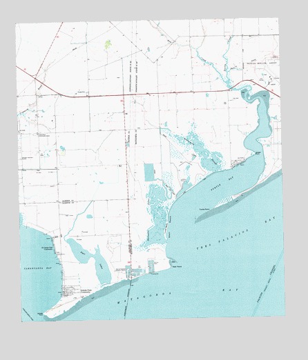
Turtle Bay, TX USGS Topographic Map
Click on map above to begin viewing in our Map Viewer.

This topographic map contains these locations and features:
Feature Name Type Latitude Longitude GNIS ID View Map
At Last MarinaLocaleN28.6356°W96.3564°2030490View Map
Buttermilk SloughStreamN28.6861°W96.2819°1353433View Map
Carancahua ChurchChurchN28.7042°W96.3652°1353809View Map
Carancahua PassChannelN28.6281°W96.3697°1353812View Map
City of PalaciosCivilN28.7302°W96.2511°2411354View Map
El Campo ClubLocaleN28.6564°W96.3586°1356862View Map
El Campo Club CommunityPopulated PlaceN28.6572°W96.3586°1377708View Map
Horn CreekStreamN28.7278°W96.2747°1359568View Map
Jensen PointCapeN28.6933°W96.2627°1377715View Map
Lund MotteCapeN28.6630°W96.3050°1361977View Map
Palacios Army Air Field (historical)MilitaryN28.7278°W96.2511°2093982View Map
Palacios Municipal AirportAirportN28.7244°W96.2538°1387281View Map
Reed CreekStreamN28.7228°W96.2747°1366299View Map
Sartwelle LakesLakeN28.6680°W96.3083°1367785View Map
Sartwelle Ranch Airport (historical)AirportN28.6850°W96.3252°1387280View Map
Schicke PointCapeN28.6306°W96.3577°1381064View Map
Schicke PointCapeN28.6278°W96.3664°1377719View Map
Schicke Point CommunityPopulated PlaceN28.6411°W96.3558°1377707View Map
Shell BeachBeachN28.6619°W96.3044°1368107View Map
Turtle BayBayN28.6819°W96.2766°1370305View Map
Turtle CreekStreamN28.7197°W96.2652°1370307View Map
Turtle PointCapeN28.6703°W96.2839°1370310View Map
Well PointCapeN28.6467°W96.3033°1371028View Map

Note: Coordinates in the location and feature list above are referenced to NAD83 datum.


Copyright (C) 2008-2025 Ryan Niemi / Sunset Dynamics ... All Rights Reserved