TopoQuest Logo
Do you find TopoQuest useful?
Help keep TopoQuest running and adding new maps/features by donating!
Bitcoin:  19c7KJd3qBynnjoSw5npx9KScwjBe4ifkT
Litecoin:  LXs6TkuXGGXo1vDsWCkWVdjQX94eUKd6ui
Home View Maps Find Maps Find Places Resources & Links


Twin Springs, Alabama Topographic Map

USGS Map Title: Twin Springs, AL
USGS Map MRC: 32085A1
DRG (GeoTIFF) Download: o32085a1.tif


Neighboring USGS Topographic Map Quads:


  Pittsview, AL  
32085B2
 

  Omaha, GA  
32085B1
 

  Union, GA  
32084B8
 

  Howe, AL  
32085A2
 

  Twin Springs, AL  
32085A1
 

  Lumpkin SW, GA  
32084A8
 

  Eufaula North, AL  
31085H2
 

  Georgetown, GA  
31085H1
 

  Sanford, GA  
31084H8


Map MRC Location:

N33°
W86°
N33°
W85°
H8 H7 H6 H5 H4 H3 H2 H1
G8 G7 G6 G5 G4 G3 G2 G1
F8 F7 F6 F5 F4 F3 F2 F1
E8 E7 E6 E5 E4 E3 E2 E1
D8 D7 D6 D5 D4 D3 D2 D1
C8 C7 C6 C5 C4 C3 C2 C1
B8 B7 B6 B5 B4 B3 B2 B1
A8 A7 A6 A5 A4 A3 A2 A1
N32°
W86°
N32°
W85°

Twin Springs, AL USGS 1:24K Topographic Map Preview:
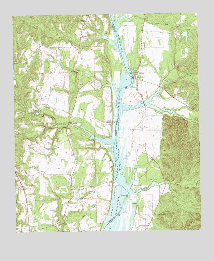
Twin Springs, AL USGS Topographic Map
Click on map above to begin viewing in our Map Viewer.

This topographic map contains these locations and features:
Feature Name Type Latitude Longitude GNIS ID View Map
Bradley LakeReservoirN32.1121°W85.0085°337486View Map
Bradley Lake DamDamN32.1135°W85.0083°337485View Map
Cedar (historical)Populated PlaceN32.0540°W85.1047°134764View Map
Chatts Store (historical)LocaleN32.1038°W85.0794°166032View Map
Cliatt BranchStreamN32.1052°W85.0552°116257View Map
Cliatts Post Office (historical)Post OfficeN32.1038°W85.0794°169247View Map
CoffintonPopulated PlaceN32.0099°W85.0224°331426View Map
Colonel Z Williams Landing (historical)LocaleN32.0646°W85.0560°133227View Map
County Line ChurchChurchN32.0632°W85.0885°133230View Map
First Borne ChurchChurchN32.1140°W85.1141°118302View Map
FlorencePopulated PlaceN32.0913°W85.0410°355851View Map
Florence CemeteryCemeteryN32.0910°W85.0424°347293View Map
Florence Landing Recreation AreaParkN32.0888°W85.0419°355852View Map
Florence Marina State ParkParkN32.0910°W85.0433°347296View Map
Florence School (historical)SchoolN32.0715°W85.0388°347297View Map
Grass CreekStreamN32.0863°W85.0177°314781View Map
Ichabuckler CreekStreamN32.0249°W85.0033°315873View Map
Jernigan ChurchChurchN32.1213°W85.0769°120864View Map
Little Barbour CreekStreamN32.0518°W85.0580°152081View Map
Lower Bradleys LandingLocaleN32.0585°W85.0558°347318View Map
Mathias BranchStreamN32.0285°W85.0222°347323View Map
McClendon CemeteryCemeteryN32.1124°W85.0791°122474View Map
Mount McKeithan ChurchChurchN32.0418°W85.0344°318688View Map
Mount Moriah ChurchChurchN32.0924°W85.0824°123253View Map
Old Zion Hill CemeteryCemeteryN32.0235°W85.0708°124271View Map
Rankin LandingLocaleN32.0015°W85.0477°347341View Map
River Bethel ChurchChurchN32.0093°W85.0283°321626View Map
Roaches Mills (historical)LocaleN32.0682°W85.1116°134817View Map
Roanoke (historical)Populated PlaceN32.0315°W85.0527°347345View Map
Rocky Mount ChurchChurchN32.0113°W85.1002°134819View Map
Rood CreekStreamN32.0285°W85.0219°321888View Map
Rood Creek Landing Recreation AreaParkN32.0257°W85.0424°321889View Map
Sheppard Plantation Battle MonumentParkN32.1046°W85.0383°347353View Map
Smiths PondReservoirN32.0185°W85.0820°127052View Map
Talipahoga Rum CreekStreamN32.1229°W85.0427°356578View Map
Thompson LandingLocaleN32.0418°W85.0555°347367View Map
Thompson Store (historical)LocaleN32.0499°W85.0366°347368View Map
Trinity CemeteryCemeteryN32.0907°W85.0405°324297View Map
Turner CreekStreamN32.0668°W85.0160°356599View Map
Twin SpringsLocaleN32.0624°W85.0885°153749View Map
Union Grove CemeteryCemeteryN32.1101°W85.0958°138325View Map
Williams CemeteryCemeteryN32.0715°W85.1005°129002View Map
Williams Mills (historical)LocaleN32.0479°W85.0610°134838View Map
Wool Ridge Landing (historical)LocaleN32.0432°W85.0610°134842View Map
Zion Hill ChurchChurchN32.0215°W85.0708°134844View Map
Zion Hill ChurchChurchN32.0213°W85.0869°129350View Map

Note: Coordinates in the location and feature list above are referenced to NAD83 datum.


Copyright (C) 2008-2025 Ryan Niemi / Sunset Dynamics ... All Rights Reserved