TopoQuest Logo
Do you find TopoQuest useful?
Help keep TopoQuest running and adding new maps/features by donating!
Bitcoin:  19c7KJd3qBynnjoSw5npx9KScwjBe4ifkT
Litecoin:  LXs6TkuXGGXo1vDsWCkWVdjQX94eUKd6ui
Home View Maps Find Maps Find Places Resources & Links


Longtown, South Carolina Topographic Map

USGS Map Title: Longtown, SC
USGS Map MRC: 34080C7
DRG (GeoTIFF) Download: o34080c7.tif


Neighboring USGS Topographic Map Quads:


  Flint Hill, SC  
34080D8
 

  Liberty Hill, SC  
34080D7
 

  White Oak Creek, SC  
34080D6
 

  Ridgeway, SC  
34080C8
 

  Longtown, SC  
34080C7
 

  Rabon Crossroads, SC  
34080C6
 

  Blythewood, SC  
34080B8
 

  Elgin, SC  
34080B7
 

  Lugoff, SC  
34080B6


Map MRC Location:

N35°
W81°
N35°
W80°
H8 H7 H6 H5 H4 H3 H2 H1
G8 G7 G6 G5 G4 G3 G2 G1
F8 F7 F6 F5 F4 F3 F2 F1
E8 E7 E6 E5 E4 E3 E2 E1
D8 D7 D6 D5 D4 D3 D2 D1
C8 C7 C6 C5 C4 C3 C2 C1
B8 B7 B6 B5 B4 B3 B2 B1
A8 A7 A6 A5 A4 A3 A2 A1
N34°
W81°
N34°
W80°

Longtown, SC USGS 1:24K Topographic Map Preview:
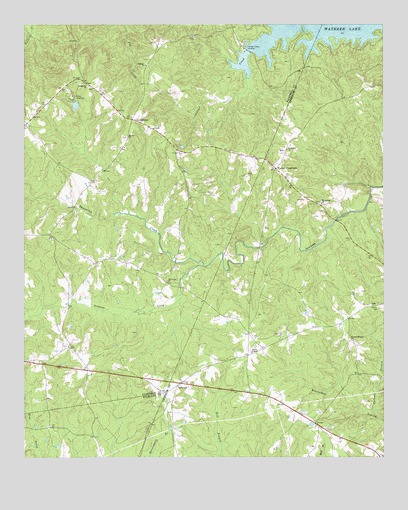
Longtown, SC USGS Topographic Map
Click on map above to begin viewing in our Map Viewer.

This topographic map contains these locations and features:
Feature Name Type Latitude Longitude GNIS ID View Map
Antioch CemeteryCemeteryN34.3718°W80.8170°1220212View Map
Antioch ChurchChurchN34.3635°W80.8320°1220218View Map
Bellfield (historical)Populated PlaceN34.2901°W80.8006°1235011View Map
Camp LongridgeLocaleN34.3546°W80.8579°1221257View Map
Camp Longridge LakeReservoirN34.3518°W80.8569°1239025View Map
Camp Longridge Lake Dam D-0534DamN34.3501°W80.8565°1239024View Map
Centerville School (historical)SchoolN34.2735°W80.8526°1236996View Map
Church of GodChurchN34.2824°W80.8595°1237000View Map
Colonel CreekStreamN34.3738°W80.7842°1247348View Map
Colonel Creek LandingPopulated PlaceN34.3690°W80.7970°1231187View Map
Crims Mill (historical)LocaleN34.3182°W80.7665°1235069View Map
Fairfield County Fire Department SoutheasternBuildingN34.3448°W80.8384°2578408View Map
Hopewell School (historical)SchoolN34.2574°W80.7693°1235107View Map
Horse Pen CreekStreamN34.3115°W80.7909°1237030View Map
Jackson CemeteryCemeteryN34.2938°W80.7517°1223498View Map
James ChapelChurchN34.2804°W80.7956°1246150View Map
LongtownPopulated PlaceN34.3476°W80.8373°1246466View Map
Longtown CemeteryCemeteryN34.3571°W80.8520°1248802View Map
Longtown ChurchChurchN34.3574°W80.8520°1246467View Map
Mount Joshua ChurchChurchN34.3235°W80.7715°1249591View Map
Mount Joshua School (historical)SchoolN34.3235°W80.7723°1235153View Map
Mount Olive ChurchChurchN34.3426°W80.8384°1224750View Map
Rock Hill CemeteryCemeteryN34.3388°W80.7834°1253363View Map
Rock Hill ChurchChurchN34.3388°W80.7834°1250423View Map
Smyrna Camp Ground (historical)LocaleN34.2715°W80.8206°1235211View Map
Smyrna ChurchChurchN34.2710°W80.8215°1226715View Map
Sutton Branch Baptist ChurchChurchN34.2840°W80.7606°1251083View Map
Suttons BranchStreamN34.2629°W80.7531°1226983View Map
Thorntree CreekStreamN34.3054°W80.8123°1251160View Map
Thorntree School (historical)SchoolN34.3063°W80.8493°1237097View Map
Turner School (historical)SchoolN34.2757°W80.8415°1237098View Map
Warren CrossroadsPopulated PlaceN34.3335°W80.7870°1251326View Map
White Oak ChurchChurchN34.3010°W80.8251°1227544View Map
Woods School (historical)SchoolN34.2829°W80.7598°1235254View Map

Note: Coordinates in the location and feature list above are referenced to NAD83 datum.


Copyright (C) 2008-2024 Ryan Niemi / Sunset Dynamics ... All Rights Reserved