TopoQuest Logo
Do you find TopoQuest useful?
Help keep TopoQuest running and adding new maps/features by donating!
Bitcoin:  19c7KJd3qBynnjoSw5npx9KScwjBe4ifkT
Litecoin:  LXs6TkuXGGXo1vDsWCkWVdjQX94eUKd6ui
Home View Maps Find Maps Find Places Resources & Links


Underwood Lake, New Mexico Topographic Map

USGS Map Title: Underwood Lake, NM
USGS Map MRC: 33108H8
DRG (GeoTIFF) Download: o33108h8.tif


Neighboring USGS Topographic Map Quads:


  Loco Knoll, AZ  
34109A1
 

  Jones Canyon, NM  
34108A8
 

  Black Peak, NM  
34108A7
 

  Escudilla Mountain, AZ  
33109H1
 

  Underwood Lake, NM  
33108H8
 

  Centerfire Bog, NM  
33108H7
 

  Luna Lake, AZ  
33109G1
 

  Luna, NM  
33108G8
 

  Dillon Mountain, NM  
33108G7


Map MRC Location:

N34°
W109°
N34°
W108°
H8 H7 H6 H5 H4 H3 H2 H1
G8 G7 G6 G5 G4 G3 G2 G1
F8 F7 F6 F5 F4 F3 F2 F1
E8 E7 E6 E5 E4 E3 E2 E1
D8 D7 D6 D5 D4 D3 D2 D1
C8 C7 C6 C5 C4 C3 C2 C1
B8 B7 B6 B5 B4 B3 B2 B1
A8 A7 A6 A5 A4 A3 A2 A1
N33°
W109°
N33°
W108°

Underwood Lake, NM USGS 1:24K Topographic Map Preview:
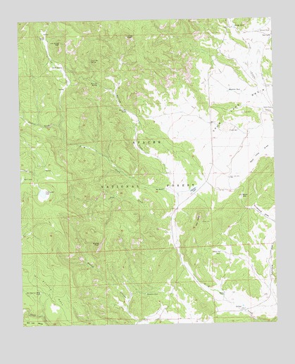
Underwood Lake, NM USGS Topographic Map
Click on map above to begin viewing in our Map Viewer.

This topographic map contains these locations and features:
Feature Name Type Latitude Longitude GNIS ID View Map
Arroyo TankReservoirN33.9969°W108.8943°903427View Map
Bar C LakeLakeN33.9351°W108.9996°923555View Map
Bastion RanchLocaleN33.8876°W108.9011°903603View Map
Big TankReservoirN33.8751°W108.9840°898725View Map
Bill Lee MesaSummitN33.8789°W108.9992°903823View Map
Bishop PeakSummitN33.9084°W108.9623°903840View Map
Black GapGapN33.9276°W108.8917°903862View Map
Black Gap TankReservoirN33.9046°W108.9027°903863View Map
Boswell WellWellN33.9964°W108.8948°904024View Map
Frank TankReservoirN33.9062°W108.8920°913251View Map
Funderburg Tank Number TwoReservoirN33.8929°W108.8774°913252View Map
Gribble PlaceLocaleN33.9631°W108.8759°906743View Map
Heddrick TankReservoirN33.9707°W108.8983°906897View Map
Hell Roaring Mesa TankReservoirN33.8886°W108.9917°906908View Map
Hulsey LakeLakeN33.9299°W108.9155°907161View Map
Jenkins CreekStreamN33.9576°W108.9809°907347View Map
Jim Smith PeakSummitN33.9909°W108.9798°907373View Map
Jones PeakSummitN33.9934°W108.9465°907431View Map
Karruth CreekStreamN33.9270°W108.9234°907504View Map
Karruth SpringSpringN33.9740°W108.9618°907505View Map
Karruth TankReservoirN33.9628°W108.9481°907506View Map
Karruth Tank Number TwoReservoirN33.9837°W108.9512°913245View Map
Knowlton TankReservoirN33.8878°W108.9396°907584View Map
Lost SpringSpringN33.9073°W108.9829°913250View Map
Morrison TankReservoirN33.9463°W108.9982°1985080View Map
Red ButteSummitN33.9187°W108.9126°910041View Map
SA TankReservoirN33.9305°W108.9304°910492View Map
SA Tank Number TwoReservoirN33.9376°W108.9505°913253View Map
Sand CreekStreamN33.9181°W108.9256°910728View Map
Smith CreekStreamN33.9576°W108.9809°911152View Map
Smith SpringSpringN33.9810°W108.9789°911157View Map
Smith TankReservoirN33.9931°W108.9876°911158View Map
Spur LakePopulated PlaceN33.9931°W108.8759°911358View Map
Spur Lake CemeteryCemeteryN33.9614°W108.8915°911360View Map
Spur Lake Post Office (historical)Post OfficeN33.9931°W108.8759°938511View Map
Spur Lake WellWellN33.9348°W108.8973°911362View Map
Stroud TankReservoirN33.9948°W108.8818°2038704View Map
Tipton WellWellN33.9539°W108.8970°911726View Map
Todilto ParkAreaN33.9501°W108.9590°898454View Map
Twin Doe SpringSpringN33.9834°W108.9649°911927View Map
Underwood LakeLakeN33.9292°W108.9898°911955View Map

Note: Coordinates in the location and feature list above are referenced to NAD83 datum.


Copyright (C) 2008-2025 Ryan Niemi / Sunset Dynamics ... All Rights Reserved