TopoQuest Logo
Do you find TopoQuest useful?
Help keep TopoQuest running and adding new maps/features by donating!
Bitcoin:  19c7KJd3qBynnjoSw5npx9KScwjBe4ifkT
Litecoin:  LXs6TkuXGGXo1vDsWCkWVdjQX94eUKd6ui
Home View Maps Find Maps Find Places Resources & Links


Black Peak, New Mexico Topographic Map

USGS Map Title: Black Peak, NM
USGS Map MRC: 34108A7
DRG (GeoTIFF) Download: o34108a7.tif


Neighboring USGS Topographic Map Quads:


  Cow Springs, NM  
34108B8
 

  Red Hill, NM  
34108B7
 

  Ponderosa Tank, NM  
34108B6
 

  Jones Canyon, NM  
34108A8
 

  Black Peak, NM  
34108A7
 

  Gallo Mountains West, NM  
34108A6
 

  Underwood Lake, NM  
33108H8
 

  Centerfire Bog, NM  
33108H7
 

  Queens Head, NM  
33108H6


Map MRC Location:

N35°
W109°
N35°
W108°
H8 H7 H6 H5 H4 H3 H2 H1
G8 G7 G6 G5 G4 G3 G2 G1
F8 F7 F6 F5 F4 F3 F2 F1
E8 E7 E6 E5 E4 E3 E2 E1
D8 D7 D6 D5 D4 D3 D2 D1
C8 C7 C6 C5 C4 C3 C2 C1
B8 B7 B6 B5 B4 B3 B2 B1
A8 A7 A6 A5 A4 A3 A2 A1
N34°
W109°
N34°
W108°

Black Peak, NM USGS 1:24K Topographic Map Preview:
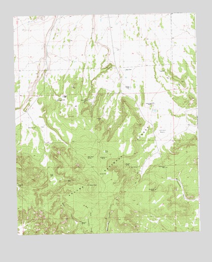
Black Peak, NM USGS Topographic Map
Click on map above to begin viewing in our Map Viewer.

This topographic map contains these locations and features:
Feature Name Type Latitude Longitude GNIS ID View Map
Baca SpringSpringN34.0348°W108.7770°1923334View Map
Black PeakSummitN34.0278°W108.8248°1923262View Map
Black TankReservoirN34.0310°W108.8377°1923336View Map
Boggy TankReservoirN34.0785°W108.8420°1923341View Map
Buck TankReservoirN34.0934°W108.7987°1923327View Map
Dripping SpringSpringN34.0434°W108.8142°1923331View Map
Dry TankReservoirN34.0920°W108.7754°1923326View Map
Gully TankReservoirN34.0762°W108.8651°2038492View Map
Harcastle GapGapN34.0356°W108.7734°1923322View Map
Hardcastle SpringSpringN34.0245°W108.7809°1923323View Map
Hardcastle WellWellN34.0301°W108.7665°936627View Map
Harrys TankReservoirN34.0341°W108.8132°936628View Map
Higbsib Basub SoprubgSpringN34.0717°W108.7773°936629View Map
Johnson BasinBasinN34.0681°W108.7773°907399View Map
Johnson BasinBasinN34.0584°W108.7715°1923324View Map
Johnson Basin SpringSpringN34.0717°W108.7773°936630View Map
Johnson Basin WindmillLocaleN34.0737°W108.7809°1923325View Map
Johnson TankReservoirN34.0837°W108.7959°1923328View Map
Jones SpringSpringN34.0764°W108.8251°1923329View Map
Juniper TankReservoirN34.0689°W108.8403°2038527View Map
Leaky TankReservoirN34.0339°W108.8495°1923337View Map
Malpais SpringSpringN34.0070°W108.8309°1923335View Map
Mangitas FlatFlatN34.0612°W108.8590°1923339View Map
Mangitas Storage TankReservoirN34.0484°W108.8517°2038559View Map
Mullen TankReservoirN34.0698°W108.8142°2038583View Map
No Agua TankReservoirN34.0767°W108.8462°1923340View Map
Renfro CanyonValleyN34.0731°W108.7687°910127View Map
Ridge TankReservoirN34.0059°W108.8278°2038645View Map
Steel CanyonValleyN34.0695°W108.7673°1923435View Map
Trap TankReservoirN34.0470°W108.8142°1923332View Map
Troughs SpringSpringN34.0392°W108.8001°1923333View Map
Water Canyon TankReservoirN34.0164°W108.8442°2038749View Map
White Bluff SpringSpringN34.0434°W108.8259°1923330View Map
Woodside TankReservoirN34.0281°W108.8746°1923338View Map

Note: Coordinates in the location and feature list above are referenced to NAD83 datum.


Copyright (C) 2008-2025 Ryan Niemi / Sunset Dynamics ... All Rights Reserved