TopoQuest Logo
Do you find TopoQuest useful?
Help keep TopoQuest running and adding new maps/features by donating!
Bitcoin:  19c7KJd3qBynnjoSw5npx9KScwjBe4ifkT
Litecoin:  LXs6TkuXGGXo1vDsWCkWVdjQX94eUKd6ui
Home View Maps Find Maps Find Places Resources & Links


Scipio Center, New York Topographic Map

USGS Map Title: Scipio Center, NY
USGS Map MRC: 42076G5
DRG (GeoTIFF) Download: o42076g5.tif


Neighboring USGS Topographic Map Quads:


  Cayuga, NY  
42076H6
 

  Auburn, NY  
42076H5
 

  Skaneateles, NY  
42076H4
 

  Union Springs, NY  
42076G6
 

  Scipio Center, NY  
42076G5
 

  Owasco, NY  
42076G4
 

  Sheldrake, NY  
42076F6
 

  Genoa, NY  
42076F5
 

  Moravia, NY  
42076F4


Map MRC Location:

N43°
W77°
N43°
W76°
H8 H7 H6 H5 H4 H3 H2 H1
G8 G7 G6 G5 G4 G3 G2 G1
F8 F7 F6 F5 F4 F3 F2 F1
E8 E7 E6 E5 E4 E3 E2 E1
D8 D7 D6 D5 D4 D3 D2 D1
C8 C7 C6 C5 C4 C3 C2 C1
B8 B7 B6 B5 B4 B3 B2 B1
A8 A7 A6 A5 A4 A3 A2 A1
N42°
W77°
N42°
W76°

Scipio Center, NY USGS 1:24K Topographic Map Preview:
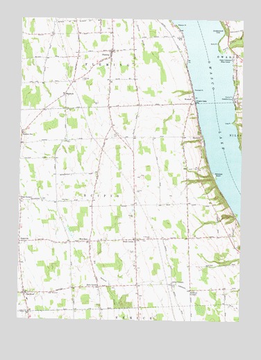
Scipio Center, NY USGS Topographic Map
Click on map above to begin viewing in our Map Viewer.

This topographic map contains these locations and features:
Feature Name Type Latitude Longitude GNIS ID View Map
Arnold - Comstock CemeteryCemeteryN42.8708°W76.5750°2519225View Map
Babcock Family CemeteryCemeteryN42.8020°W76.5404°2519244View Map
Bolts CornersLocaleN42.7640°W76.5794°944412View Map
Bolts Corners CemeteryCemeteryN42.7634°W76.5718°2519242View Map
Botsford CornersLocaleN42.7626°W76.5274°944479View Map
Burch CemeteryCemeteryN42.8156°W76.5314°2519245View Map
Burtis PointCapeN42.8653°W76.5144°945295View Map
Camp ColumbusLocaleN42.8590°W76.5058°945566View Map
Conklin CovePopulated PlaceN42.8423°W76.5049°947290View Map
Cornwall CemeteryCemeteryN42.8035°W76.5587°947482View Map
Covey CornersLocaleN42.7653°W76.5380°947583View Map
Devine CemeteryCemeteryN42.8237°W76.5331°2519246View Map
Dutch Hollow BrookStreamN42.8615°W76.5110°970086View Map
Eddy CemeteryCemeteryN42.7993°W76.5977°949357View Map
ElmwoodPopulated PlaceN42.8267°W76.5233°972447View Map
Emily Howland High SchoolSchoolN42.7583°W76.6197°2120969View Map
EnsenorePopulated PlaceN42.7939°W76.5033°2120967View Map
Ensenore PointCapeN42.7944°W76.5017°2541767View Map
Fays PointCapeN42.8597°W76.5306°2541771View Map
FlemingPopulated PlaceN42.8617°W76.5741°950272View Map
Fleming CemeteryCemeteryN42.8501°W76.5903°950273View Map
Fleming Federated ChurchChurchN42.8590°W76.5750°2597470View Map
Fleming Fire Department Station 2BuildingN42.8620°W76.5736°2701306View Map
Fordyce CemeteryCemeteryN42.7931°W76.5606°2519253View Map
Glenwood BeachBeachN42.8103°W76.5149°951235View Map
Glenwood PointCapeN42.8100°W76.5147°2541770View Map
Gould - Akin CemeteryCemeteryN42.7561°W76.5785°2519241View Map
Killian Airfield (historical)AirportN42.8000°W76.5809°978288View Map
Kings CornersLocaleN42.7990°W76.6241°954661View Map
Koenig PointCapeN42.8440°W76.5052°954800View Map
KRC FarmsLocaleN42.8639°W76.5108°2515531View Map
Lindenwood CoveBayN42.8698°W76.5130°955405View Map
Long PointCapeN42.8326°W76.5049°955894View Map
Manchester Family CemeteryCemeteryN42.7998°W76.6119°2519243View Map
MapletonPopulated PlaceN42.8437°W76.5999°956462View Map
MerrifieldPopulated PlaceN42.7828°W76.5849°972791View Map
Number OneLocaleN42.8273°W76.6230°959061View Map
Owasco LakeReservoirN42.8342°W76.5101°970442View Map
Owasco Lake Mennonite ChurchChurchN42.8472°W76.5738°2597475View Map
Owasco Lake StationPopulated PlaceN42.8406°W76.5263°959670View Map
Peterson PointCapeN42.8726°W76.5374°960248View Map
Plunckett PointCapeN42.8459°W76.5277°960782View Map
Saint Bernard CemeteryCemeteryN42.7843°W76.5498°963376View Map
Saint Bernard's Catholic ChurchChurchN42.7833°W76.5550°2519239View Map
Saint Bernard's Old Catholic CemeteryCemeteryN42.7830°W76.5549°2519238View Map
School Number 1 (historical)SchoolN42.8489°W76.5964°2120970View Map
School Number 1 (historical)SchoolN42.8592°W76.5742°2120971View Map
School Number 10 (historical)SchoolN42.7653°W76.5375°2120981View Map
School Number 14 (historical)SchoolN42.7631°W76.5089°2120982View Map
School Number 2 (historical)SchoolN42.8261°W76.5336°2120972View Map
School Number 3 (historical)SchoolN42.8217°W76.5786°2120973View Map
School Number 3 (historical)SchoolN42.8394°W76.5569°2120974View Map
School Number 4 (historical)SchoolN42.7631°W76.5819°2120975View Map
School Number 4 (historical)SchoolN42.7833°W76.5567°2120976View Map
School Number 6 (historical)SchoolN42.8678°W76.5341°975489View Map
School Number 6 (historical)SchoolN42.8167°W76.6047°2120977View Map
School Number 7 (historical)SchoolN42.7983°W76.5303°2120978View Map
School Number 8 (historical)SchoolN42.7850°W76.5172°2120979View Map
School Number 9 (historical)SchoolN42.8258°W76.6239°2120980View Map
Scipio CenterPopulated PlaceN42.7837°W76.5591°964654View Map
Scipio Center Post OfficePost OfficeN42.7802°W76.5582°2598477View Map
Scipio Fire DepartmentBuildingN42.7896°W76.5587°2701264View Map
Scipio Rural CemeteryCemeteryN42.7784°W76.5590°963086View Map
ScipiovillePopulated PlaceN42.7820°W76.6249°964655View Map
SherwoodPopulated PlaceN42.7609°W76.6213°965095View Map
Sherwood - Phelps CemeteryCemeteryN42.7641°W76.6223°2519240View Map
Southern Cayuga Elementary School Howland BuildingSchoolN42.7583°W76.6194°2597457View Map
Spruce Haven FarmLocaleN42.8603°W76.6081°2515533View Map
Town of FlemingCivilN42.8700°W76.5778°978959View Map
Town of ScipioCivilN42.7948°W76.5614°979476View Map
Woods Mill Pond (historical)ReservoirN42.7597°W76.5703°2120968View Map
WyckoffPopulated PlaceN42.8420°W76.5274°973298View Map

Note: Coordinates in the location and feature list above are referenced to NAD83 datum.


Copyright (C) 2008-2024 Ryan Niemi / Sunset Dynamics ... All Rights Reserved