TopoQuest Logo
Do you find TopoQuest useful?
Help keep TopoQuest running and adding new maps/features by donating!
Bitcoin:  19c7KJd3qBynnjoSw5npx9KScwjBe4ifkT
Litecoin:  LXs6TkuXGGXo1vDsWCkWVdjQX94eUKd6ui
Home View Maps Find Maps Find Places Resources & Links


Uvalda, Georgia Topographic Map

USGS Map Title: Uvalda, GA
USGS Map MRC: 32082A5
DRG (GeoTIFF) Download: o32082a5.tif


Neighboring USGS Topographic Map Quads:


  Glenwood, GA  
32082B6
 

  Mount Vernon, GA  
32082B5
 

  Vidalia, GA  
32082B4
 

  Jordan, GA  
32082A6
 

  Uvalda, GA  
32082A5
 

  Alston, GA  
32082A4
 

  Lumber City, GA  
31082H6
 

  Hazlehurst North, GA  
31082H5
 

  Grays Landing, GA  
31082H4


Map MRC Location:

N33°
W83°
N33°
W82°
H8 H7 H6 H5 H4 H3 H2 H1
G8 G7 G6 G5 G4 G3 G2 G1
F8 F7 F6 F5 F4 F3 F2 F1
E8 E7 E6 E5 E4 E3 E2 E1
D8 D7 D6 D5 D4 D3 D2 D1
C8 C7 C6 C5 C4 C3 C2 C1
B8 B7 B6 B5 B4 B3 B2 B1
A8 A7 A6 A5 A4 A3 A2 A1
N32°
W83°
N32°
W82°

Uvalda, GA USGS 1:24K Topographic Map Preview:
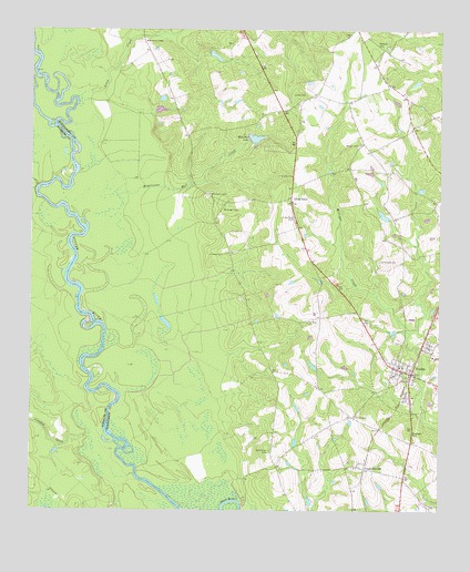
Uvalda, GA USGS Topographic Map
Click on map above to begin viewing in our Map Viewer.

This topographic map contains these locations and features:
Feature Name Type Latitude Longitude GNIS ID View Map
Charlotte ChurchChurchN32.0138°W82.5221°345008View Map
CharlottevillePopulated PlaceN32.0113°W82.5224°331375View Map
City of UvaldaCivilN32.0371°W82.5080°2405632View Map
Conner CemeteryCemeteryN32.0246°W82.5254°312903View Map
Crooked CreekStreamN32.0205°W82.6060°313140View Map
Dead RiverGutN32.0024°W82.5637°313384View Map
Dead River CemeteryCemeteryN32.0155°W82.5512°313390View Map
Gibbs CemeteryCemeteryN32.1082°W82.5454°314577View Map
Hughes PondReservoirN32.1185°W82.5691°341033View Map
Hughes Pond DamDamN32.1185°W82.5699°341032View Map
Johnson CemeteryCemeteryN32.0666°W82.5662°316151View Map
Long PondPopulated PlaceN32.0813°W82.5454°326375View Map
Long Pond CemeteryCemeteryN32.0763°W82.5446°317388View Map
Long Pond ChurchChurchN32.0807°W82.5454°345010View Map
Lotts CreekStreamN32.1085°W82.6071°317424View Map
McAllistor CemeteryCemeteryN32.0827°W82.5704°317833View Map
McAllistor Mill CreekStreamN32.0813°W82.6015°317834View Map
McGregor CemeteryCemeteryN32.0782°W82.5668°317921View Map
New Hope ChurchChurchN32.0491°W82.5401°319388View Map
Oak Grove ChurchChurchN32.1230°W82.5246°345017View Map
Old Salem CemeteryCemeteryN32.0652°W82.5185°320021View Map
Peterson CemeteryCemeteryN32.1210°W82.5196°320414View Map
Rose Dew LakeReservoirN32.0970°W82.5565°336130View Map
Rose Dew Lake DamDamN32.0969°W82.5568°336129View Map
Saint Johns ChurchChurchN32.0871°W82.5454°322119View Map
Thompson ChapelChurchN32.1218°W82.5901°324112View Map
Thompson LakeReservoirN32.1043°W82.5858°340327View Map
Thompson Lake DamDamN32.1035°W82.5865°340326View Map
UvaldaPopulated PlaceN32.0357°W82.5082°324646View Map
Uvalda CemeteryCemeteryN32.0441°W82.5126°345022View Map
Uvalda DivisionCivilN32.0546°W82.5243°1936610View Map
Uvalda Police DepartmentBuildingN32.0362°W82.5079°2733761View Map
Uvalda Post OfficePost OfficeN32.0369°W82.5087°1705308View Map
Uvalda Volunteer Fire DepartmentBuildingN32.0365°W82.5092°2604823View Map
Walker CemeteryCemeteryN32.0952°W82.5249°324767View Map

Note: Coordinates in the location and feature list above are referenced to NAD83 datum.


Copyright (C) 2008-2025 Ryan Niemi / Sunset Dynamics ... All Rights Reserved