TopoQuest Logo
Do you find TopoQuest useful?
Help keep TopoQuest running and adding new maps/features by donating!
Bitcoin:  19c7KJd3qBynnjoSw5npx9KScwjBe4ifkT
Litecoin:  LXs6TkuXGGXo1vDsWCkWVdjQX94eUKd6ui
Home View Maps Find Maps Find Places Resources & Links


Vidalia, Georgia Topographic Map

USGS Map Title: Vidalia, GA
USGS Map MRC: 32082B4
DRG (GeoTIFF) Download: o32082b4.tif


Neighboring USGS Topographic Map Quads:


  Soperton South, GA  
32082C5
 

  Oak Park SW, GA  
32082C4
 

  Oak Park, GA  
32082C3
 

  Mount Vernon, GA  
32082B5
 

  Vidalia, GA  
32082B4
 

  Lyons, GA  
32082B3
 

  Uvalda, GA  
32082A5
 

  Alston, GA  
32082A4
 

  Johnson Corner, GA  
32082A3


Map MRC Location:

N33°
W83°
N33°
W82°
H8 H7 H6 H5 H4 H3 H2 H1
G8 G7 G6 G5 G4 G3 G2 G1
F8 F7 F6 F5 F4 F3 F2 F1
E8 E7 E6 E5 E4 E3 E2 E1
D8 D7 D6 D5 D4 D3 D2 D1
C8 C7 C6 C5 C4 C3 C2 C1
B8 B7 B6 B5 B4 B3 B2 B1
A8 A7 A6 A5 A4 A3 A2 A1
N32°
W83°
N32°
W82°

Vidalia, GA USGS 1:24K Topographic Map Preview:
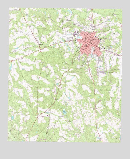
Vidalia, GA USGS Topographic Map
Click on map above to begin viewing in our Map Viewer.

This topographic map contains these locations and features:
Feature Name Type Latitude Longitude GNIS ID View Map
Achenbach LakeReservoirN32.2119°W82.4333°340353View Map
Achenbach Lake DamDamN32.2102°W82.4332°340352View Map
Allen ChapelChurchN32.1896°W82.4512°310451View Map
Bell CemeteryCemeteryN32.1613°W82.4746°311044View Map
Brice Square Shopping CenterLocaleN32.2077°W82.3823°345160View Map
CenterPopulated PlaceN32.1280°W82.3968°312508View Map
Center CemeteryCemeteryN32.1268°W82.3973°345164View Map
Center ChurchChurchN32.1271°W82.3971°345165View Map
CharlesPopulated PlaceN32.2219°W82.4287°331373View Map
City of VidaliaCivilN32.2134°W82.4035°2405649View Map
Dejarnett Pond DamDamN32.1452°W82.4949°341670View Map
Dejarnetts PondReservoirN32.1472°W82.4946°341671View Map
Dickerson High SchoolSchoolN32.2216°W82.4065°355491View Map
Dickerson SchoolSchoolN32.2216°W82.3987°355492View Map
East Park CemeteryCemeteryN32.2168°W82.3985°313782View Map
Eureka ChurchChurchN32.2219°W82.4774°313990View Map
Ferguson CemeteryCemeteryN32.2482°W82.4949°314105View Map
First African Baptist ChurchChurchN32.2219°W82.4096°345177View Map
First Baptist ChurchChurchN32.2171°W82.4132°345178View Map
First National Square Shopping CenterLocaleN32.2174°W82.4124°345181View Map
Gross PondReservoirN32.1531°W82.4374°314934View Map
Gross Pond DamDamN32.1530°W82.4376°341627View Map
HiggstonPopulated PlaceN32.2166°W82.4671°331970View Map
Higgston Baptist ChurchChurchN32.2210°W82.4704°345009View Map
Higgston Volunteer Fire DepartmentBuildingN32.2170°W82.4671°2604031View Map
Hill ChapelChurchN32.2227°W82.4649°315412View Map
Hughes BridgeBridgeN32.1799°W82.3957°345186View Map
Johnson CemeteryCemeteryN32.2235°W82.4593°316152View Map
Kennedy CemeteryCemeteryN32.2205°W82.4587°316379View Map
Mathias CemeteryCemeteryN32.1507°W82.4818°317788View Map
Maxwell Plaza Shopping CenterLocaleN32.2124°W82.3990°345197View Map
McArthur DamDamN32.1919°W82.4982°341668View Map
McArthur LakeReservoirN32.1939°W82.4976°341669View Map
McCrimon CemeteryCemeteryN32.2077°W82.4982°317881View Map
McGowan PondReservoirN32.2308°W82.3980°345198View Map
Meadows Regional Medical CenterHospitalN32.2086°W82.3753°345172View Map
Meadows SchoolSchoolN32.2060°W82.4035°317983View Map
New Hope ChurchChurchN32.1444°W82.4332°319389View Map
North Thompson ChurchChurchN32.2394°W82.4368°319677View Map
Paul Anderson Youth HomeBuildingN32.2346°W82.4057°345206View Map
PetrossPopulated PlaceN32.1480°W82.4668°332648View Map
Pine Crest CemeteryCemeteryN32.2049°W82.4110°320550View Map
Poplar Springs ChurchChurchN32.1832°W82.4374°321039View Map
Saint Paul African Methodist Episcopal ChurchChurchN32.2213°W82.4079°345210View Map
Sharp BridgeBridgeN32.1907°W82.4365°345211View Map
Tabernacle Baptist ChurchChurchN32.2260°W82.4132°345215View Map
Thompson PondLakeN32.2468°W82.4331°324127View Map
Town of HiggstonCivilN32.2164°W82.4670°2405828View Map
Twin LakesReservoirN32.2227°W82.4226°345223View Map
VidaliaPopulated PlaceN32.2177°W82.4135°324704View Map
Vidalia Area Vocational-Technical SchoolSchoolN32.2269°W82.4285°345224View Map
Vidalia ChurchChurchN32.1913°W82.4349°345225View Map
Vidalia City HallBuildingN32.2169°W82.4124°345226View Map
Vidalia Country ClubLocaleN32.2271°W82.3851°344375View Map
Vidalia Development Authority Industrial ParkLocaleN32.1891°W82.3818°345227View Map
Vidalia Fire Department Station 1 HeadquartersBuildingN32.1973°W82.4024°2603822View Map
Vidalia Fire Department Station 2BuildingN32.2208°W82.4117°2604816View Map
Vidalia High SchoolSchoolN32.2269°W82.4276°345228View Map
Vidalia Methodist ChurchChurchN32.2169°W82.4143°345229View Map
Vidalia Police DepartmentBuildingN32.2174°W82.4101°2733668View Map
Vidalia Post OfficePost OfficeN32.2152°W82.4137°352292View Map
Vidalia Presbyterian ChurchChurchN32.2149°W82.4143°345230View Map
Vidalia SchoolSchoolN32.2191°W82.4176°324705View Map
Vidalia-Toombs County LibraryBuildingN32.2113°W82.4151°345231View Map
Virgle BranchStreamN32.1760°W82.3985°345232View Map
WGPH-FM (Vidalia)TowerN32.2341°W82.4810°352812View Map
Williamson ChapelChurchN32.1488°W82.4435°325381View Map
Wilson CemeteryCemeteryN32.2310°W82.4598°325423View Map
WTCQ-FM (Vidalia)TowerN32.2202°W82.4368°352813View Map
WVOP-AM (Vidalia)TowerN32.2202°W82.4368°352584View Map

Note: Coordinates in the location and feature list above are referenced to NAD83 datum.


Copyright (C) 2008-2024 Ryan Niemi / Sunset Dynamics ... All Rights Reserved