TopoQuest Logo
Do you find TopoQuest useful?
Help keep TopoQuest running and adding new maps/features by donating!
Bitcoin:  19c7KJd3qBynnjoSw5npx9KScwjBe4ifkT
Litecoin:  LXs6TkuXGGXo1vDsWCkWVdjQX94eUKd6ui
Home View Maps Find Maps Find Places Resources & Links


Vales Mills, Ohio Topographic Map

USGS Map Title: Vales Mills, OH
USGS Map MRC: 39082B3
DRG (GeoTIFF) Download: o39082b3.tif


Neighboring USGS Topographic Map Quads:


  Zaleski, OH  
39082C4
 

  Mineral, OH  
39082C3
 

  The Plains, OH  
39082C2
 

  McArthur, OH  
39082B4
 

  Vales Mills, OH  
39082B3
 

  Albany, OH  
39082B2
 

  Mulga, OH  
39082A4
 

  Wilkesville, OH  
39082A3
 

  Rutland, OH  
39082A2


Map MRC Location:

N40°
W83°
N40°
W82°
H8 H7 H6 H5 H4 H3 H2 H1
G8 G7 G6 G5 G4 G3 G2 G1
F8 F7 F6 F5 F4 F3 F2 F1
E8 E7 E6 E5 E4 E3 E2 E1
D8 D7 D6 D5 D4 D3 D2 D1
C8 C7 C6 C5 C4 C3 C2 C1
B8 B7 B6 B5 B4 B3 B2 B1
A8 A7 A6 A5 A4 A3 A2 A1
N39°
W83°
N39°
W82°

Vales Mills, OH USGS 1:24K Topographic Map Preview:
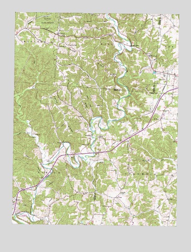
Vales Mills, OH USGS Topographic Map
Click on map above to begin viewing in our Map Viewer.

This topographic map contains these locations and features:
Feature Name Type Latitude Longitude GNIS ID View Map
Alman RunStreamN39.1790°W82.3618°1037381View Map
ArbaughPopulated PlaceN39.1734°W82.3377°1062632View Map
Arbaugh CemeteryCemeteryN39.1784°W82.3582°1037462View Map
Bolin CemeteryCemeteryN39.2259°W82.2732°1038181View Map
Bolins MillsPopulated PlaceN39.2309°W82.2849°1070685View Map
Boring ChurchChurchN39.1890°W82.3221°1038203View Map
Bowens CemeteryCemeteryN39.1774°W82.3097°1038220View Map
Brewer HollowValleyN39.2409°W82.3660°1038289View Map
Brush ForkStreamN39.1631°W82.3193°1066607View Map
Buzzard School (historical)SchoolN39.1906°W82.2896°1071038View Map
Castor CemeteryCemeteryN39.1390°W82.2940°1038870View Map
Chestnut RidgeRidgeN39.1634°W82.2860°1039048View Map
Chestnut Ridge School (historical)SchoolN39.1595°W82.2860°1049494View Map
Columbia ChapelChurchN39.1445°W82.2921°1070718View Map
Cottrill School (historical)SchoolN39.1951°W82.3302°1051909View Map
Cumming CemeteryCemeteryN39.1667°W82.3097°1039534View Map
Dixon HillSummitN39.1951°W82.3090°1039722View Map
Eakin Mill BridgeBridgeN39.1715°W82.3365°1051913View Map
Elk ForkStreamN39.1606°W82.3518°1075799View Map
Flat RunStreamN39.2142°W82.2899°1066711View Map
Flat RunStreamN39.1998°W82.3702°1040511View Map
Flat Run School (historical)SchoolN39.2095°W82.3568°1051915View Map
Gregory CemeteryCemeteryN39.1576°W82.2960°1041179View Map
Gregory CemeteryCemeteryN39.1720°W82.3187°1041180View Map
Grim ChapelChurchN39.1409°W82.2568°1041187View Map
Harkins ChapelChurchN39.2309°W82.3318°1041320View Map
Harkins Chapel CemeteryCemeteryN39.2312°W82.3335°1961640View Map
Hooper ParkParkN39.2406°W82.3515°1062817View Map
Long RunStreamN39.1870°W82.3015°1042751View Map
Mace CemeteryCemeteryN39.1655°W82.3294°1042862View Map
Merritt RunStreamN39.2462°W82.3013°1066834View Map
Mound School (historical)SchoolN39.1540°W82.3332°1051921View Map
Mount BlancoPopulated PlaceN39.1884°W82.2629°1070850View Map
Mount Blanco Post Office (historical)Post OfficeN39.1890°W82.2624°1083306View Map
North Fork Brush ForkStreamN39.1615°W82.3160°1043937View Map
Perry RidgeRidgeN39.2012°W82.3235°1044394View Map
Pierce HollowValleyN39.1542°W82.3521°1044428View Map
Pincher (historical)Populated PlaceN39.1954°W82.3315°1062148View Map
Point RockPopulated PlaceN39.1415°W82.2965°1062948View Map
Point Rock ChurchChurchN39.1359°W82.3015°1070905View Map
Pointrock Post Office (historical)Post OfficeN39.1417°W82.2971°2036708View Map
Putnam ChapelChurchN39.2373°W82.3421°1961656View Map
Putnam Chapel CemeteryCemeteryN39.2373°W82.3424°1961657View Map
Radcliff CemeteryCemeteryN39.1353°W82.3743°1961658View Map
Radcliff United Brethren ChurchChurchN39.1367°W82.3743°1961659View Map
Russell RunStreamN39.2281°W82.2949°1045295View Map
Seldom Seen School (historical)SchoolN39.2198°W82.2832°1051928View Map
Speed RunStreamN39.1876°W82.3132°1046517View Map
Temple CemeteryCemeteryN39.1917°W82.2607°1069827View Map
Temple United Methodist ChurchChurchN39.1929°W82.2604°1070966View Map
Township of ColumbiaCivilN39.1584°W82.2537°1086610View Map
Township of VintonCivilN39.1638°W82.3664°1087109View Map
Union RidgeRidgeN39.2142°W82.3377°1047334View Map
Union Ridge CemeteryCemeteryN39.2134°W82.2985°1961663View Map
Union Ridge ChurchChurchN39.2137°W82.2982°1047335View Map
Union Ridge ChurchChurchN39.2298°W82.3404°1047336View Map
Vales MillsPopulated PlaceN39.1779°W82.3146°1065420View Map
Weaver ChapelChurchN39.2251°W82.2713°1047644View Map
Weaver Chapel CemeteryCemeteryN39.2253°W82.2715°1961665View Map
Whiteoak School (historical)SchoolN39.1320°W82.3346°1051934View Map
Wilton Elementary SchoolSchoolN39.1623°W82.3485°1082079View Map
Zeal (historical)Populated PlaceN39.1965°W82.2960°1049493View Map
Zeal Post Office (historical)Post OfficeN39.1959°W82.2957°2036346View Map
Zinns RunStreamN39.1265°W82.3579°1058157View Map

Note: Coordinates in the location and feature list above are referenced to NAD83 datum.


Copyright (C) 2008-2024 Ryan Niemi / Sunset Dynamics ... All Rights Reserved