TopoQuest Logo
Do you find TopoQuest useful?
Help keep TopoQuest running and adding new maps/features by donating!
Bitcoin:  19c7KJd3qBynnjoSw5npx9KScwjBe4ifkT
Litecoin:  LXs6TkuXGGXo1vDsWCkWVdjQX94eUKd6ui
Home View Maps Find Maps Find Places Resources & Links


Zaleski, Ohio Topographic Map

USGS Map Title: Zaleski, OH
USGS Map MRC: 39082C4
DRG (GeoTIFF) Download: o39082c4.tif


Neighboring USGS Topographic Map Quads:


  South Bloomingville, OH  
39082D5
 

  New Plymouth, OH  
39082D4
 

  Union Furnace, OH  
39082D3
 

  Allensville, OH  
39082C5
 

  Zaleski, OH  
39082C4
 

  Mineral, OH  
39082C3
 

  Hamden, OH  
39082B5
 

  McArthur, OH  
39082B4
 

  Vales Mills, OH  
39082B3


Map MRC Location:

N40°
W83°
N40°
W82°
H8 H7 H6 H5 H4 H3 H2 H1
G8 G7 G6 G5 G4 G3 G2 G1
F8 F7 F6 F5 F4 F3 F2 F1
E8 E7 E6 E5 E4 E3 E2 E1
D8 D7 D6 D5 D4 D3 D2 D1
C8 C7 C6 C5 C4 C3 C2 C1
B8 B7 B6 B5 B4 B3 B2 B1
A8 A7 A6 A5 A4 A3 A2 A1
N39°
W83°
N39°
W82°

Zaleski, OH USGS 1:24K Topographic Map Preview:
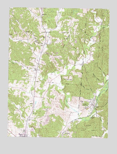
Zaleski, OH USGS Topographic Map
Click on map above to begin viewing in our Map Viewer.

This topographic map contains these locations and features:
Feature Name Type Latitude Longitude GNIS ID View Map
Bethel CemeteryCemeteryN39.3423°W82.4668°1961632View Map
Bethel ChurchChurchN39.3426°W82.4674°1075361View Map
Bethel RidgeRidgeN39.3478°W82.4704°1075363View Map
Bolster HollowValleyN39.3101°W82.3793°1075423View Map
Brushy CreekStreamN39.3087°W82.4354°1075457View Map
Brushy ForkStreamN39.3512°W82.4507°1075458View Map
Church of the NazareneChurchN39.2542°W82.4785°1807475View Map
Coalmont HollowValleyN39.3051°W82.3815°1075601View Map
Cox BridgeBridgeN39.3659°W82.4607°1051911View Map
CreolaPopulated PlaceN39.3153°W82.4663°1075651View Map
Creola CemeteryCemeteryN39.3184°W82.4702°1075652View Map
Dunkle CreekStreamN39.3134°W82.4638°1075754View Map
Elk CemeteryCemeteryN39.2556°W82.4793°1075796View Map
Elk ForkPopulated PlaceN39.2826°W82.4682°1075797View Map
Elk Fork CemeteryCemeteryN39.2665°W82.4740°1075800View Map
Fee CemeteryCemeteryN39.3301°W82.3981°1075839View Map
McArthur ChapelChurchN39.3467°W82.4549°1076354View Map
Mine HollowValleyN39.2940°W82.3913°1076405View Map
Mitchell HollowValleyN39.3228°W82.4154°1077335View Map
Mount Zion CemeteryCemeteryN39.3232°W82.4924°1076463View Map
Oak Grove CemeteryCemeteryN39.2790°W82.4015°1076537View Map
Pleasant Valley ChurchChurchN39.3687°W82.4593°1076661View Map
Prose CemeteryCemeteryN39.3618°W82.4569°1077334View Map
Pumpkin RidgeRidgeN39.3337°W82.4388°1076694View Map
Red DiamondPopulated PlaceN39.2540°W82.4290°1076720View Map
Rocky BranchStreamN39.3465°W82.3993°1076755View Map
Saint Sylvester CemeteryCemeteryN39.2838°W82.4060°1076805View Map
SiverlyPopulated PlaceN39.3490°W82.4999°1076898View Map
Siverly CreekStreamN39.3262°W82.4635°1076899View Map
Swan SchoolSchoolN39.3384°W82.4571°1077010View Map
The PinnacleSummitN39.2551°W82.4010°1062149View Map
Township of ElkCivilN39.2591°W82.4708°1087102View Map
Township of MadisonCivilN39.2541°W82.3767°1087106View Map
Township of SwanCivilN39.3481°W82.4624°1087108View Map
Twomile RunStreamN39.3562°W82.3846°1077092View Map
Ural (historical)Populated PlaceN39.2592°W82.3799°1062150View Map
Village of ZaleskiCivilN39.2811°W82.3950°2399755View Map
Vinton CountyCivilN39.2510°W82.4854°1074093View Map
Vinton County AirportAirportN39.3271°W82.4386°1082815View Map
Vinton County Childrens HomeBuildingN39.2731°W82.4696°1077331View Map
Vinton County Emergency Medical ServicesBuildingN39.2610°W82.4777°2550982View Map
Webb HollowValleyN39.2965°W82.3979°1077155View Map
Wesley Chapel CemeteryCemeteryN39.3456°W82.4269°1077159View Map
Wheelabout CreekStreamN39.2731°W82.3896°1077170View Map
ZaleskiPopulated PlaceN39.2823°W82.3949°1077248View Map
Zaleski Elementary SchoolSchoolN39.2867°W82.3927°1051935View Map
Zaleski State ForestForestN39.2595°W82.3990°1077249View Map
Zaleski State Forest Landing Strip (historical)AirportN39.2728°W82.3938°1077330View Map
Zaleski Volunteer Fire DepartmentBuildingN39.2860°W82.3922°2549561View Map

Note: Coordinates in the location and feature list above are referenced to NAD83 datum.


Copyright (C) 2008-2025 Ryan Niemi / Sunset Dynamics ... All Rights Reserved