TopoQuest Logo
Do you find TopoQuest useful?
Help keep TopoQuest running and adding new maps/features by donating!
Bitcoin:  19c7KJd3qBynnjoSw5npx9KScwjBe4ifkT
Litecoin:  LXs6TkuXGGXo1vDsWCkWVdjQX94eUKd6ui
Home View Maps Find Maps Find Places Resources & Links


Van Buren, Indiana Topographic Map

USGS Map Title: Van Buren, IN
USGS Map MRC: 40085E5
DRG (GeoTIFF) Download: o40085e5.tif


Neighboring USGS Topographic Map Quads:


  La Fontaine, IN  
40085F6
 

  Mount Etna, IN  
40085F5
 

  Warren, IN  
40085F4
 

  Marion, IN  
40085E6
 

  Van Buren, IN  
40085E5
 

  Roll, IN  
40085E4
 

  Fairmount, IN  
40085D6
 

  Gas City, IN  
40085D5
 

  Hartford City West, IN  
40085D4


Map MRC Location:

N41°
W86°
N41°
W85°
H8 H7 H6 H5 H4 H3 H2 H1
G8 G7 G6 G5 G4 G3 G2 G1
F8 F7 F6 F5 F4 F3 F2 F1
E8 E7 E6 E5 E4 E3 E2 E1
D8 D7 D6 D5 D4 D3 D2 D1
C8 C7 C6 C5 C4 C3 C2 C1
B8 B7 B6 B5 B4 B3 B2 B1
A8 A7 A6 A5 A4 A3 A2 A1
N40°
W86°
N40°
W85°

Van Buren, IN USGS 1:24K Topographic Map Preview:
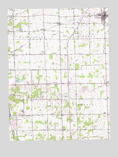
Van Buren, IN USGS Topographic Map
Click on map above to begin viewing in our Map Viewer.

This topographic map contains these locations and features:
Feature Name Type Latitude Longitude GNIS ID View Map
Antioch ChurchChurchN40.5809°W85.5541°430215View Map
ArcanaPopulated PlaceN40.5387°W85.5033°430235View Map
Atkinson CemeteryCemeteryN40.5003°W85.5019°430325View Map
Baker DitchCanalN40.5989°W85.5303°430428View Map
BrookhavenPopulated PlaceN40.5198°W85.6158°431571View Map
Brookhaven Addition LakeReservoirN40.5224°W85.6189°448734View Map
Brookhaven Addition Lake DamDamN40.5217°W85.6200°448733View Map
Brushy RunStreamN40.5975°W85.5486°431694View Map
Buck Run DitchCanalN40.6128°W85.6080°431737View Map
Burson CemeteryCemeteryN40.5530°W85.5773°431875View Map
Center ChapelChurchN40.5245°W85.5078°432316View Map
Club RunStreamN40.5017°W85.5280°432693View Map
Covenant Presbyterian ChurchChurchN40.5242°W85.5722°452275View Map
DoovillePopulated PlaceN40.5534°W85.5600°433640View Map
Fairview CemeteryCemeteryN40.6167°W85.6197°434326View Map
Fletcher ChurchChurchN40.5837°W85.5797°434592View Map
Friendly CornerPopulated PlaceN40.5534°W85.5036°434842View Map
Goff DitchCanalN40.5742°W85.5428°435151View Map
Grant County Emergency Medical Services - Van Buren Medic 6BuildingN40.6182°W85.5054°2719297View Map
Grant County Emergency Medical Services HeadquartersBuildingN40.5065°W85.6143°2719299View Map
Grant County Emergency Medical Services Washington Medic 11BuildingN40.5814°W85.6180°2719320View Map
Griffin ChurchChurchN40.5245°W85.6108°435498View Map
HanfieldPopulated PlaceN40.6045°W85.5803°435674View Map
Johnson DitchCanalN40.5164°W85.5194°437050View Map
Lake MarionLakeN40.5416°W85.5565°438619View Map
Lake WoodPopulated PlaceN40.5531°W85.5680°437546View Map
LandessPopulated PlaceN40.6109°W85.5611°437602View Map
Landess CemeteryCemeteryN40.6023°W85.5605°437603View Map
Landess Census Designated PlaceCensusN40.6126°W85.5593°2583458View Map
Liberty ChapelChurchN40.5239°W85.5594°437824View Map
Lincoln Country Club LakeReservoirN40.5426°W85.5843°448732View Map
Lincoln Country Club Lake DamDamN40.5450°W85.5853°448731View Map
Locust ChapelChurchN40.5670°W85.5958°438206View Map
Loew Lake Dam SouthLakeN40.5573°W85.6145°448392View Map
Ludlum DitchCanalN40.5906°W85.5764°438398View Map
Lugar Creek ChurchChurchN40.5387°W85.5647°438403View Map
Lugar Creek ChurchChurchN40.5437°W85.6189°438404View Map
Monroe DitchCanalN40.5512°W85.5094°439343View Map
Moriarity DitchCanalN40.5864°W85.5055°439439View Map
Necessity DitchCanalN40.6103°W85.5980°439966View Map
Pulley DitchCanalN40.6078°W85.5358°441635View Map
Roosevelt SchoolSchoolN40.5389°W85.6072°442280View Map
ShadelandPopulated PlaceN40.6050°W85.6100°443238View Map
Taylor LakeReservoirN40.5117°W85.5181°448730View Map
Taylor Lake DamDamN40.5117°W85.5200°448729View Map
Tinkle DitchCanalN40.6067°W85.5508°444773View Map
Tippey DitchCanalN40.5731°W85.5547°444783View Map
Town of Van BurenCivilN40.6157°W85.5039°2397709View Map
Township of CenterCivilN40.5404°W85.6194°453178View Map
Township of MonroeCivilN40.5237°W85.5028°453638View Map
Township of Van BurenCivilN40.6102°W85.5044°453946View Map
Township of WashingtonCivilN40.6112°W85.6160°453996View Map
Union ChapelChurchN40.5100°W85.5583°445089View Map
Unthank DitchCanalN40.5723°W85.5714°445155View Map
Van BurenPopulated PlaceN40.6173°W85.5047°445203View Map
Van Buren CemeteryCemeteryN40.6085°W85.5038°438698View Map
Van Buren Elementary and Middle SchoolSchoolN40.6145°W85.5050°446975View Map
Van Buren Police DepartmentBuildingN40.6184°W85.5053°2758213View Map
Van Buren Volunteer Fire DepartmentBuildingN40.6182°W85.5054°2626175View Map
Walnut CreekStreamN40.5209°W85.6244°445413View Map
Washington Elementary SchoolSchoolN40.6187°W85.6175°445517View Map
Washington Township Volunteer Fire Department MarionBuildingN40.5814°W85.6182°2625717View Map

Note: Coordinates in the location and feature list above are referenced to NAD83 datum.


Copyright (C) 2008-2025 Ryan Niemi / Sunset Dynamics ... All Rights Reserved