TopoQuest Logo
Do you find TopoQuest useful?
Help keep TopoQuest running and adding new maps/features by donating!
Bitcoin:  19c7KJd3qBynnjoSw5npx9KScwjBe4ifkT
Litecoin:  LXs6TkuXGGXo1vDsWCkWVdjQX94eUKd6ui
Home View Maps Find Maps Find Places Resources & Links


Hartford City West, Indiana Topographic Map

USGS Map Title: Hartford City West, IN
USGS Map MRC: 40085D4
DRG (GeoTIFF) Download: o40085d4.tif


Neighboring USGS Topographic Map Quads:


  Van Buren, IN  
40085E5
 

  Roll, IN  
40085E4
 

  Montpelier, IN  
40085E3
 

  Gas City, IN  
40085D5
 

  Hartford City West, IN  
40085D4
 

  Hartford City East, IN  
40085D3
 

  Gaston, IN  
40085C5
 

  Wheeling, IN  
40085C4
 

  Eaton, IN  
40085C3


Map MRC Location:

N41°
W86°
N41°
W85°
H8 H7 H6 H5 H4 H3 H2 H1
G8 G7 G6 G5 G4 G3 G2 G1
F8 F7 F6 F5 F4 F3 F2 F1
E8 E7 E6 E5 E4 E3 E2 E1
D8 D7 D6 D5 D4 D3 D2 D1
C8 C7 C6 C5 C4 C3 C2 C1
B8 B7 B6 B5 B4 B3 B2 B1
A8 A7 A6 A5 A4 A3 A2 A1
N40°
W86°
N40°
W85°

Hartford City West, IN USGS 1:24K Topographic Map Preview:
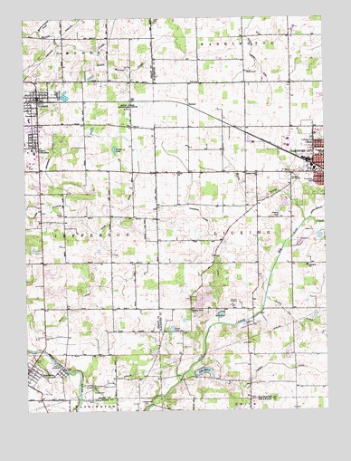
Hartford City West, IN USGS Topographic Map
Click on map above to begin viewing in our Map Viewer.

This topographic map contains these locations and features:
Feature Name Type Latitude Longitude GNIS ID View Map
Bethel Center ChurchChurchN40.4503°W85.4036°430905View Map
Big Lick CreekStreamN40.3750°W85.4514°431044View Map
Cains LakeLakeN40.4012°W85.4393°431945View Map
Dollar LakeLakeN40.4583°W85.4625°433616View Map
Elizabethtown CemeteryCemeteryN40.3769°W85.4510°434072View Map
Fiddler DitchCanalN40.3889°W85.4011°434471View Map
Grant County Emergency Medical Services - Matthews Medic 10BuildingN40.3876°W85.4995°2719296View Map
Hollis DitchCanalN40.4456°W85.4547°436328View Map
Hoovers Airport (historical)AirportN40.4375°W85.3958°449197View Map
Inman Airport (historical)AirportN40.4734°W85.3766°449195View Map
Jefferson DitchCanalN40.4573°W85.4886°436963View Map
Lake MoheeReservoirN40.3874°W85.4264°448596View Map
Lake Mohee DamDamN40.3867°W85.4294°448595View Map
Leffler CemeteryCemeteryN40.4996°W85.4455°437746View Map
Little Joe CreekStreamN40.4109°W85.4008°438082View Map
Little Lick CreekStreamN40.4362°W85.3814°438090View Map
Little Walnut CreekStreamN40.4898°W85.4705°438170View Map
MatthewsPopulated PlaceN40.3887°W85.4994°438731View Map
Matthews Volunteer Fire DepartmentBuildingN40.3876°W85.4994°2625696View Map
Miller Purdue Agricultural CenterBuildingN40.4723°W85.4555°446927View Map
Mills CemeteryCemeteryN40.4795°W85.4271°439242View Map
Monroe Prairie CreekStreamN40.4962°W85.4936°439346View Map
Moore ProngStreamN40.4353°W85.3836°439404View Map
Olive Branch CemeteryCemeteryN40.3785°W85.4725°440637View Map
Parkside Elementary SchoolSchoolN40.4567°W85.3752°440897View Map
Pleasant Grove ChurchChurchN40.4070°W85.4316°441263View Map
Purdue University Memorial FarmLocaleN40.4714°W85.4555°452389View Map
RennerPopulated PlaceN40.4723°W85.4314°441895View Map
Shamrock LakesPopulated PlaceN40.4112°W85.4264°446655View Map
Shields CemeteryCemeteryN40.4823°W85.4019°443376View Map
Shiloh CemeteryCemeteryN40.4374°W85.4844°443387View Map
Smith DitchCanalN40.4103°W85.4769°443676View Map
Taylor UniversitySchoolN40.4584°W85.4953°449737View Map
Town of MatthewsCivilN40.3875°W85.4978°2396741View Map
Town of Shamrock LakesCivilN40.4116°W85.4262°2397652View Map
Townsand Lucas DitchCanalN40.4375°W85.4272°444837View Map
Township of LickingCivilN40.4291°W85.3884°453568View Map
Union ChurchChurchN40.4506°W85.4366°445115View Map
UplandPopulated PlaceN40.4756°W85.4944°445158View Map
Upland Community ChurchChurchN40.4655°W85.5000°2743558View Map
Upland Elementary and Middle SchoolSchoolN40.4695°W85.4953°446974View Map
Upland Police DepartmentBuildingN40.4755°W85.4937°2758344View Map
Upland Volunteer Fire DepartmentBuildingN40.4756°W85.4949°2626169View Map

Note: Coordinates in the location and feature list above are referenced to NAD83 datum.


Copyright (C) 2008-2025 Ryan Niemi / Sunset Dynamics ... All Rights Reserved