TopoQuest Logo
Do you find TopoQuest useful?
Help keep TopoQuest running and adding new maps/features by donating!
Bitcoin:  19c7KJd3qBynnjoSw5npx9KScwjBe4ifkT
Litecoin:  LXs6TkuXGGXo1vDsWCkWVdjQX94eUKd6ui
Home View Maps Find Maps Find Places Resources & Links


Vance, Mississippi Topographic Map

USGS Map Title: Vance, MS
USGS Map MRC: 34090A3
DRG (GeoTIFF) Download: o34090a3.tif


Neighboring USGS Topographic Map Quads:


  Sabino, MS  
34090B4
 

  Lambert, MS  
34090B3
 

  Crowder, MS  
34090B2
 

  Tutwiler, MS  
34090A4
 

  Vance, MS  
34090A3
 

  Fishhook Lake, MS  
34090A2
 

  Rome, MS  
33090H4
 

  Webb, MS  
33090H3
 

  Tippo, MS  
33090H2


Map MRC Location:

N35°
W91°
N35°
W90°
H8 H7 H6 H5 H4 H3 H2 H1
G8 G7 G6 G5 G4 G3 G2 G1
F8 F7 F6 F5 F4 F3 F2 F1
E8 E7 E6 E5 E4 E3 E2 E1
D8 D7 D6 D5 D4 D3 D2 D1
C8 C7 C6 C5 C4 C3 C2 C1
B8 B7 B6 B5 B4 B3 B2 B1
A8 A7 A6 A5 A4 A3 A2 A1
N34°
W91°
N34°
W90°

Vance, MS USGS 1:24K Topographic Map Preview:
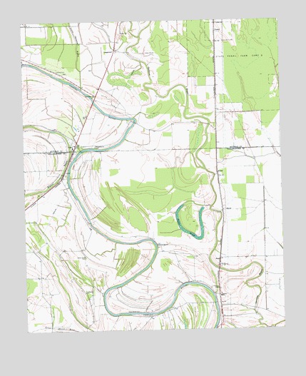
Vance, MS USGS Topographic Map
Click on map above to begin viewing in our Map Viewer.

This topographic map contains these locations and features:
Feature Name Type Latitude Longitude GNIS ID View Map
Beaver Ruin BrakeSwampN34.0862°W90.3043°683722View Map
BrazilPopulated PlaceN34.0265°W90.2806°667534View Map
Carr (historical)LocaleN34.0865°W90.3434°706285View Map
ChancyPopulated PlaceN34.1209°W90.2812°691763View Map
Cinders Band Church (historical)ChurchN34.0840°W90.3712°683731View Map
FewellPopulated PlaceN34.0612°W90.3562°686853View Map
Frison Church (historical)ChurchN34.0062°W90.3254°686859View Map
Goose PondLakeN34.0598°W90.3401°686860View Map
HiramPopulated PlaceN34.0634°W90.2812°671245View Map
Johnson CemeteryCemeteryN34.0171°W90.2820°671925View Map
Johnson SchoolSchoolN34.0137°W90.2806°671949View Map
Little Opossum BayouStreamN34.1090°W90.3168°672653View Map
LongstreetPopulated PlaceN34.1134°W90.3298°692018View Map
Macedonia ChurchChurchN34.0751°W90.3398°673023View Map
Mitchner (historical)Populated PlaceN34.0157°W90.2806°708147View Map
Morning Star ChurchChurchN34.0346°W90.3109°673843View Map
New Hope ChurchChurchN34.0951°W90.3401°674734View Map
New Salem ChurchChurchN34.0154°W90.3459°674844View Map
Pages (historical)LocaleN34.0807°W90.2812°683764View Map
Providence ChurchChurchN34.0057°W90.3315°686867View Map
Shady Grove CemeteryCemeteryN34.0298°W90.3459°677552View Map
Shady Grove School (historical)SchoolN34.0304°W90.3465°686880View Map
Silent Shade CemeteryCemeteryN34.0076°W90.3201°677776View Map
State Penal Farm Camp BLocaleN34.1154°W90.2676°678236View Map
StoverPopulated PlaceN34.0479°W90.2787°678325View Map
Sturdevant Chapel (historical)ChurchN34.0821°W90.3615°683772View Map
Suffer BrakeLakeN34.0405°W90.2983°678382View Map
VancePopulated PlaceN34.0729°W90.3509°679184View Map
Vance Post OfficePost OfficeN34.0745°W90.3504°2768744View Map
Youngs CemeteryCemeteryN34.1204°W90.3273°679971View Map

Note: Coordinates in the location and feature list above are referenced to NAD83 datum.


Copyright (C) 2008-2024 Ryan Niemi / Sunset Dynamics ... All Rights Reserved