TopoQuest Logo
Do you find TopoQuest useful?
Help keep TopoQuest running and adding new maps/features by donating!
Bitcoin:  19c7KJd3qBynnjoSw5npx9KScwjBe4ifkT
Litecoin:  LXs6TkuXGGXo1vDsWCkWVdjQX94eUKd6ui
Home View Maps Find Maps Find Places Resources & Links


Tutwiler, Mississippi Topographic Map

USGS Map Title: Tutwiler, MS
USGS Map MRC: 34090A4
DRG (GeoTIFF) Download: o34090a4.tif


Neighboring USGS Topographic Map Quads:


  Clarksdale, MS  
34090B5
 

  Sabino, MS  
34090B4
 

  Lambert, MS  
34090B3
 

  Mattson, MS  
34090A5
 

  Tutwiler, MS  
34090A4
 

  Vance, MS  
34090A3
 

  Baltzer, MS  
33090H5
 

  Rome, MS  
33090H4
 

  Webb, MS  
33090H3


Map MRC Location:

N35°
W91°
N35°
W90°
H8 H7 H6 H5 H4 H3 H2 H1
G8 G7 G6 G5 G4 G3 G2 G1
F8 F7 F6 F5 F4 F3 F2 F1
E8 E7 E6 E5 E4 E3 E2 E1
D8 D7 D6 D5 D4 D3 D2 D1
C8 C7 C6 C5 C4 C3 C2 C1
B8 B7 B6 B5 B4 B3 B2 B1
A8 A7 A6 A5 A4 A3 A2 A1
N34°
W91°
N34°
W90°

Tutwiler, MS USGS 1:24K Topographic Map Preview:
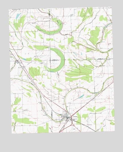
Tutwiler, MS USGS Topographic Map
Click on map above to begin viewing in our Map Viewer.

This topographic map contains these locations and features:
Feature Name Type Latitude Longitude GNIS ID View Map
Arcadia Plantation (historical)LocaleN34.0598°W90.4331°708117View Map
Bower CemeteryCemeteryN34.0898°W90.3876°667472View Map
Carson SloughGutN34.0579°W90.4548°689224View Map
Cedar Grove Church (historical)ChurchN34.1212°W90.3904°683729View Map
Coahoma County Volunteer Fire Department DublinBuildingN34.0736°W90.4919°2666060View Map
County Line ChurchChurchN34.0298°W90.4634°668874View Map
Cunningham ChurchChurchN34.1109°W90.4718°669020View Map
Cypress LakeLakeN34.1021°W90.4593°689244View Map
Cypress Pond (historical)LakeN34.0540°W90.4559°689247View Map
Dry LakeLakeN34.0709°W90.4359°686850View Map
DublinPopulated PlaceN34.0723°W90.4907°669465View Map
Dublin Post OfficePost OfficeN34.0748°W90.4883°2768763View Map
Dublin SchoolSchoolN34.0668°W90.4834°669467View Map
Elm Grove ChurchChurchN34.0537°W90.4732°669751View Map
Fitch (historical)Populated PlaceN34.0309°W90.4565°710432View Map
Flying Y ServiceAirportN34.0060°W90.4252°680418View Map
Galena CemeteryCemeteryN34.0259°W90.4329°670285View Map
Hebrew CemeteryCemeteryN34.0770°W90.4994°671058View Map
Hebrew ChurchChurchN34.0793°W90.4965°671059View Map
Holly Grove ChurchChurchN34.1029°W90.4637°671328View Map
Hopson Bayou Elementary SchoolSchoolN34.0132°W90.4243°711593View Map
Long Dam SloughGutN34.0429°W90.4512°689382View Map
Miller School (historical)SchoolN34.1171°W90.4243°683749View Map
Mount Eagle ChurchChurchN34.0704°W90.4604°673978View Map
Mount Moriah Church (historical)ChurchN34.0768°W90.4148°683751View Map
Muddy BayouStreamN34.0796°W90.3834°674450View Map
Muddy Bayou CemeteryCemeteryN34.0659°W90.3893°674453View Map
New Bethel ChurchChurchN34.1171°W90.4245°674587View Map
New Galilee ChurchChurchN34.0873°W90.3806°674626View Map
Palestine ChurchChurchN34.0384°W90.3979°675401View Map
Philadelphia CemeteryCemeteryN34.0857°W90.4523°675676View Map
Philadelphia School (historical)SchoolN34.0857°W90.4523°689328View Map
Popsons (historical)Populated PlaceN34.0051°W90.4668°689332View Map
Rosemound CemeteryCemeteryN34.0134°W90.4415°676878View Map
Saint Marys ChurchChurchN34.0726°W90.3815°677158View Map
Stillons (historical)Populated PlaceN34.0587°W90.4776°689356View Map
Strong ChapelChurchN34.0073°W90.4070°678368View Map
Tallahatchie County CemeteryCemeteryN34.0801°W90.3993°678547View Map
Tallahatchie County Correctional FacilityBuildingN34.0270°W90.4459°2739812View Map
The Dam (historical)LocaleN34.0582°W90.4418°686892View Map
Thomas ChapelChurchN34.0659°W90.4857°678678View Map
Thompson Chapel (historical)ChurchN34.0518°W90.4765°689369View Map
Town of TutwilerCivilN34.0121°W90.4301°2406769View Map
TutwilerPopulated PlaceN34.0148°W90.4318°678994View Map
Tutwiler Baptist ChurchChurchN34.0187°W90.4331°686894View Map
Tutwiler Elementary School (historical)SchoolN34.0198°W90.4329°708166View Map
Tutwiler Police DepartmentBuildingN34.0163°W90.4317°2754144View Map
Tutwiler Post OfficePost OfficeN34.0161°W90.4304°2768707View Map
Tutwiler Volunteer Fire DepartmentBuildingN34.0162°W90.4307°2665993View Map
Walnut BayouStreamN34.0823°W90.3948°679294View Map
Whitfield ChurchChurchN34.0182°W90.4576°679645View Map
Wrights Chapel Church of God and ChristChurchN34.0134°W90.4395°686900View Map

Note: Coordinates in the location and feature list above are referenced to NAD83 datum.


Copyright (C) 2008-2025 Ryan Niemi / Sunset Dynamics ... All Rights Reserved