TopoQuest Logo
Do you find TopoQuest useful?
Help keep TopoQuest running and adding new maps/features by donating!
Bitcoin:  19c7KJd3qBynnjoSw5npx9KScwjBe4ifkT
Litecoin:  LXs6TkuXGGXo1vDsWCkWVdjQX94eUKd6ui
Home View Maps Find Maps Find Places Resources & Links


Webb, Mississippi Topographic Map

USGS Map Title: Webb, MS
USGS Map MRC: 33090H3
DRG (GeoTIFF) Download: o33090h3.tif


Neighboring USGS Topographic Map Quads:


  Tutwiler, MS  
34090A4
 

  Vance, MS  
34090A3
 

  Fishhook Lake, MS  
34090A2
 

  Rome, MS  
33090H4
 

  Webb, MS  
33090H3
 

  Tippo, MS  
33090H2
 

  Brooks, MS  
33090G4
 

  Glendora, MS  
33090G3
 

  Philipp, MS  
33090G2


Map MRC Location:

N34°
W91°
N34°
W90°
H8 H7 H6 H5 H4 H3 H2 H1
G8 G7 G6 G5 G4 G3 G2 G1
F8 F7 F6 F5 F4 F3 F2 F1
E8 E7 E6 E5 E4 E3 E2 E1
D8 D7 D6 D5 D4 D3 D2 D1
C8 C7 C6 C5 C4 C3 C2 C1
B8 B7 B6 B5 B4 B3 B2 B1
A8 A7 A6 A5 A4 A3 A2 A1
N33°
W91°
N33°
W90°

Webb, MS USGS 1:24K Topographic Map Preview:
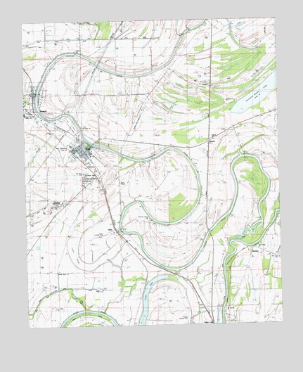
Webb, MS USGS Topographic Map
Click on map above to begin viewing in our Map Viewer.

This topographic map contains these locations and features:
Feature Name Type Latitude Longitude GNIS ID View Map
AlbinPopulated PlaceN33.9134°W90.3298°666174View Map
Arbin LandingLocaleN33.8843°W90.2790°708116View Map
Black BayouGutN33.8801°W90.3518°667195View Map
Brooklyn ChurchChurchN33.9565°W90.3470°686841View Map
Buzzard Bayou LakeLakeN33.9727°W90.2520°686843View Map
Cassidy BayouStreamN33.9098°W90.2729°668139View Map
Cassidy Bayou LandingLocaleN33.9096°W90.2748°708127View Map
Cypress Brake (historical)SwampN33.9407°W90.3645°686849View Map
Friendship Temple ChurchChurchN33.9365°W90.3459°686858View Map
Frierson ChapelChurchN33.9926°W90.3295°670253View Map
Good Hope ChurchChurchN33.9234°W90.3579°670486View Map
Jenkins CemeteryCemeteryN33.9882°W90.3479°671835View Map
Kings ChapelChurchN33.9184°W90.2756°672171View Map
Midway (historical)Populated PlaceN33.9901°W90.2993°708146View Map
MikomaPopulated PlaceN33.9504°W90.2840°673562View Map
Mount Levy ChurchChurchN33.9021°W90.2509°686864View Map
Mount Moriah ChurchChurchN33.8821°W90.2759°674075View Map
Old Bethel ChurchChurchN33.9062°W90.2606°675161View Map
Petty ChapelChurchN33.9590°W90.3587°675667View Map
Pilgrim ChurchChurchN33.9518°W90.2818°675733View Map
Pleasant Grove ChurchChurchN33.9193°W90.3140°676034View Map
Rainbow PlantationLocaleN33.9251°W90.3570°686869View Map
Saint James Church (historical)ChurchN33.9940°W90.2968°686873View Map
Saint Marks ChurchChurchN33.9771°W90.2973°677136View Map
Sandy Bayou ChurchChurchN33.8968°W90.3595°677375View Map
SharkeyPopulated PlaceN33.9051°W90.2648°686881View Map
Sharkeys LandingLocaleN33.9068°W90.2640°708155View Map
Smith ChapelChurchN33.9329°W90.3281°677917View Map
Snow BrakeSwampN33.9001°W90.3456°677963View Map
Snow Brake LakeLakeN33.9004°W90.3487°686882View Map
Sturdivant Church (historical)ChurchN33.8779°W90.3209°686885View Map
SumnerPopulated PlaceN33.9709°W90.3687°678403View Map
Sumner Church of GodChurchN33.9721°W90.3709°686886View Map
Sumner Elementary SchoolSchoolN33.9696°W90.3654°708158View Map
Sumner Fire DepartmentBuildingN33.9706°W90.3711°2665771View Map
Sumner Post OfficePost OfficeN33.9718°W90.3699°2768736View Map
Tallahatchie County Sheriff's OfficeBuildingN33.9701°W90.3710°2754074View Map
Town of SumnerCivilN33.9693°W90.3693°2406688View Map
Town of WebbCivilN33.9477°W90.3463°2406848View Map
TurnerPopulated PlaceN33.9737°W90.2848°686893View Map
WebbPopulated PlaceN33.9473°W90.3443°679411View Map
Webb Baptist ChurchChurchN33.9457°W90.3462°686895View Map
Webb Post OfficePost OfficeN33.9467°W90.3453°2768771View Map
Webb Town Fire DepartmentBuildingN33.9458°W90.3445°2665742View Map
Webb Town Police DepartmentBuildingN33.9458°W90.3445°2754192View Map
West District Elementary SchoolSchoolN33.9490°W90.3481°708169View Map
West District High SchoolSchoolN33.9621°W90.3745°686896View Map
West Tallahatchie High SchoolSchoolN33.9487°W90.3520°686897View Map
Woodlawn CemeteryCemeteryN33.9587°W90.3598°686899View Map

Note: Coordinates in the location and feature list above are referenced to NAD83 datum.


Copyright (C) 2008-2024 Ryan Niemi / Sunset Dynamics ... All Rights Reserved