TopoQuest Logo
Do you find TopoQuest useful?
Help keep TopoQuest running and adding new maps/features by donating!
Bitcoin:  19c7KJd3qBynnjoSw5npx9KScwjBe4ifkT
Litecoin:  LXs6TkuXGGXo1vDsWCkWVdjQX94eUKd6ui
Home View Maps Find Maps Find Places Resources & Links


Vance, South Carolina Topographic Map

USGS Map Title: Vance, SC
USGS Map MRC: 33080D4
DRG (GeoTIFF) Download: o33080d4.tif


Neighboring USGS Topographic Map Quads:


  Elloree, SC  
33080E5
 

  Saint Paul, SC  
33080E4
 

  Summerton, SC  
33080E3
 

  Felderville, SC  
33080D5
 

  Vance, SC  
33080D4
 

  Eutawville, SC  
33080D3
 

  Wadboo Swamp, SC  
33080C5
 

  Holly Hill, SC  
33080C4
 

  Sandridge, SC  
33080C3


Map MRC Location:

N34°
W81°
N34°
W80°
H8 H7 H6 H5 H4 H3 H2 H1
G8 G7 G6 G5 G4 G3 G2 G1
F8 F7 F6 F5 F4 F3 F2 F1
E8 E7 E6 E5 E4 E3 E2 E1
D8 D7 D6 D5 D4 D3 D2 D1
C8 C7 C6 C5 C4 C3 C2 C1
B8 B7 B6 B5 B4 B3 B2 B1
A8 A7 A6 A5 A4 A3 A2 A1
N33°
W81°
N33°
W80°

Vance, SC USGS 1:24K Topographic Map Preview:
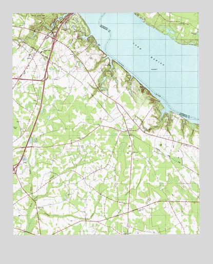
Vance, SC USGS Topographic Map
Click on map above to begin viewing in our Map Viewer.

This topographic map contains these locations and features:
Feature Name Type Latitude Longitude GNIS ID View Map
Avinger FieldAirportN33.4432°W80.4547°2650839View Map
Batchelor BranchStreamN33.3807°W80.4887°1220354View Map
Bell CemeteryCemeteryN33.4785°W80.4640°1220477View Map
Bob MarinaLocaleN33.4438°W80.3979°1242522View Map
Bull School (historical)SchoolN33.4199°W80.4134°1242540View Map
Bull StationPopulated PlaceN33.4238°W80.4051°1242541View Map
Camden Road School (historical)SchoolN33.3904°W80.4223°1242549View Map
Chapel Hill ChurchChurchN33.4899°W80.4831°1221505View Map
Church of GodChurchN33.4982°W80.4004°1248752View Map
Corinth Baptist ChurchChurchN33.3754°W80.4231°1247386View Map
Corinth Baptist Church CemeteryCemeteryN33.3750°W80.4235°2681197View Map
Dantzler - Hart CemeteryCemeteryN33.3904°W80.4840°1247484View Map
Felder CemeteryCemeteryN33.3892°W80.4164°2681201View Map
First Baptist ChurchChurchN33.4335°W80.4173°1242622View Map
Gerizim ChurchChurchN33.4299°W80.4543°1247889View Map
Gibson BaySwampN33.4354°W80.4995°1222692View Map
Goodwill-Santee ChurchChurchN33.4938°W80.3840°1245779View Map
Hinnant FarmsLocaleN33.4231°W80.3886°2635240View Map
Hope Lutheran ChurchChurchN33.4491°W80.4301°2490327View Map
Interchange 93CrossingN33.4121°W80.4993°1228313View Map
Interchange 97CrossingN33.4641°W80.4781°1228314View Map
Interchange 98CrossingN33.4854°W80.4715°1228315View Map
Kettle BranchStreamN33.3949°W80.4862°1223724View Map
Lake MarionReservoirN33.4612°W80.3849°1224315View Map
Lake Marion Christain Fellowship ChurchChurchN33.4950°W80.4919°2490329View Map
Lake Marion Golf CourseLocaleN33.4907°W80.4598°2490026View Map
Lakewood Lodge PondReservoirN33.4574°W80.4394°1238127View Map
Liberty Hill CemeteryCemeteryN33.3888°W80.4165°1223887View Map
Liberty Hill ChurchChurchN33.4213°W80.4193°1246359View Map
Live Oak ChurchChurchN33.4560°W80.4409°1246443View Map
Lodge Hall School (historical)SchoolN33.4068°W80.4523°1242681View Map
Mill CreekPopulated PlaceN33.4463°W80.4009°1242700View Map
Mill CreekStreamN33.4457°W80.3976°1224531View Map
Millers Pond Dam D-3763DamN33.4568°W80.4398°1240345View Map
MilligansPopulated PlaceN33.4607°W80.4537°1242701View Map
Mount Holly School (historical)SchoolN33.4682°W80.4668°1242710View Map
Mount Pisgah ChurchChurchN33.4929°W80.4954°1249644View Map
Oak Grove School (historical)SchoolN33.4093°W80.4979°1242739View Map
Orangeburg County Sheriff's OfficeBuildingN33.4420°W80.4227°2334916View Map
Prince Pond (historical)LakeN33.4891°W80.4031°1235998View Map
Rock Hill ChurchChurchN33.3979°W80.4637°1225929View Map
Rock Hill School (historical)SchoolN33.3977°W80.4634°1242806View Map
Sanctified ChurchChurchN33.4368°W80.4418°1242837View Map
SanteePopulated PlaceN33.4752°W80.4865°1231775View Map
Santee Baptist ChurchChurchN33.4510°W80.4837°1250782View Map
Santee Fire Department Station 1BuildingN33.4778°W80.4835°2368237View Map
Santee Golf Air Strip (historical)AirportN33.4854°W80.4573°1251965View Map
Santee Police DepartmentBuildingN33.4744°W80.4846°2334844View Map
Santee Post OfficePost OfficeN33.4841°W80.4786°2489887View Map
Santee Presbyterian ChurchChurchN33.4837°W80.4773°2490200View Map
Santee School (historical)SchoolN33.4941°W80.3843°1248763View Map
Santee Shores Pond Dam D-3746DamN33.4885°W80.4848°1240335View Map
South Carolina Noname 38020 D-3762 DamDamN33.4585°W80.4415°1238126View Map
Springfield Baptist ChurchChurchN33.4250°W80.3822°1226843View Map
Springfield CemeteryCemeteryN33.4246°W80.3820°1242860View Map
Town of SanteeCivilN33.4802°W80.4851°2407287View Map
Town of VanceCivilN33.4364°W80.4202°2406788View Map
United Holiness Church of Christ DeliverenceChurchN33.4666°W80.4918°2490207View Map
VancePopulated PlaceN33.4338°W80.4229°1231881View Map
Vance DivisionCivilN33.4354°W80.4713°1938451View Map
Vance Fire DepartmentBuildingN33.4326°W80.4280°2368141View Map
Vance Police DepartmentBuildingN33.4358°W80.4232°2334965View Map
Vance Post OfficePost OfficeN33.4361°W80.4243°2489897View Map
Vance Providence Elementary SchoolSchoolN33.4306°W80.4210°1242884View Map
Webbs CreekStreamN33.4743°W80.4345°1227454View Map

Note: Coordinates in the location and feature list above are referenced to NAD83 datum.


Copyright (C) 2008-2025 Ryan Niemi / Sunset Dynamics ... All Rights Reserved