TopoQuest Logo
Do you find TopoQuest useful?
Help keep TopoQuest running and adding new maps/features by donating!
Bitcoin:  19c7KJd3qBynnjoSw5npx9KScwjBe4ifkT
Litecoin:  LXs6TkuXGGXo1vDsWCkWVdjQX94eUKd6ui
Home View Maps Find Maps Find Places Resources & Links


Eutawville, South Carolina Topographic Map

USGS Map Title: Eutawville, SC
USGS Map MRC: 33080D3
DRG (GeoTIFF) Download: o33080d3.tif


Neighboring USGS Topographic Map Quads:


  Saint Paul, SC  
33080E4
 

  Summerton, SC  
33080E3
 

  Jordan, SC  
33080E2
 

  Vance, SC  
33080D4
 

  Eutawville, SC  
33080D3
 

  Eadytown, SC  
33080D2
 

  Holly Hill, SC  
33080C4
 

  Sandridge, SC  
33080C3
 

  Cross, SC  
33080C2


Map MRC Location:

N34°
W81°
N34°
W80°
H8 H7 H6 H5 H4 H3 H2 H1
G8 G7 G6 G5 G4 G3 G2 G1
F8 F7 F6 F5 F4 F3 F2 F1
E8 E7 E6 E5 E4 E3 E2 E1
D8 D7 D6 D5 D4 D3 D2 D1
C8 C7 C6 C5 C4 C3 C2 C1
B8 B7 B6 B5 B4 B3 B2 B1
A8 A7 A6 A5 A4 A3 A2 A1
N33°
W81°
N33°
W80°

Eutawville, SC USGS 1:24K Topographic Map Preview:
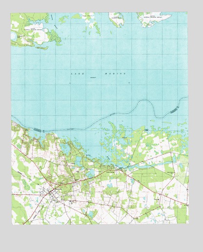
Eutawville, SC USGS Topographic Map
Click on map above to begin viewing in our Map Viewer.

This topographic map contains these locations and features:
Feature Name Type Latitude Longitude GNIS ID View Map
Black Branch School (historical)SchoolN33.4279°W80.2651°1242521View Map
Church of the Epiphany Episcopal ChurchChurchN33.4007°W80.3389°2490000View Map
Colclough PondLakeN33.4853°W80.3712°1221666View Map
Cuddo Lake (historical)LakeN33.4918°W80.2715°1235907View Map
Dorchee (historical)Populated PlaceN33.4141°W80.2901°1242596View Map
Epiphany ChurchChurchN33.3996°W80.3404°1222299View Map
Eutaw CreekStreamN33.4199°W80.3115°1247695View Map
Eutaw SpringsPopulated PlaceN33.4068°W80.3009°1247696View Map
Eutaw Springs ChurchChurchN33.4063°W80.2881°1242613View Map
EutawvillePopulated PlaceN33.3946°W80.3473°1247697View Map
Eutawville CemeteryCemeteryN33.4004°W80.3301°1222306View Map
Eutawville DivisionCivilN33.3872°W80.2995°1938263View Map
Eutawville Fire DepartmentBuildingN33.3911°W80.3434°2368371View Map
Eutawville Fire Department Gaillard Sub StationBuildingN33.3893°W80.2706°2368387View Map
Eutawville Police DepartmentBuildingN33.3956°W80.3462°2334981View Map
Eutawville Post OfficePost OfficeN33.3939°W80.3474°2489793View Map
Ferguson (historical)Populated PlaceN33.4321°W80.2804°1242618View Map
Ferguson LandingPopulated PlaceN33.4307°W80.2809°1231280View Map
Fountain LakePopulated PlaceN33.4174°W80.3265°1242629View Map
Gaillard SchoolSchoolN33.3896°W80.2712°1247857View Map
Goodwill Church (historical)ChurchN33.4824°W80.3373°1235934View Map
Green TownPopulated PlaceN33.3949°W80.3531°1706307View Map
Little BelviderePopulated PlaceN33.3996°W80.3293°1706308View Map
Mid Hill School (historical)SchoolN33.3852°W80.2984°1242697View Map
Mount Pisgah ChurchChurchN33.3863°W80.2501°1224764View Map
Nelsons Ferry (historical)CrossingN33.4307°W80.3262°1242724View Map
Pine IslandIslandN33.4793°W80.3540°1225455View Map
Possum TownPopulated PlaceN33.3888°W80.3468°1706309View Map
Red Bank LandingLocaleN33.4349°W80.3706°1242795View Map
Round IslandIslandN33.4929°W80.2759°1226042View Map
Saint James ChurchChurchN33.3888°W80.3423°1226114View Map
Saint James Gaillard Elementary SchoolSchoolN33.3889°W80.3335°1250530View Map
Saint James School (historical)SchoolN33.4077°W80.3220°1242818View Map
Saint Johns Race Track (historical)LocaleN33.4160°W80.2912°1242823View Map
Saint JulianPopulated PlaceN33.4146°W80.3601°1242824View Map
Saint Julien PlantationLocaleN33.4093°W80.3543°1706310View Map
Savanna BranchStreamN33.4888°W80.3284°1250795View Map
Silas ChurchChurchN33.3999°W80.2843°1250885View Map
Smith Hill School (historical)SchoolN33.3949°W80.2995°1242851View Map
Spring Hill ChurchChurchN33.4068°W80.2968°1226822View Map
Spring Hill School (historical)SchoolN33.4068°W80.2973°1242858View Map
Sullivan Lake (historical)LakeN33.4627°W80.3743°1236043View Map
Tabernacle ChurchChurchN33.4079°W80.3218°1251103View Map
Tancaw CreekStreamN33.4891°W80.3059°1227026View Map
Tawcaw CreekStreamN33.4796°W80.2937°1236052View Map
Town of EutawvilleCivilN33.3977°W80.3429°2406471View Map
Walnut Grove CemeteryCemeteryN33.4052°W80.2601°1227386View Map
Walnut Grove ChurchChurchN33.4054°W80.2598°1242886View Map
Walnut Grove PlantationLocaleN33.4093°W80.2584°1706311View Map
Walnut Grove School (historical)SchoolN33.4035°W80.2518°1242887View Map
Walworth CemeteryCemeteryN33.3787°W80.2871°2681248View Map
Waner Grove School (historical)SchoolN33.4029°W80.2606°1242888View Map
Wutawville Deliverance CenterChurchN33.3866°W80.3347°2490208View Map

Note: Coordinates in the location and feature list above are referenced to NAD83 datum.


Copyright (C) 2008-2025 Ryan Niemi / Sunset Dynamics ... All Rights Reserved