TopoQuest Logo
Do you find TopoQuest useful?
Help keep TopoQuest running and adding new maps/features by donating!
Bitcoin:  19c7KJd3qBynnjoSw5npx9KScwjBe4ifkT
Litecoin:  LXs6TkuXGGXo1vDsWCkWVdjQX94eUKd6ui
Home View Maps Find Maps Find Places Resources & Links


Vandalia, Michigan Topographic Map

USGS Map Title: Vandalia, MI
USGS Map MRC: 41085H8
DRG (GeoTIFF) Download: o41085h8.tif


Neighboring USGS Topographic Map Quads:


  Twin Lakes, MI  
42086A1
 

  Decatur, MI  
42085A8
 

  Marcellus, MI  
42085A7
 

  Dowagiac, MI  
41086H1
 

  Vandalia, MI  
41085H8
 

  Jones, MI  
41085H7
 

  Edwardsburg, MI  
41086G1
 

  Adamsville, MI  
41085G8
 

  Mottville, MI  
41085G7


Map MRC Location:

N42°
W86°
N42°
W85°
H8 H7 H6 H5 H4 H3 H2 H1
G8 G7 G6 G5 G4 G3 G2 G1
F8 F7 F6 F5 F4 F3 F2 F1
E8 E7 E6 E5 E4 E3 E2 E1
D8 D7 D6 D5 D4 D3 D2 D1
C8 C7 C6 C5 C4 C3 C2 C1
B8 B7 B6 B5 B4 B3 B2 B1
A8 A7 A6 A5 A4 A3 A2 A1
N41°
W86°
N41°
W85°

Vandalia, MI USGS 1:24K Topographic Map Preview:
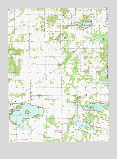
Vandalia, MI USGS Topographic Map
Click on map above to begin viewing in our Map Viewer.

This topographic map contains these locations and features:
Feature Name Type Latitude Longitude GNIS ID View Map
Allegheny SchoolSchoolN41.9548°W85.9745°619965View Map
Belas LakeLakeN41.9388°W85.8801°621022View Map
Bethel ChurchChurchN41.9695°W85.9736°621210View Map
Birch Lake CemeteryCemeteryN41.8850°W85.8856°2109370View Map
Birch Lake ChurchChurchN41.8859°W85.8847°621409View Map
Bogue Street Memorial GardenCemeteryN41.9191°W85.9129°2780848View Map
Bonine Elk ParkParkN41.9192°W85.9256°2402213View Map
Briar Patch SchoolSchoolN41.9984°W85.9144°621948View Map
BrownsvillePopulated PlaceN41.8781°W85.9542°622116View Map
Brownsville Post Office (historical)Post OfficeN41.8781°W85.9542°2402209View Map
Calvin Center Seventh Day Adventist ChurchChurchN41.8833°W85.9347°2402153View Map
Calvin Center Seventh Day Adventist SchoolSchoolN41.8833°W85.9347°2402151View Map
Camp BryanLocaleN41.9848°W85.9083°622545View Map
Camp CozyLocaleN41.8925°W85.9933°622553View Map
Camp ManitouLocaleN41.9864°W85.9042°2109378View Map
Camp MatthewsLocaleN41.9364°W85.8903°622603View Map
Cass CountyCivilN41.9154°W85.9935°1622956View Map
Diamond IslandIslandN41.9025°W85.9761°624632View Map
Diamond LakeLakeN41.9015°W85.9795°624634View Map
Diamond Lake ChurchChurchN41.9139°W85.9719°2109372View Map
Diamond Lake Golf ClubLocaleN41.9094°W85.9931°2402162View Map
Diamond ShoresPopulated PlaceN41.8981°W85.9681°624642View Map
Donnell LakeLakeN41.9074°W85.8922°624788View Map
Eagle PointPopulated PlaceN41.8953°W85.9831°625095View Map
East SchoolSchoolN41.8825°W85.8814°625255View Map
First Church of GodChurchN41.9100°W85.9994°2414419View Map
Fish Lake SchoolSchoolN41.9828°W85.8928°626046View Map
Geneva SchoolSchoolN41.9184°W85.9717°626727View Map
Gospel Lighthouse ChurchChurchN41.9164°W85.9072°2414359View Map
Kirk LakeLakeN41.9295°W85.8801°629766View Map
Lake Regional Conference CampLocaleN41.8844°W85.9361°2109371View Map
Lewis LakeLakeN41.9067°W85.8750°630350View Map
Little Fish LakeLakeN41.9848°W85.9042°630621View Map
Little Fish Lake CemeteryCemeteryN41.9847°W85.8964°2109376View Map
Long SchoolSchoolN41.8823°W85.9328°630998View Map
Maple Grove Trailer ParkPopulated PlaceN41.9300°W85.9722°2402163View Map
Moon CemeteryCemeteryN41.9147°W85.9729°632616View Map
Muld LakeLakeN41.9721°W85.9326°633096View Map
Oakdale CemeteryCemeteryN41.9258°W85.9133°2109374View Map
Paradise LakeLakeN41.8907°W85.9085°634346View Map
Park Shore ResortLocaleN41.9089°W85.9856°634376View Map
PennPopulated PlaceN41.9470°W85.9358°634587View Map
Penn Friends ChurchChurchN41.9475°W85.9347°2402154View Map
Penn Post Office (historical)Post OfficeN41.9469°W85.9358°2402193View Map
Penn StationLocaleN41.9472°W85.9342°2402192View Map
Penn Township Fire DepartmentBuildingN41.9158°W85.9139°2636068View Map
Pleasant Hill SchoolSchoolN41.9823°W85.9533°635093View Map
Pleasant View ChurchChurchN41.9181°W85.9583°2109373View Map
Prairie Grove CemeteryCemeteryN41.9330°W85.9333°2109375View Map
Spring BeachPopulated PlaceN41.9073°W85.9583°638537View Map
Stevens Memorial ParkParkN41.9875°W85.8953°2109377View Map
Township of PennCivilN41.9404°W85.9334°1626890View Map
Underground Railroad Historical MarkerParkN41.9192°W85.9256°2402214View Map
VandaliaPopulated PlaceN41.9170°W85.9147°1615496View Map
Vandalia Church of GodChurchN41.9142°W85.9092°2414357View Map
Vandalia Post OfficePost OfficeN41.9168°W85.9123°2414358View Map
Vandalia Station (historical)LocaleN41.9133°W85.9144°2414355View Map
Vandalia Village HallBuildingN41.9164°W85.9069°2414356View Map
Village of VandaliaCivilN41.9189°W85.9143°2400044View Map
WakeleePopulated PlaceN41.9839°W85.8789°1615677View Map
Wakelee Post Office (historical)Post OfficeN41.9839°W85.8789°2402172View Map
Wakelee StationLocaleN41.9858°W85.8761°2402173View Map
Wakelee United Methodist ChurchChurchN41.9836°W85.8753°2414379View Map
White Temple SchoolSchoolN41.9475°W85.9008°1616349View Map
Wildcat LakeLakeN41.9707°W85.8839°1616446View Map
WSAD-FM (Vandalia)TowerN41.9173°W85.9156°1625520View Map
Youngs Prairie CemeteryCemeteryN41.9481°W85.9703°1616907View Map

Note: Coordinates in the location and feature list above are referenced to NAD83 datum.


Copyright (C) 2008-2024 Ryan Niemi / Sunset Dynamics ... All Rights Reserved