TopoQuest Logo
Do you find TopoQuest useful?
Help keep TopoQuest running and adding new maps/features by donating!
Bitcoin:  19c7KJd3qBynnjoSw5npx9KScwjBe4ifkT
Litecoin:  LXs6TkuXGGXo1vDsWCkWVdjQX94eUKd6ui
Home View Maps Find Maps Find Places Resources & Links


Twin Lakes, Michigan Topographic Map

USGS Map Title: Twin Lakes, MI
USGS Map MRC: 42086A1
DRG (GeoTIFF) Download: o42086a1.tif


Neighboring USGS Topographic Map Quads:


  Hartford, MI  
42086B2
 

  Lawrence, MI  
42086B1
 

  Paw Paw, MI  
42085B8
 

  Sister Lakes, MI  
42086A2
 

  Twin Lakes, MI  
42086A1
 

  Decatur, MI  
42085A8
 

  Sumnerville, MI  
41086H2
 

  Dowagiac, MI  
41086H1
 

  Vandalia, MI  
41085H8


Map MRC Location:

N43°
W87°
N43°
W86°
H8 H7 H6 H5 H4 H3 H2 H1
G8 G7 G6 G5 G4 G3 G2 G1
F8 F7 F6 F5 F4 F3 F2 F1
E8 E7 E6 E5 E4 E3 E2 E1
D8 D7 D6 D5 D4 D3 D2 D1
C8 C7 C6 C5 C4 C3 C2 C1
B8 B7 B6 B5 B4 B3 B2 B1
A8 A7 A6 A5 A4 A3 A2 A1
N42°
W87°
N42°
W86°

Twin Lakes, MI USGS 1:24K Topographic Map Preview:
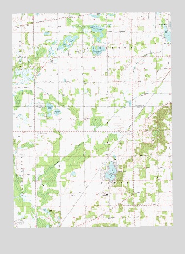
Twin Lakes, MI USGS Topographic Map
Click on map above to begin viewing in our Map Viewer.

This topographic map contains these locations and features:
Feature Name Type Latitude Longitude GNIS ID View Map
Bell SchoolSchoolN42.0848°W86.0953°621042View Map
Celery Center SchoolSchoolN42.0828°W86.0347°622962View Map
Code SchoolSchoolN42.0995°W86.0047°1623730View Map
Cook LakeLakeN42.0100°W86.0997°623757View Map
Field SchoolSchoolN42.0853°W86.0706°1623733View Map
Five Mile CornersPopulated PlaceN42.0561°W86.1075°2109319View Map
Five Mile Drive In TheaterLocaleN42.0564°W86.1117°2414312View Map
Four Winds Fellowship ChurchChurchN42.0989°W86.0350°2574947View Map
Gage CemeteryCemeteryN42.0194°W86.0792°2109317View Map
Gage SchoolSchoolN42.0203°W86.0706°626589View Map
Geer LakeLakeN42.0702°W86.0962°626702View Map
GlenwoodPopulated PlaceN42.0550°W86.0331°626890View Map
Glenwood Post Office (historical)Post OfficeN42.0550°W86.0331°2402200View Map
Glenwood Seventh Day Adventist ChurchChurchN42.0547°W86.0306°2414336View Map
Glenwood StationLocaleN42.0556°W86.0350°2402199View Map
Glenwood Union Seventh Day Adventist SchoolSchoolN42.0528°W86.0306°2414322View Map
Hamilton CemeteryCemeteryN42.1244°W86.0597°2574952View Map
Hamilton ChapelChurchN42.0844°W86.0692°2112896View Map
Hamilton Grange Hall Historical MarkerParkN42.1136°W86.0503°2570906View Map
Hayden SchoolSchoolN42.1225°W86.0903°627979View Map
Kirkwood SchoolSchoolN42.0264°W86.0114°629771View Map
Knickerbocker LakeLakeN42.1032°W86.0575°629683View Map
Lake of the Woods DrainStreamN42.0728°W86.0350°1623467View Map
North Wayne CemeteryCemeteryN42.0633°W86.0692°2109320View Map
North Wayne Mennonite ChurchChurchN42.0633°W86.0936°2414328View Map
North Wayne SchoolSchoolN42.0623°W86.0931°633672View Map
Oak Shores CampgroundLocaleN42.1061°W86.0500°2574948View Map
Old Past Church of ChristChurchN42.1228°W86.1131°2379262View Map
Old Path Church of God in ChristChurchN42.1231°W86.1133°2379263View Map
Osborn DrainCanalN42.0778°W86.0983°634123View Map
Osborn LakeLakeN42.1026°W86.0700°634125View Map
Phelps Mobile Home ParkPopulated PlaceN42.0967°W86.0958°2574949View Map
Pine LakeLakeN42.1054°W86.0808°634954View Map
Pine LakeLakeN42.0002°W86.0988°634971View Map
Pitcher LakeLakeN42.0674°W86.0901°635050View Map
Pitcher Lake CampgroundLocaleN42.0658°W86.0922°2414349View Map
Red Mill CemeteryCemeteryN42.0421°W86.1182°2109318View Map
Round LakeLakeN42.0659°W86.0963°636278View Map
Rowlee SchoolSchoolN42.1137°W86.0403°636346View Map
School LakeLakeN42.1145°W86.0582°637373View Map
Timber Trails RV ParkLocaleN42.1078°W86.0067°2574946View Map
Township of HamiltonCivilN42.1136°W86.0500°1626423View Map
Township of WayneCivilN42.0279°W86.0484°1627233View Map
Twin LakesPopulated PlaceN42.0306°W86.0450°2109316View Map
Twin LakesLakeN42.0340°W86.0473°1615251View Map
Wayne Township Fire DepartmentBuildingN42.0129°W86.0310°2414319View Map
White CemeteryCemeteryN42.0055°W86.0292°2109315View Map
White SchoolSchoolN42.0056°W86.0317°1616337View Map

Note: Coordinates in the location and feature list above are referenced to NAD83 datum.


Copyright (C) 2008-2024 Ryan Niemi / Sunset Dynamics ... All Rights Reserved