TopoQuest Logo
Do you find TopoQuest useful?
Help keep TopoQuest running and adding new maps/features by donating!
Bitcoin:  19c7KJd3qBynnjoSw5npx9KScwjBe4ifkT
Litecoin:  LXs6TkuXGGXo1vDsWCkWVdjQX94eUKd6ui
Home View Maps Find Maps Find Places Resources & Links


Veneta, Oregon Topographic Map

USGS Map Title: Veneta, OR
USGS Map MRC: 44123A3
DRG (GeoTIFF) Download: o44123a3.tif


Neighboring USGS Topographic Map Quads:


  Horton, OR  
44123B4
 

  Cheshire, OR  
44123B3
 

  Junction City, OR  
44123B2
 

  Noti, OR  
44123A4
 

  Veneta, OR  
44123A3
 

  Eugene West, OR  
44123A2
 

  High Point, OR  
43123H4
 

  Crow, OR  
43123H3
 

  Fox Hollow, OR  
43123H2


Map MRC Location:

N45°
W124°
N45°
W123°
H8 H7 H6 H5 H4 H3 H2 H1
G8 G7 G6 G5 G4 G3 G2 G1
F8 F7 F6 F5 F4 F3 F2 F1
E8 E7 E6 E5 E4 E3 E2 E1
D8 D7 D6 D5 D4 D3 D2 D1
C8 C7 C6 C5 C4 C3 C2 C1
B8 B7 B6 B5 B4 B3 B2 B1
A8 A7 A6 A5 A4 A3 A2 A1
N44°
W124°
N44°
W123°

Veneta, OR USGS 1:24K Topographic Map Preview:
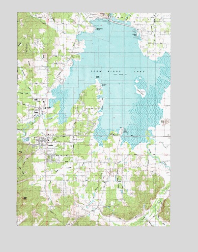
Veneta, OR USGS Topographic Map
Click on map above to begin viewing in our Map Viewer.

This topographic map contains these locations and features:
Feature Name Type Latitude Longitude GNIS ID View Map
Applegate Pioneer MuseumBuildingN44.0635°W123.3258°2661593View Map
Bethany Church of Franklin OregonChurchN44.0847°W123.3428°2508139View Map
Bolton HillSummitN44.0415°W123.3720°1135352View Map
Cardiff (historical)LocaleN44.0526°W123.3415°1166297View Map
Central CemeteryCemeteryN44.0314°W123.3027°1135354View Map
Central Elementary School (historical)SchoolN44.0258°W123.3036°1118788View Map
City of VenetaCivilN44.0471°W123.3513°2412148View Map
Countryside Seventh Day Adventist SchoolSchoolN44.0575°W123.3297°2462989View Map
Coyote CreekStreamN44.0573°W123.2745°1158184View Map
Davis ReservoirReservoirN44.0148°W123.2718°1130666View Map
Demming RidgeRidgeN44.0985°W123.3693°1135360View Map
ElmiraPopulated PlaceN44.0657°W123.3554°1136259View Map
Elmira Church of ChristChurchN44.0686°W123.3583°2508153View Map
Elmira Elementary SchoolSchoolN44.0725°W123.3541°1162212View Map
Elmira High SchoolSchoolN44.0738°W123.3607°1162211View Map
Elmira Post OfficePost OfficeN44.0670°W123.3549°1165211View Map
Eugene Yacht ClubLocaleN44.1165°W123.3112°1163706View Map
Fern RidgeRidgeN44.1143°W123.2654°1120677View Map
Fern Ridge DamDamN44.1204°W123.2995°1130660View Map
Fern Ridge LakeReservoirN44.0896°W123.2992°1120678View Map
Fern Ridge LibraryBuildingN44.0467°W123.3521°2661044View Map
Fern Ridge Middle SchoolSchoolN44.0690°W123.3534°1128415View Map
Fern Ridge ShoresPopulated PlaceN44.0818°W123.3082°1135359View Map
Fern Ridge Shores RV Park Boat RampLocaleN44.0803°W123.3062°2668368View Map
Fisher ButteSummitN44.0610°W123.2537°1136289View Map
Gibson IslandIslandN44.0790°W123.2740°1121124View Map
Griffith ReservoirReservoirN44.0201°W123.2905°1130665View Map
Hannavan CreekStreamN44.0760°W123.3437°1121564View Map
Indian CreekStreamN44.0557°W123.3695°1122215View Map
Inman CemeteryCemeteryN44.1075°W123.3258°1122259View Map
Inman CreekStreamN44.1107°W123.3254°1122260View Map
Jetson (historical)LocaleN44.0526°W123.2609°1130661View Map
Job Swale CreekStreamN44.0465°W123.3104°1130663View Map
Krugur ParkParkN44.1210°W123.3107°1122844View Map
Lane County Fire District 1 Station 101BuildingN44.0477°W123.3523°2576638View Map
Lane County Fire District 1 Station 102BuildingN44.0374°W123.2961°2576977View Map
Lane County Fire District 1 Station 105BuildingN44.0677°W123.3583°2577154View Map
Lane County Public Works Shop Zone 2BuildingN44.0549°W123.3386°2661385View Map
Lane County Public Works Shop Zone 4BuildingN44.1190°W123.3201°2661326View Map
Lane Transit District Park and RideLocaleN44.0550°W123.3532°2668522View Map
Llewellyn Post Office (historical)Post OfficeN44.0415°W123.2693°1165551View Map
MaywoodLocaleN44.0543°W123.2993°1166676View Map
Middle Fork Coyote CreekStreamN44.0457°W123.2831°1130664View Map
Mounse BurialCemeteryN44.0122°W123.3419°1135355View Map
Oak Island ParkParkN44.0360°W123.3484°1135357View Map
Olivet Baptist ChurchChurchN44.0500°W123.3531°2508156View Map
Orchard PointCapeN44.1123°W123.2776°1135363View Map
Orchard Point County ParkParkN44.1123°W123.2773°1125014View Map
Orchard Point ParkHarborN44.1148°W123.2800°2668575View Map
Orchard Point Park Boat RampLocaleN44.1154°W123.2803°2668278View Map
Parker CreekStreamN44.0782°W123.3651°1130713View Map
Perkins Mill (historical)LocaleN44.0554°W123.2887°1162682View Map
Perkins PeninsulaCapeN44.0568°W123.2901°1135356View Map
Perkins Peninsula County ParkParkN44.0560°W123.2898°1125303View Map
Perkins Penninsula Boat RampLocaleN44.0544°W123.2898°2668464View Map
Richardson CemeteryCemeteryN44.1237°W123.3048°1135361View Map
Richardson County ParkParkN44.1179°W123.3145°1125984View Map
Richardson ParkHarborN44.1160°W123.3117°2668114View Map
Richardson Park Boat RampLocaleN44.1175°W123.3146°2668349View Map
Richardson PointCapeN44.1165°W123.3123°1135362View Map
Rocky ButteSummitN44.0152°W123.3707°1135353View Map
Saint Thomas Becket AcademySchoolN44.0419°W123.3433°2463032View Map
Signal IslandIslandN44.0879°W123.3084°1130659View Map
Spencer CreekStreamN44.0104°W123.2631°1127385View Map
Union High School (historical)SchoolN44.0687°W123.3523°2563882View Map
VenetaPopulated PlaceN44.0487°W123.3509°1136867View Map
Veneta City HallBuildingN44.0513°W123.3608°2661591View Map
Veneta Elementary SchoolSchoolN44.0498°W123.3505°2463034View Map
Veneta Municipal CourtBuildingN44.0513°W123.3608°2661611View Map
Veneta Post OfficePost OfficeN44.0501°W123.3525°1166099View Map
Veneta Wastewater Treatment FacilityLocaleN44.0502°W123.3687°2660684View Map
Veneta Water TreatmentLocaleN44.0507°W123.3452°2660776View Map
Veneta WellheadLocaleN44.0498°W123.3309°2660743View Map
Warren SloughSwampN44.0498°W123.2782°1130667View Map
West Fork Coyote CreekStreamN44.0448°W123.3109°1130662View Map
Zumwalt County ParkParkN44.0640°W123.3068°1162213View Map

Note: Coordinates in the location and feature list above are referenced to NAD83 datum.


Copyright (C) 2008-2024 Ryan Niemi / Sunset Dynamics ... All Rights Reserved