TopoQuest Logo
Do you find TopoQuest useful?
Help keep TopoQuest running and adding new maps/features by donating!
Bitcoin:  19c7KJd3qBynnjoSw5npx9KScwjBe4ifkT
Litecoin:  LXs6TkuXGGXo1vDsWCkWVdjQX94eUKd6ui
Home View Maps Find Maps Find Places Resources & Links


High Point, Oregon Topographic Map

USGS Map Title: High Point, OR
USGS Map MRC: 43123H4
DRG (GeoTIFF) Download: o43123h4.tif


Neighboring USGS Topographic Map Quads:


  Walton, OR  
44123A5
 

  Noti, OR  
44123A4
 

  Veneta, OR  
44123A3
 

  Clay Creek, OR  
43123H5
 

  High Point, OR  
43123H4
 

  Crow, OR  
43123H3
 

  Gunter, OR  
43123G5
 

  Beaver Creek, OR  
43123G4
 

  Letz Creek, OR  
43123G3


Map MRC Location:

N44°
W124°
N44°
W123°
H8 H7 H6 H5 H4 H3 H2 H1
G8 G7 G6 G5 G4 G3 G2 G1
F8 F7 F6 F5 F4 F3 F2 F1
E8 E7 E6 E5 E4 E3 E2 E1
D8 D7 D6 D5 D4 D3 D2 D1
C8 C7 C6 C5 C4 C3 C2 C1
B8 B7 B6 B5 B4 B3 B2 B1
A8 A7 A6 A5 A4 A3 A2 A1
N43°
W124°
N43°
W123°

High Point, OR USGS 1:24K Topographic Map Preview:
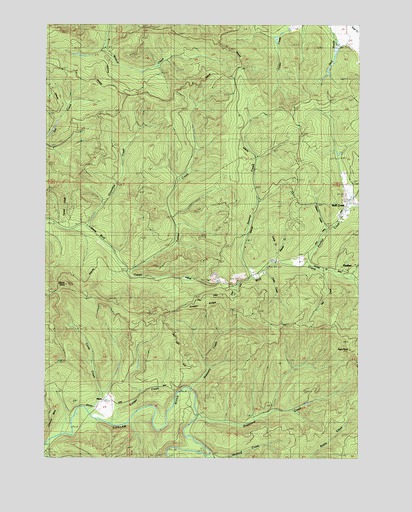
High Point, OR USGS Topographic Map
Click on map above to begin viewing in our Map Viewer.

This topographic map contains these locations and features:
Feature Name Type Latitude Longitude GNIS ID View Map
AlmaPopulated PlaceN43.8910°W123.4748°1116888View Map
Alma Post Office (historical)Post OfficeN43.8910°W123.4748°1164824View Map
Beaver CreekStreamN43.9318°W123.4095°1130871View Map
Cabin CreekStreamN43.9290°W123.4137°1130867View Map
Camp CreekStreamN43.8885°W123.4840°1118500View Map
Carrol ReservoirReservoirN43.9946°W123.3850°1130840View Map
Conger CreekStreamN43.8840°W123.4737°1119200View Map
Deer CreekStreamN43.9248°W123.4262°1130866View Map
Dogwood CreekStreamN43.8860°W123.4412°1120019View Map
Eames CreekStreamN43.9279°W123.4673°1120274View Map
Elkhorn CreekStreamN43.9404°W123.3912°1120471View Map
Fish CreekStreamN43.9285°W123.3909°1130868View Map
Greenshaw CreekStreamN43.9415°W123.4854°1121413View Map
High PointSummitN43.9062°W123.3797°1121810View Map
Holland CreekStreamN43.8762°W123.4359°1130864View Map
Lane County Fire District 1 Station 18 - 2BuildingN43.9497°W123.3801°2576762View Map
Lane County Forest Work CampBuildingN43.8892°W123.4767°2722766View Map
Letsom MountainSummitN43.8867°W123.4988°1134545View Map
Lewis CreekStreamN43.9346°W123.4090°1130872View Map
Mound (historical)Populated PlaceN43.8943°W123.4512°1130869View Map
Mound Post Office (historical)Post OfficeN43.8943°W123.4512°1165668View Map
Panther (historical)LocaleN43.9290°W123.3845°1130874View Map
Panther CreekStreamN43.9315°W123.3993°1125165View Map
Panther Post Office (historical)Post OfficeN43.9290°W123.3845°1165759View Map
Pheasant CreekStreamN43.8943°W123.4437°1125339View Map
Stony PointCapeN43.9246°W123.4929°1127637View Map
Swamp CreekStreamN43.9273°W123.4204°1127787View Map
Timber RidgeRidgeN43.9185°W123.4318°1130870View Map
Tunnel CreekStreamN43.9421°W123.4973°1130873View Map
Upper Siuslaw River DivisionCivilN43.9090°W123.4266°1938142View Map
Wolf CreekPopulated PlaceN43.9498°W123.3790°1130854View Map
Wolf Creek StoreLocaleN43.9498°W123.3809°1129280View Map

Note: Coordinates in the location and feature list above are referenced to NAD83 datum.


Copyright (C) 2008-2024 Ryan Niemi / Sunset Dynamics ... All Rights Reserved