TopoQuest Logo
Do you find TopoQuest useful?
Help keep TopoQuest running and adding new maps/features by donating!
Bitcoin:  19c7KJd3qBynnjoSw5npx9KScwjBe4ifkT
Litecoin:  LXs6TkuXGGXo1vDsWCkWVdjQX94eUKd6ui
Home View Maps Find Maps Find Places Resources & Links


Vernon, Florida Topographic Map

USGS Map Title: Vernon, FL
USGS Map MRC: 30085E6
DRG (GeoTIFF) Download: o30085e6.tif


Neighboring USGS Topographic Map Quads:


  Hinsons Crossroads, FL  
30085F7
 

  Poplar Head, FL  
30085F6
 

  Wausau, FL  
30085F5
 

  Millers Ferry, FL  
30085E7
 

  Vernon, FL  
30085E6
 

  Gap Lake, FL  
30085E5
 

  Red Head, FL  
30085D7


Map MRC Location:

N31°
W86°
N31°
W85°
H8 H7 H6 H5 H4 H3 H2 H1
G8 G7 G6 G5 G4 G3 G2 G1
F8 F7 F6 F5 F4 F3 F2 F1
E8 E7 E6 E5 E4 E3 E2 E1
D8 D7 D6 D5 D4 D3 D2 D1
C8 C7 C6 C5 C4 C3 C2 C1
B8 B7 B6 B5 B4 B3 B2 B1
A8 A7 A6 A5 A4 A3 A2 A1
N30°
W86°
N30°
W85°

Vernon, FL USGS 1:24K Topographic Map Preview:
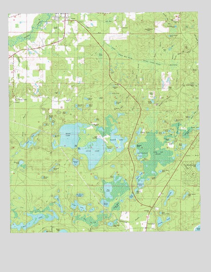
Vernon, FL USGS Topographic Map
Click on map above to begin viewing in our Map Viewer.

This topographic map contains these locations and features:
Feature Name Type Latitude Longitude GNIS ID View Map
Abigail ChurchChurchN30.6041°W85.7399°277663View Map
Altha Public SchoolSchoolN30.5732°W85.6263°297289View Map
Bait LakeLakeN30.5002°W85.7272°297381View Map
Baptizing PondLakeN30.5836°W85.6808°278090View Map
Bear Hammock LakesLakeN30.5430°W85.6644°278318View Map
Black PondLakeN30.5167°W85.6875°278932View Map
Black PondLakeN30.5723°W85.6984°278934View Map
Blackhole PondLakeN30.5469°W85.6839°278953View Map
Blue BaySwampN30.5789°W85.6561°279009View Map
Boggy BranchStreamN30.5046°W85.6963°279160View Map
Boggy PondSwampN30.5764°W85.6906°279181View Map
Bonnet PondLakeN30.5647°W85.7226°279227View Map
Bowen LakeLakeN30.5314°W85.6649°279287View Map
Buck Bend LakeLakeN30.5345°W85.6509°279552View Map
Carter BranchStreamN30.5935°W85.6399°280082View Map
Chain LakeLakeN30.5145°W85.7049°287576View Map
Cindy HoleLakeN30.5300°W85.6590°280461View Map
City of VernonCivilN30.6197°W85.7062°2405642View Map
Clair PondLakeN30.5760°W85.6273°280476View Map
Cox PondLakeN30.5618°W85.7265°280964View Map
Crooked PondLakeN30.5572°W85.6447°281077View Map
Cypress PondLakeN30.5723°W85.7051°280052View Map
Deep Edge PondLakeN30.5047°W85.6841°281425View Map
Dip Vat BranchStreamN30.5671°W85.6524°281582View Map
Ditch PondLakeN30.5564°W85.6485°281596View Map
Dog LakeLakeN30.5168°W85.7177°281657View Map
Double Branch PondLakeN30.5847°W85.6290°281702View Map
Double PondsLakeN30.5792°W85.6826°281713View Map
Dry LakeLakeN30.5238°W85.6852°281799View Map
Dry PondLakeN30.5622°W85.7212°281800View Map
Dunford LakeLakeN30.5559°W85.6820°281869View Map
Dykes Mill PondLakeN30.5146°W85.6799°281910View Map
Ebenezer ChurchChurchN30.5757°W85.7099°282065View Map
Fanning BranchStreamN30.6066°W85.7483°282376View Map
Florida Department of Corrections Northwest Florida Reception CenterBuildingN30.5205°W85.6596°2753069View Map
Florida Department of Corrections Northwest Florida Reception Center AnnexBuildingN30.5204°W85.6569°2753070View Map
Gap BranchStreamN30.5674°W85.6758°282904View Map
Gator HoleLakeN30.5653°W85.6318°282979View Map
Gin BranchStreamN30.5641°W85.6808°283087View Map
Grassy LakeLakeN30.5058°W85.6512°283326View Map
Graveyard PondLakeN30.5526°W85.6441°283352View Map
Green LakeLakeN30.5297°W85.6787°283389View Map
GreenheadPopulated PlaceN30.5046°W85.6599°295323View Map
Greenhead BranchStreamN30.5130°W85.6788°283414View Map
Greenhead CemeteryCemeteryN30.5116°W85.6583°283415View Map
Greenhead SchoolSchoolN30.5030°W85.6708°283416View Map
Gum PondSwampN30.6001°W85.6891°283542View Map
Hays Maltsby BaySwampN30.6147°W85.6572°283841View Map
Hicks LakeLakeN30.5555°W85.7101°283977View Map
Holmes ValleyPopulated PlaceN30.5769°W85.7430°295354View Map
Holmes Valley SwampSwampN30.5966°W85.6552°284193View Map
Homestead PondLakeN30.5215°W85.7040°284217View Map
Horselot PondLakeN30.5490°W85.6685°284293View Map
Hudson BranchStreamN30.5974°W85.6422°284371View Map
Hudson HillSummitN30.5707°W85.6810°284374View Map
Hudson PondLakeN30.5738°W85.6798°284380View Map
Jane BaySwampN30.6166°W85.6329°284721View Map
Joiner LakeLakeN30.5204°W85.6701°284896View Map
Kersey BranchStreamN30.5521°W85.7419°286024View Map
Little Grassy PondLakeN30.5107°W85.6510°285698View Map
Little Spring LakeLakeN30.5205°W85.6348°285828View Map
Long LakeLakeN30.5525°W85.7360°286022View Map
Lucas LakeLakeN30.5459°W85.6946°286190View Map
MacomPopulated PlaceN30.5785°W85.6310°301621View Map
Martin LakeLakeN30.5237°W85.6670°286472View Map
Massalene SchoolSchoolN30.5135°W85.6541°286506View Map
McDaniel LakeLakeN30.5277°W85.6636°286599View Map
Mitchell BranchStreamN30.5688°W85.6530°287001View Map
Moss Hill ChurchChurchN30.5844°W85.6774°287173View Map
Moss PondLakeN30.5643°W85.6931°287178View Map
Mud SwampSwampN30.5950°W85.6420°287431View Map
Mule PondLakeN30.5484°W85.6354°287448View Map
North Bonnet PondLakeN30.6168°W85.6397°287788View Map
Old BaySwampN30.6193°W85.6842°288076View Map
Otter PondLakeN30.5684°W85.7122°288291View Map
Palmer BranchStreamN30.5982°W85.6549°288425View Map
Parish PondLakeN30.5763°W85.6989°288495View Map
Payne LakeLakeN30.5572°W85.6646°288597View Map
Pine Log LakeLakeN30.5594°W85.6394°288906View Map
Pine Log SwampSwampN30.5445°W85.6544°288908View Map
Pippin Mill SwampSwampN30.6000°W85.6729°288989View Map
Potter CemeteryCemeteryN30.5730°W85.6533°289264View Map
Potter PondLakeN30.5744°W85.6554°289266View Map
Rattlesnake HeadValleyN30.6035°W85.6329°289490View Map
Roach BranchStreamN30.5974°W85.6647°289762View Map
Roach LakeLakeN30.5205°W85.6452°289766View Map
Rocky HeadValleyN30.6036°W85.6331°289905View Map
Russ PondLakeN30.5045°W85.7417°290070View Map
Shiloh ChurchChurchN30.6202°W85.7035°291040View Map
Shumold LakeLakeN30.5400°W85.7427°291091View Map
SmyrnaPopulated PlaceN30.5999°W85.6780°300953View Map
South Bonnet PondLakeN30.6115°W85.6438°291348View Map
Spring HollowBasinN30.5919°W85.6294°291544View Map
Stewart LakeLakeN30.5403°W85.7065°291695View Map
Sweetwater LakeLakeN30.5563°W85.6330°291956View Map
SylvaniaPopulated PlaceN30.6169°W85.6747°295665View Map
Sylvania ChurchChurchN30.6135°W85.6708°294446View Map
Tanyard PondLakeN30.5367°W85.7220°292028View Map
Tea PondLakeN30.5627°W85.6483°292083View Map
The Black HolesLakeN30.5611°W85.6947°294228View Map
Thorny Head BranchStreamN30.5969°W85.6408°292235View Map
Thrasher Nest PondLakeN30.5632°W85.6406°292240View Map
Tiller BaySwampN30.6031°W85.6472°292296View Map
Tiller CemeteryCemeteryN30.5510°W85.6438°292298View Map
Tiller PondLakeN30.5505°W85.6427°292300View Map
VernonPopulated PlaceN30.6230°W85.7122°292758View Map
Vernon DivisionCivilN30.5526°W85.6482°1935961View Map
Vernon Post OfficePost OfficeN30.6223°W85.7117°2783363View Map
Vernon SchoolSchoolN30.6138°W85.7127°292759View Map
Washington CountyCivilN30.6106°W85.6653°295762View Map
Washington County Ambulance ServiceBuildingN30.6116°W85.6934°2661720View Map
Weaver HillSummitN30.6191°W85.6385°292965View Map
Windsor PondLakeN30.5317°W85.7282°293406View Map

Note: Coordinates in the location and feature list above are referenced to NAD83 datum.


Copyright (C) 2008-2024 Ryan Niemi / Sunset Dynamics ... All Rights Reserved