TopoQuest Logo
Do you find TopoQuest useful?
Help keep TopoQuest running and adding new maps/features by donating!
Bitcoin:  19c7KJd3qBynnjoSw5npx9KScwjBe4ifkT
Litecoin:  LXs6TkuXGGXo1vDsWCkWVdjQX94eUKd6ui
Home View Maps Find Maps Find Places Resources & Links


Wausau, Florida Topographic Map

USGS Map Title: Wausau, FL
USGS Map MRC: 30085F5
DRG (GeoTIFF) Download: o30085f5.tif


Neighboring USGS Topographic Map Quads:


  Bonifay, FL  
30085G6
 

  Chipley, FL  
30085G5
 

  Cottondale West, FL  
30085G4
 

  Poplar Head, FL  
30085F6
 

  Wausau, FL  
30085F5
 

  Alford, FL  
30085F4
 

  Vernon, FL  
30085E6
 

  Gap Lake, FL  
30085E5
 

  Compass Lake, FL  
30085E4


Map MRC Location:

N31°
W86°
N31°
W85°
H8 H7 H6 H5 H4 H3 H2 H1
G8 G7 G6 G5 G4 G3 G2 G1
F8 F7 F6 F5 F4 F3 F2 F1
E8 E7 E6 E5 E4 E3 E2 E1
D8 D7 D6 D5 D4 D3 D2 D1
C8 C7 C6 C5 C4 C3 C2 C1
B8 B7 B6 B5 B4 B3 B2 B1
A8 A7 A6 A5 A4 A3 A2 A1
N30°
W86°
N30°
W85°

Wausau, FL USGS 1:24K Topographic Map Preview:
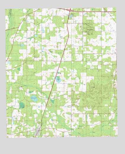
Wausau, FL USGS Topographic Map
Click on map above to begin viewing in our Map Viewer.

This topographic map contains these locations and features:
Feature Name Type Latitude Longitude GNIS ID View Map
Alex BaySwampN30.7069°W85.5637°277738View Map
Bells MillPopulated PlaceN30.6621°W85.5747°295125View Map
Bells Mill PondLakeN30.6474°W85.5785°297762View Map
Blue LakeLakeN30.7427°W85.5504°279041View Map
Blue Lake ChurchChurchN30.7446°W85.5502°279043View Map
BradfordPopulated PlaceN30.6552°W85.5516°294691View Map
Bradford PondLakeN30.6268°W85.5534°279316View Map
Brock Mill BranchStreamN30.7224°W85.6216°279429View Map
Brooks BaySwampN30.6540°W85.6230°279439View Map
Cobb BaySwampN30.6875°W85.5657°280593View Map
Cobb Bay PondLakeN30.6885°W85.5656°297761View Map
Corbin PondLakeN30.6546°W85.6074°280824View Map
Davis BranchStreamN30.6366°W85.5130°281318View Map
Double Pond ChurchChurchN30.6321°W85.5524°281711View Map
Duck PondLakeN30.6731°W85.5275°281824View Map
Earnest Owen PondLakeN30.7227°W85.5772°298255View Map
Everett CemeteryCemeteryN30.6760°W85.5355°282291View Map
Falling WaterFallsN30.7244°W85.5297°282368View Map
Falling Water HillSummitN30.7313°W85.5352°282369View Map
Falling Waters State ParkParkN30.7280°W85.5285°303998View Map
Flat CreekStreamN30.6769°W85.5991°282558View Map
Flat Creek ChurchChurchN30.7124°W85.5169°282560View Map
Gainer LakeSwampN30.6812°W85.5661°282869View Map
Hamm BaySwampN30.7489°W85.5977°283645View Map
Hard Labor ChurchChurchN30.6752°W85.6085°283723View Map
Harper CreekSwampN30.6458°W85.5006°283753View Map
Hartzog FieldAirportN30.7189°W85.6067°2676708View Map
Jones Rice Mill BranchStreamN30.7244°W85.6074°297661View Map
Lake L RanchoLakeN30.7149°W85.6061°298239View Map
Little Hard Labor CreekStreamN30.6316°W85.5174°294057View Map
Mercer BaySwampN30.7084°W85.5734°286717View Map
Mercer PondLakeN30.6622°W85.5436°286719View Map
New Home ChurchChurchN30.7030°W85.5927°287620View Map
Oak Grove SchoolSchoolN30.6644°W85.5852°287961View Map
Orange HillSummitN30.6694°W85.5155°288203View Map
Orange Hill AirportAirportN30.6609°W85.5269°309954View Map
Orange Hill ChurchChurchN30.6888°W85.5219°288207View Map
Orange Hill CornersLocaleN30.6949°W85.5005°288208View Map
Owens LakeLakeN30.6630°W85.5934°288311View Map
Piney Grove ChurchChurchN30.7035°W85.5924°288950View Map
Potter BranchStreamN30.6955°W85.5535°289263View Map
Reedy CreekStreamN30.6516°W85.5766°289612View Map
Saint Joseph SchoolSchoolN30.6694°W85.5513°290250View Map
Sand Hill BaySwampN30.7152°W85.6060°290522View Map
Shiloh ChurchChurchN30.7432°W85.5994°291041View Map
Smutty BaySwampN30.7230°W85.5652°291274View Map
Street BranchStreamN30.6549°W85.6188°291746View Map
Take in SwampSwampN30.6358°W85.5419°291994View Map
Town of WausauCivilN30.6335°W85.5872°2406841View Map
WausauPopulated PlaceN30.6321°W85.5888°292952View Map
Wausau Post OfficePost OfficeN30.6310°W85.5898°2783441View Map
Wausau Volunteer Fire DepartmentBuildingN30.6299°W85.5889°2644202View Map
WTBB-FM (Bonifay)TowerN30.6994°W85.6208°308955View Map

Note: Coordinates in the location and feature list above are referenced to NAD83 datum.


Copyright (C) 2008-2024 Ryan Niemi / Sunset Dynamics ... All Rights Reserved