TopoQuest Logo
Do you find TopoQuest useful?
Help keep TopoQuest running and adding new maps/features by donating!
Bitcoin:  19c7KJd3qBynnjoSw5npx9KScwjBe4ifkT
Litecoin:  LXs6TkuXGGXo1vDsWCkWVdjQX94eUKd6ui
Home View Maps Find Maps Find Places Resources & Links


Millers Ferry, Florida Topographic Map

USGS Map Title: Millers Ferry, FL
USGS Map MRC: 30085E7
DRG (GeoTIFF) Download: o30085e7.tif


Neighboring USGS Topographic Map Quads:


  Ponce de Leon, FL  
30085F8
 

  Hinsons Crossroads, FL  
30085F7
 

  Poplar Head, FL  
30085F6
 

  Redbay, FL  
30085E8
 

  Millers Ferry, FL  
30085E7
 

  Vernon, FL  
30085E6


  Red Head, FL  
30085D7


Map MRC Location:

N31°
W86°
N31°
W85°
H8 H7 H6 H5 H4 H3 H2 H1
G8 G7 G6 G5 G4 G3 G2 G1
F8 F7 F6 F5 F4 F3 F2 F1
E8 E7 E6 E5 E4 E3 E2 E1
D8 D7 D6 D5 D4 D3 D2 D1
C8 C7 C6 C5 C4 C3 C2 C1
B8 B7 B6 B5 B4 B3 B2 B1
A8 A7 A6 A5 A4 A3 A2 A1
N30°
W86°
N30°
W85°

Millers Ferry, FL USGS 1:24K Topographic Map Preview:
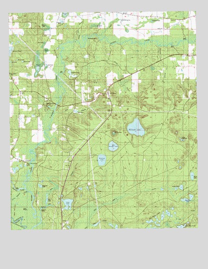
Millers Ferry, FL USGS Topographic Map
Click on map above to begin viewing in our Map Viewer.

This topographic map contains these locations and features:
Feature Name Type Latitude Longitude GNIS ID View Map
Anderson PondLakeN30.6195°W85.7793°277862View Map
Bear Bay CreekStreamN30.5030°W85.8224°278288View Map
Bear RidgeSummitN30.5119°W85.8658°278346View Map
Big Brushy LakeLakeN30.5477°W85.8063°294612View Map
Black HammockIslandN30.5110°W85.8724°278895View Map
Black LakeLakeN30.5303°W85.7537°278933View Map
Bob Russ LakesLakeN30.5074°W85.7737°304711View Map
Bonnet LakeLakeN30.5958°W85.8557°279228View Map
Boynton CutoffChannelN30.5235°W85.8708°279305View Map
Brink Hill SchoolSchoolN30.5974°W85.8110°279405View Map
Bryant PondLakeN30.5973°W85.8660°279539View Map
Bunker DonationPopulated PlaceN30.5313°W85.8694°307110View Map
Chapel BranchStreamN30.6124°W85.8160°280301View Map
Cravy LakesLakeN30.5235°W85.7618°281010View Map
Cypress PondLakeN30.5895°W85.8336°281232View Map
Deep Edge LakeLakeN30.5155°W85.7570°281426View Map
Dunn-Raley CemeteryCemeteryN30.5899°W85.8741°281878View Map
Evans PondSwampN30.6035°W85.8500°282282View Map
Evans SloughGutN30.6030°W85.8433°282285View Map
Fortune LakeLakeN30.6247°W85.8376°282718View Map
Henry Lee PondLakeN30.5255°W85.8552°283914View Map
Hogpen PondSwampN30.6172°W85.8182°284125View Map
Jim PondLakeN30.6067°W85.8519°284807View Map
Kolmetz PondLakeN30.6033°W85.8741°285175View Map
Liberty ChurchChurchN30.6202°W85.7630°285493View Map
Little Boynton CutoffChannelN30.5188°W85.8697°285621View Map
Little Brushy PondLakeN30.5558°W85.8055°285627View Map
Live OakPopulated PlaceN30.5796°W85.8647°295411View Map
Live Oak PondLakeN30.6201°W85.8395°285883View Map
Log Creek PondLakeN30.5031°W85.8178°297758View Map
Long LakeLakeN30.5149°W85.8372°286056View Map
Menge PondLakeN30.5983°W85.8693°286956View Map
Mill BranchStreamN30.5074°W85.8547°286855View Map
Mill BranchStreamN30.5682°W85.8447°286858View Map
Mill LakeLakeN30.5178°W85.8509°286889View Map
Mill PondLakeN30.5681°W85.8304°286895View Map
Miller CemeteryCemeteryN30.5785°W85.8652°286914View Map
Millers BaySwampN30.6169°W85.8504°286925View Map
Millers FerryPopulated PlaceN30.5724°W85.8444°295455View Map
Millers Ferry Post OfficePost OfficeN30.5435°W85.8738°308449View Map
New HopePopulated PlaceN30.5780°W85.8088°295485View Map
NorumPopulated PlaceN30.5980°W85.7577°301623View Map
Raley PondSwampN30.6247°W85.8670°289452View Map
Reedy BranchStreamN30.6088°W85.8124°289598View Map
Reeves PondLakeN30.5935°W85.8468°289624View Map
Running LakeLakeN30.5402°W85.8139°290055View Map
Saint Lukes ChurchChurchN30.5449°W85.8349°301617View Map
Saint Lukes SchoolSchoolN30.5452°W85.8349°290278View Map
Shaky Joe BranchStreamN30.6088°W85.8285°290914View Map
Shell Ferry LandingLocaleN30.5374°W85.8602°295619View Map
Sherfield BendBendN30.6110°W85.8244°291009View Map
Spring Run LandingLocaleN30.5099°W85.8549°295642View Map
Still PondLakeN30.5949°W85.8502°291704View Map
Still PondLakeN30.5970°W85.8736°291705View Map
The Bob Russ PondLakeN30.5042°W85.7824°292148View Map
Valley Long PondLakeN30.5512°W85.7601°292724View Map
Warmouth LakeLakeN30.5579°W85.7908°292885View Map
Weeks CemeteryCemeteryN30.6146°W85.7708°301622View Map
Wilcox CemeteryCemeteryN30.5663°W85.8549°293280View Map
Williams BranchStreamN30.6049°W85.7747°293317View Map

Note: Coordinates in the location and feature list above are referenced to NAD83 datum.


Copyright (C) 2008-2025 Ryan Niemi / Sunset Dynamics ... All Rights Reserved