TopoQuest Logo
Do you find TopoQuest useful?
Help keep TopoQuest running and adding new maps/features by donating!
Bitcoin:  19c7KJd3qBynnjoSw5npx9KScwjBe4ifkT
Litecoin:  LXs6TkuXGGXo1vDsWCkWVdjQX94eUKd6ui
Home View Maps Find Maps Find Places Resources & Links


Vina, California Topographic Map

USGS Map Title: Vina, CA
USGS Map MRC: 39122H1
DRG (GeoTIFF) Download: o39122h1.tif


Neighboring USGS Topographic Map Quads:


  Gerber, CA  
40122A2
 

  Los Molinos, CA  
40122A1
 

  Acorn Hollow, CA  
40121A8
 

  Corning, CA  
39122H2
 

  Vina, CA  
39122H1
 

  Richardson Springs NW, CA  
39121H8
 

  Kirkwood, CA  
39122G2
 

  Foster Island, CA  
39122G1
 

  Nord, CA  
39121G8


Map MRC Location:

N40°
W123°
N40°
W122°
H8 H7 H6 H5 H4 H3 H2 H1
G8 G7 G6 G5 G4 G3 G2 G1
F8 F7 F6 F5 F4 F3 F2 F1
E8 E7 E6 E5 E4 E3 E2 E1
D8 D7 D6 D5 D4 D3 D2 D1
C8 C7 C6 C5 C4 C3 C2 C1
B8 B7 B6 B5 B4 B3 B2 B1
A8 A7 A6 A5 A4 A3 A2 A1
N39°
W123°
N39°
W122°

Vina, CA USGS 1:24K Topographic Map Preview:
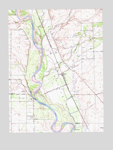
Vina, CA USGS Topographic Map
Click on map above to begin viewing in our Map Viewer.

This topographic map contains these locations and features:
Feature Name Type Latitude Longitude GNIS ID View Map
Acorn HollowValleyN39.9877°W122.0458°217962View Map
Blethen IslandIslandN39.9627°W122.0855°1670242View Map
Captain Jones RapidsRapidsN39.9235°W122.0828°1670243View Map
Champlin SloughStreamN39.9696°W122.0811°233654View Map
China SloughStreamN39.9252°W122.0814°221059View Map
CopelandPopulated PlaceN39.9554°W122.0636°1670244View Map
Copeland BarBarN39.9299°W122.0914°221532View Map
Corning Sewage DisposalLocaleN39.9165°W122.1047°1654216View Map
Deer CreekStreamN39.9263°W122.0817°1655075View Map
Delaney SloughStreamN39.9460°W122.0542°222245View Map
Doyle Pit Number 17MineN39.9814°W122.1206°2677342View Map
Dry CreekStreamN39.9893°W122.0453°222629View Map
Ensign (historical)Populated PlaceN39.9879°W122.0833°1670245View Map
Hazel BendBendN39.8838°W122.0447°1670210View Map
Hoag SloughStreamN39.8852°W122.0486°225370View Map
Island Number One (historical)IslandN39.8915°W122.0642°1670246View Map
Jewett CreekStreamN39.8777°W122.0692°226230View Map
Kopta SloughStreamN39.9113°W122.0953°226676View Map
Kopta Slough Boat-In CampLocaleN39.9157°W122.0983°1702509View Map
Laniger LakesLocaleN39.9727°W122.0386°226862View Map
McClure CreekStreamN39.9946°W122.1147°228305View Map
Merrill SchoolSchoolN39.8888°W122.0930°228529View Map
Merrills LandingPopulated PlaceN39.8782°W122.0397°1659116View Map
Moon SchoolSchoolN39.9149°W122.1225°229008View Map
Moone BarBarN39.8865°W122.0675°1670248View Map
North Main CanalCanalN39.9638°W122.0544°229739View Map
Plumas Rapids (historical)RapidsN39.9952°W122.0997°1670249View Map
Soto (historical)Populated PlaceN39.8768°W122.0208°1670259View Map
South Main CanalCanalN39.9518°W122.0389°235086View Map
Squaw HillPopulated PlaceN39.9079°W122.0930°1659849View Map
Squaw Hill Ferry (historical)CrossingN39.9090°W122.0917°1670250View Map
Tehama County Fire Department Station 16 VinaBuildingN39.9286°W122.0522°2622103View Map
Tehama County River ParkParkN39.9096°W122.0900°1702512View Map
Thomes CreekStreamN39.9904°W122.0961°255137View Map
Toomes CreekStreamN39.9643°W122.0817°236465View Map
VinaPopulated PlaceN39.9329°W122.0539°237087View Map
Vina Census Designated PlaceCensusN39.9342°W122.0517°2628796View Map
Vina Elementary SchoolSchoolN39.9351°W122.0539°1692763View Map
Vina Post OfficePost OfficeN39.9334°W122.0544°2760053View Map
Vina SloughGutN39.9354°W122.0800°1670251View Map
West North Main CanalCanalN39.9557°W122.0447°237504View Map
Woodson BridgeBridgeN39.9093°W122.0914°252063View Map
Woodson Bridge Natural PreserveReserveN39.9193°W122.0934°2741350View Map
Woodson Bridge State Recreation AreaParkN39.9174°W122.0914°238170View Map

Note: Coordinates in the location and feature list above are referenced to NAD83 datum.


Copyright (C) 2008-2025 Ryan Niemi / Sunset Dynamics ... All Rights Reserved