TopoQuest Logo
Do you find TopoQuest useful?
Help keep TopoQuest running and adding new maps/features by donating!
Bitcoin:  19c7KJd3qBynnjoSw5npx9KScwjBe4ifkT
Litecoin:  LXs6TkuXGGXo1vDsWCkWVdjQX94eUKd6ui
Home View Maps Find Maps Find Places Resources & Links


Vining, Minnesota Topographic Map

USGS Map Title: Vining, MN
USGS Map MRC: 46095C5
DRG (GeoTIFF) Download: o46095c5.tif


Neighboring USGS Topographic Map Quads:


  Walker Lake, MN  
46095D6
 

  Ottertail, MN  
46095D5
 

  Heinola, MN  
46095D4
 

  Battle Lake, MN  
46095C6
 

  Vining, MN  
46095C5
 

  Henning, MN  
46095C4
 

  Eagle Lake, MN  
46095B6
 

  Inspiration Peak, MN  
46095B5
 

  Parkers Prairie NW, MN  
46095B4


Map MRC Location:

N47°
W96°
N47°
W95°
H8 H7 H6 H5 H4 H3 H2 H1
G8 G7 G6 G5 G4 G3 G2 G1
F8 F7 F6 F5 F4 F3 F2 F1
E8 E7 E6 E5 E4 E3 E2 E1
D8 D7 D6 D5 D4 D3 D2 D1
C8 C7 C6 C5 C4 C3 C2 C1
B8 B7 B6 B5 B4 B3 B2 B1
A8 A7 A6 A5 A4 A3 A2 A1
N46°
W96°
N46°
W95°

Vining, MN USGS 1:24K Topographic Map Preview:
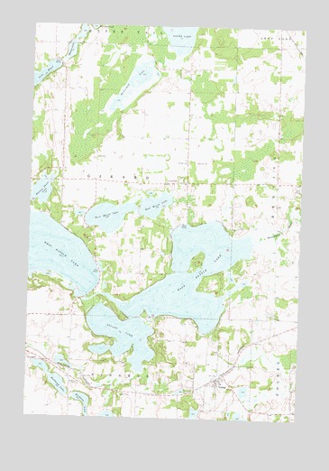
Vining, MN USGS Topographic Map
Click on map above to begin viewing in our Map Viewer.

This topographic map contains these locations and features:
Feature Name Type Latitude Longitude GNIS ID View Map
Beauty Shore LakeLakeN46.3203°W95.6227°639812View Map
Brandborg CreekStreamN46.3061°W95.5220°640434View Map
Bredeson LakeLakeN46.2549°W95.5985°640450View Map
Bullhead LakeLakeN46.2604°W95.6101°640636View Map
City of ViningCivilN46.2613°W95.5342°2397145View Map
Clitherall Wayside ParkParkN46.2683°W95.6197°2073148View Map
East Battle LakeLakeN46.2955°W95.5498°643046View Map
East Battle LakeReservoirN46.2866°W95.5987°1776255View Map
East Battle Lake DamDamN46.2866°W95.5987°1776254View Map
East Mason LakeLakeN46.3177°W95.5677°643094View Map
Girard CemeteryCemeteryN46.3319°W95.5523°644155View Map
Hanson LakeLakeN46.3669°W95.6080°644646View Map
Lake EthelLakeN46.3574°W95.6244°643423View Map
Nidaros Lutheran ChurchChurchN46.2589°W95.5375°2072726View Map
NirvanaPopulated PlaceN46.2817°W95.5814°2125215View Map
School Number 100 (historical)SchoolN46.3114°W95.5053°2125212View Map
School Number 152 (historical)SchoolN46.3325°W95.5536°2125211View Map
School Number 153 (historical)SchoolN46.2958°W95.5858°2125213View Map
School Number 174 (historical)SchoolN46.3328°W95.6103°2125210View Map
School Number 205 (historical)SchoolN46.3494°W95.5119°2125207View Map
Stuart LakeLakeN46.2762°W95.5815°652737View Map
Tamarack LakeLakeN46.3582°W95.5748°653007View Map
Township of GirardCivilN46.3256°W95.5941°664273View Map
ViningPopulated PlaceN46.2630°W95.5370°653669View Map
Vining (historical)LocaleN46.2639°W95.5361°2073076View Map
Vining Fire DepartmentBuildingN46.2627°W95.5367°2666542View Map
Vining Lutheran ChurchChurchN46.2631°W95.5367°2073074View Map
Vining Post OfficePost OfficeN46.2631°W95.5367°2073075View Map
West Mason LakeLakeN46.3140°W95.5893°653986View Map
Woodland ParkPopulated PlaceN46.3108°W95.5342°2125216View Map

Note: Coordinates in the location and feature list above are referenced to NAD83 datum.


Copyright (C) 2008-2024 Ryan Niemi / Sunset Dynamics ... All Rights Reserved