TopoQuest Logo
Do you find TopoQuest useful?
Help keep TopoQuest running and adding new maps/features by donating!
Bitcoin:  19c7KJd3qBynnjoSw5npx9KScwjBe4ifkT
Litecoin:  LXs6TkuXGGXo1vDsWCkWVdjQX94eUKd6ui
Home View Maps Find Maps Find Places Resources & Links


Viola, California Topographic Map

USGS Map Title: Viola, CA
USGS Map MRC: 40121E6
DRG (GeoTIFF) Download: o40121e6.tif


Neighboring USGS Topographic Map Quads:


  Miller Mountain, CA  
40121F7
 

  Jacks Backbone, CA  
40121F6
 

  Thousand Lakes Valley, CA  
40121F5
 

  Hagaman Gulch, CA  
40121E7
 

  Viola, CA  
40121E6
 

  Manzanita Lake, CA  
40121E5
 

  Manton, CA  
40121D7
 

  Grays Peak, CA  
40121D6
 

  Lassen Peak, CA  
40121D5


Map MRC Location:

N41°
W122°
N41°
W121°
H8 H7 H6 H5 H4 H3 H2 H1
G8 G7 G6 G5 G4 G3 G2 G1
F8 F7 F6 F5 F4 F3 F2 F1
E8 E7 E6 E5 E4 E3 E2 E1
D8 D7 D6 D5 D4 D3 D2 D1
C8 C7 C6 C5 C4 C3 C2 C1
B8 B7 B6 B5 B4 B3 B2 B1
A8 A7 A6 A5 A4 A3 A2 A1
N40°
W122°
N40°
W121°

Viola, CA USGS 1:24K Topographic Map Preview:
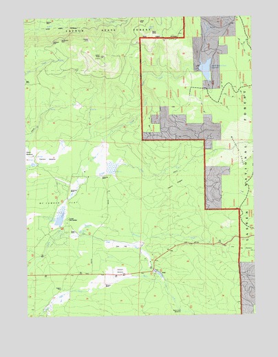
Viola, CA USGS Topographic Map
Click on map above to begin viewing in our Map Viewer.

This topographic map contains these locations and features:
Feature Name Type Latitude Longitude GNIS ID View Map
Armstrong RanchLocaleN40.5588°W121.7100°218378View Map
Bailey Creek MeadowsFlatN40.5015°W121.6658°218526View Map
Bateman PlacePopulated PlaceN40.6235°W121.7386°1661771View Map
Beal PlacePopulated PlaceN40.5977°W121.7497°1658011View Map
Bridges CreekStreamN40.5549°W121.7225°219828View Map
Buck ButteSummitN40.6185°W121.6808°1661779View Map
Bullhock CreekStreamN40.6193°W121.7128°233571View Map
Camp McCumberLocaleN40.5404°W121.7292°220473View Map
Castle RockPillarN40.6232°W121.6875°1661783View Map
Cherry ThicketWoodsN40.5546°W121.6694°1661786View Map
Cirque LakeLakeN40.6207°W121.6821°1661788View Map
Deer CreekStreamN40.5338°W121.7339°222172View Map
Deer FlatFlatN40.5293°W121.6986°222184View Map
Eastman PlacePopulated PlaceN40.5113°W121.7325°1658466View Map
Farnsworth RanchLocaleN40.5524°W121.7264°223405View Map
Hootman RanchLocaleN40.5132°W121.7078°225547View Map
Latour ButteSummitN40.6074°W121.7094°226928View Map
Manzanita CreekStreamN40.5338°W121.7244°234239View Map
Manzanita SpringSpringN40.5385°W121.7191°228053View Map
McCumber 97-094 DamDamN40.5377°W121.7328°1663650View Map
McCumber FlatFlatN40.5460°W121.7347°228336View Map
McCumber ReservoirReservoirN40.5406°W121.7329°228337View Map
Mountain Home SpringSpringN40.5353°W121.7222°229182View Map
Mushroom RockPillarN40.6157°W121.7308°1661835View Map
North Battle Creek 97-096 DamDamN40.6028°W121.6552°1663651View Map
North Battle Creek ReservoirReservoirN40.6028°W121.6514°229599View Map
Nunes RanchLocaleN40.5357°W121.7242°229811View Map
Palisade CliffCliffN40.6152°W121.7347°1661845View Map
Reservoir Public CampLocaleN40.6071°W121.6494°231503View Map
Rooster CombRidgeN40.6168°W121.7122°231867View Map
Scharsch MeadowsFlatN40.5185°W121.7000°1682392View Map
Scharsch RanchLocaleN40.5171°W121.7014°232644View Map
Thatchers MeadowsFlatN40.5671°W121.7347°236141View Map
ViolaPopulated PlaceN40.5179°W121.6778°1660106View Map
Viola Post Office (historical)Post OfficeN40.5179°W121.6778°1940048View Map

Note: Coordinates in the location and feature list above are referenced to NAD83 datum.


Copyright (C) 2008-2024 Ryan Niemi / Sunset Dynamics ... All Rights Reserved