TopoQuest Logo
Do you find TopoQuest useful?
Help keep TopoQuest running and adding new maps/features by donating!
Bitcoin:  19c7KJd3qBynnjoSw5npx9KScwjBe4ifkT
Litecoin:  LXs6TkuXGGXo1vDsWCkWVdjQX94eUKd6ui
Home View Maps Find Maps Find Places Resources & Links


Miller Mountain, California Topographic Map

USGS Map Title: Miller Mountain, CA
USGS Map MRC: 40121F7
DRG (GeoTIFF) Download: o40121f7.tif


Neighboring USGS Topographic Map Quads:


  Montgomery Creek, CA  
40121G8
 

  Hatchet Mountain Pass, CA  
40121G7
 

  Burney Mountain West, CA  
40121G6
 

  Whitmore, CA  
40121F8
 

  Miller Mountain, CA  
40121F7
 

  Jacks Backbone, CA  
40121F6
 

  Inwood, CA  
40121E8
 

  Hagaman Gulch, CA  
40121E7
 

  Viola, CA  
40121E6


Map MRC Location:

N41°
W122°
N41°
W121°
H8 H7 H6 H5 H4 H3 H2 H1
G8 G7 G6 G5 G4 G3 G2 G1
F8 F7 F6 F5 F4 F3 F2 F1
E8 E7 E6 E5 E4 E3 E2 E1
D8 D7 D6 D5 D4 D3 D2 D1
C8 C7 C6 C5 C4 C3 C2 C1
B8 B7 B6 B5 B4 B3 B2 B1
A8 A7 A6 A5 A4 A3 A2 A1
N40°
W122°
N40°
W121°

Miller Mountain, CA USGS 1:24K Topographic Map Preview:
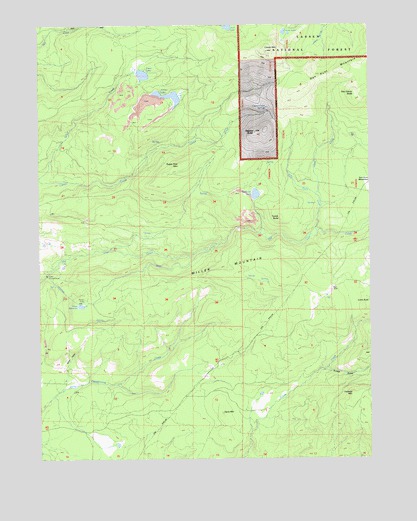
Miller Mountain, CA USGS Topographic Map
Click on map above to begin viewing in our Map Viewer.

This topographic map contains these locations and features:
Feature Name Type Latitude Longitude GNIS ID View Map
Arthur LakeLakeN40.7293°W121.8263°256333View Map
Blue LakeLakeN40.7495°W121.8041°257258View Map
Buckhorn LakeLakeN40.7011°W121.7941°257619View Map
Clover Creek SpringsSpringN40.7261°W121.7896°258475View Map
Clover MountainSummitN40.7421°W121.7900°258479View Map
Cutter ButteSummitN40.6690°W121.7514°1658364View Map
Dan Covey ButteSummitN40.7299°W121.7558°259033View Map
Dan Hunt MeadowsFlatN40.7032°W121.7547°221999View Map
Dan Hunt MountainSummitN40.7371°W121.7603°1658371View Map
Davis MountainSummitN40.6382°W121.8078°1658378View Map
Hunt CreekStreamN40.7010°W121.7714°261636View Map
Kilarc ReservoirReservoirN40.6696°W121.8630°262170View Map
Lookout MountainSummitN40.6418°W121.7578°1659009View Map
Miller MountainSummitN40.6796°W121.7842°1659131View Map
Miller ValleyValleyN40.6460°W121.8683°263641View Map
Mountain Grove School (historical)SchoolN40.6302°W121.8578°1682386View Map
Seven LakesLakeN40.7478°W121.7830°266010View Map
Silver LakeLakeN40.7356°W121.8365°266195View Map
Stacher ButteSummitN40.7182°W121.7947°267652View Map
Sugar Pine MountainSummitN40.7093°W121.8236°1659893View Map
Sunset GulchValleyN40.6499°W121.7686°267971View Map
Tucker ButteSummitN40.6943°W121.7850°1660037View Map
West Hunt CreekStreamN40.6896°W121.7725°268923View Map

Note: Coordinates in the location and feature list above are referenced to NAD83 datum.


Copyright (C) 2008-2024 Ryan Niemi / Sunset Dynamics ... All Rights Reserved