TopoQuest Logo
Do you find TopoQuest useful?
Help keep TopoQuest running and adding new maps/features by donating!
Bitcoin:  19c7KJd3qBynnjoSw5npx9KScwjBe4ifkT
Litecoin:  LXs6TkuXGGXo1vDsWCkWVdjQX94eUKd6ui
Home View Maps Find Maps Find Places Resources & Links


Boiling Springs North, North Carolina Topographic Map

USGS Map Title: Boiling Springs North, NC
USGS Map MRC: 35081C6
DRG (GeoTIFF) Download: o35081c6.tif


Neighboring USGS Topographic Map Quads:


  Sunshine, NC  
35081D7
 

  Polkville, NC  
35081D6
 

  Lawndale, NC  
35081D5
 

  Forest City, NC  
35081C7
 

  Boiling Springs North, NC  
35081C6
 

  Shelby, NC  
35081C5
 

  Chesnee, SC  
35081B7
 

  Boiling Springs South, NC  
35081B6
 

  Blacksburg North, SC  
35081B5


Map MRC Location:

N36°
W82°
N36°
W81°
H8 H7 H6 H5 H4 H3 H2 H1
G8 G7 G6 G5 G4 G3 G2 G1
F8 F7 F6 F5 F4 F3 F2 F1
E8 E7 E6 E5 E4 E3 E2 E1
D8 D7 D6 D5 D4 D3 D2 D1
C8 C7 C6 C5 C4 C3 C2 C1
B8 B7 B6 B5 B4 B3 B2 B1
A8 A7 A6 A5 A4 A3 A2 A1
N35°
W82°
N35°
W81°

Boiling Springs North, NC USGS 1:24K Topographic Map Preview:
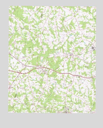
Boiling Springs North, NC USGS Topographic Map
Click on map above to begin viewing in our Map Viewer.

This topographic map contains these locations and features:
Feature Name Type Latitude Longitude GNIS ID View Map
29NC Airport (historical)AirportN35.3111°W81.6267°2679261View Map
Beam CemeteryCemeteryN35.3496°W81.7123°980682View Map
Beamans Mill (historical)LocaleN35.3335°W81.7001°1985935View Map
Boiling SpringsPopulated PlaceN35.2543°W81.6670°981688View Map
Boiling Springs City Volunteer Fire DepartmentBuildingN35.2503°W81.6654°2638363View Map
Boiling Springs Lifesaving and Rescue UnitBuildingN35.2712°W81.6667°2720541View Map
Boiling Springs Lifesaving and Rescue UnitBuildingN35.2536°W81.6673°2720349View Map
Boiling Springs Methodist ChurchChurchN35.2535°W81.6662°1007757View Map
Boiling Springs Post OfficePost OfficeN35.2507°W81.6670°2774244View Map
Boiling Springs Rural Volunteer Fire Department Station 1BuildingN35.2525°W81.6671°2639240View Map
Bowen BranchStreamN35.3687°W81.7101°981766View Map
Buck BranchStreamN35.3323°W81.7101°1023852View Map
Campfield Memorial ChurchChurchN35.3148°W81.7287°1019491View Map
Dobbins CemeteryCemeteryN35.3359°W81.7168°984234View Map
Dobbins ChurchChurchN35.3404°W81.7093°1019987View Map
Double Springs Baptist ChurchChurchN35.3396°W81.6379°984297View Map
Fairview School (historical)SchoolN35.3140°W81.7287°1008492View Map
Gantts Grove ChurchChurchN35.2785°W81.7287°1023417View Map
Glover CemeteryCemeteryN35.3521°W81.7472°985745View Map
Good (historical)Populated PlaceN35.2554°W81.7073°1001552View Map
Goodes Grove ChurchCemeteryN35.2559°W81.7433°2779048View Map
Goodes Grove ChurchChurchN35.2565°W81.7426°985800View Map
Grants Grove ChurchChurchN35.2785°W81.7287°985929View Map
Green (historical)Populated PlaceN35.2776°W81.7001°1001555View Map
Green Bethel ChurchChurchN35.2543°W81.6651°1004480View Map
LattimorePopulated PlaceN35.3182°W81.6607°988164View Map
Lattimore Baptist ChurchChurchN35.3162°W81.6665°1007758View Map
Lattimore CemeteryCemeteryN35.3143°W81.6670°2035396View Map
Lattimore Elementary SchoolSchoolN35.3196°W81.6593°1001569View Map
Lattimore Post OfficePost OfficeN35.3174°W81.6549°2774093View Map
Mayne CreekStreamN35.3165°W81.6945°1004476View Map
McBrayer CemeteryCemeteryN35.2840°W81.6690°1004479View Map
McKinney Mill (historical)LocaleN35.3487°W81.7273°1008503View Map
McKinney Mill BridgeBridgeN35.3487°W81.7268°1004475View Map
McSwain Mill (historical)LocaleN35.2618°W81.7220°2035514View Map
Mooneys Mill (historical)LocaleN35.3746°W81.6365°2036410View Map
MooresboroPopulated PlaceN35.2987°W81.6990°990208View Map
Mooresboro Post OfficePost OfficeN35.2987°W81.6990°2774212View Map
Number 7 Township Volunteer Fire DepartmentBuildingN35.3177°W81.6573°2638780View Map
Philadelphia ChurchChurchN35.3432°W81.7457°1004474View Map
Plainview ChurchChurchN35.2982°W81.7379°1004495View Map
Pleasant Ridge ChurchChurchN35.2873°W81.6582°1000776View Map
RehobethPopulated PlaceN35.3640°W81.6562°2036412View Map
Rehobeth CemeteryChurchN35.3648°W81.6551°2036413View Map
Rehobeth ChurchChurchN35.3660°W81.6557°993230View Map
Rehobeth School (historical)SchoolN35.3648°W81.6554°2036414View Map
Rock FordCrossingN35.3479°W81.6890°2036415View Map
Sandy Run Baptist ChurchChurchN35.2962°W81.6968°1004477View Map
Sandy Run CemeteryCemeteryN35.2960°W81.6962°2036417View Map
Sandy Run Township 7 (historical)CivilN35.3221°W81.6512°1026566View Map
Six PointsPopulated PlaceN35.2796°W81.7479°1023416View Map
SwainsvillePopulated PlaceN35.2940°W81.6515°995737View Map
Town of Boiling SpringsCivilN35.2521°W81.6636°2405296View Map
Town of LattimoreCivilN35.3154°W81.6602°2405990View Map
Town of MooresboroCivilN35.2992°W81.6986°2406187View Map
Trinity Baptist ChurchChurchN35.2598°W81.7157°996238View Map
WashburnPopulated PlaceN35.3310°W81.6293°996821View Map
West Cleveland Elementary SchoolSchoolN35.2537°W81.6634°1001592View Map
West Fork Sandy RunStreamN35.3162°W81.6948°1024402View Map
Youngs ChapelChurchN35.3051°W81.7045°1004478View Map
Youngs Store (historical)LocaleN35.2657°W81.6415°2036419View Map

Note: Coordinates in the location and feature list above are referenced to NAD83 datum.


Copyright (C) 2008-2024 Ryan Niemi / Sunset Dynamics ... All Rights Reserved