TopoQuest Logo
Do you find TopoQuest useful?
Help keep TopoQuest running and adding new maps/features by donating!
Bitcoin:  19c7KJd3qBynnjoSw5npx9KScwjBe4ifkT
Litecoin:  LXs6TkuXGGXo1vDsWCkWVdjQX94eUKd6ui
Home View Maps Find Maps Find Places Resources & Links


Polkville, North Carolina Topographic Map

USGS Map Title: Polkville, NC
USGS Map MRC: 35081D6
DRG (GeoTIFF) Download: o35081d6.tif


Neighboring USGS Topographic Map Quads:


  Dysartsville, NC  
35081E7
 

  Benn Knob, NC  
35081E6
 

  Casar, NC  
35081E5
 

  Sunshine, NC  
35081D7
 

  Polkville, NC  
35081D6
 

  Lawndale, NC  
35081D5
 

  Forest City, NC  
35081C7
 

  Boiling Springs North, NC  
35081C6
 

  Shelby, NC  
35081C5


Map MRC Location:

N36°
W82°
N36°
W81°
H8 H7 H6 H5 H4 H3 H2 H1
G8 G7 G6 G5 G4 G3 G2 G1
F8 F7 F6 F5 F4 F3 F2 F1
E8 E7 E6 E5 E4 E3 E2 E1
D8 D7 D6 D5 D4 D3 D2 D1
C8 C7 C6 C5 C4 C3 C2 C1
B8 B7 B6 B5 B4 B3 B2 B1
A8 A7 A6 A5 A4 A3 A2 A1
N35°
W82°
N35°
W81°

Polkville, NC USGS 1:24K Topographic Map Preview:
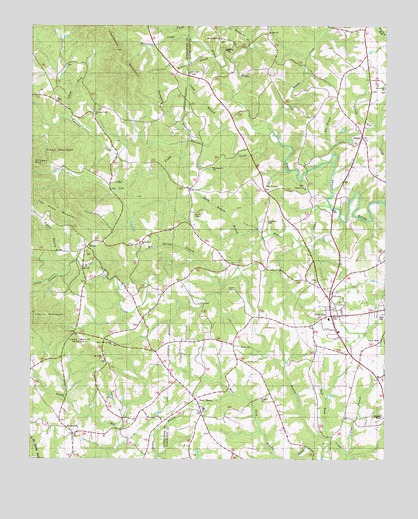
Polkville, NC USGS Topographic Map
Click on map above to begin viewing in our Map Viewer.

This topographic map contains these locations and features:
Feature Name Type Latitude Longitude GNIS ID View Map
Big BranchStreamN35.4632°W81.6429°981340View Map
Big Springs BranchStreamN35.4326°W81.6901°981456View Map
Big Springs ChurchChurchN35.4365°W81.7112°1019166View Map
Big Springs Church CemeteryCemeteryN35.4363°W81.7120°2779057View Map
Brooks ChapelChurchN35.4462°W81.6909°981970View Map
Brooks Chapel SchoolSchoolN35.4412°W81.7004°981971View Map
City of PolkvilleCivilN35.4163°W81.6440°2404545View Map
Cleveland Airport (historical)AirportN35.3879°W81.6251°1003968View Map
Cleveland County Emergency Medical Services Station 13BuildingN35.4142°W81.6425°2720421View Map
Cleveland Mills (historical)Populated PlaceN35.4993°W81.6451°1001536View Map
Clover Hill ChurchChurchN35.4826°W81.6251°1023913View Map
Crowder CemeteryCemeteryN35.3929°W81.6681°983802View Map
Cub CreekStreamN35.4671°W81.6945°983821View Map
Dark Hollow BranchStreamN35.4390°W81.6684°983959View Map
Daves Mill (historical)LocaleN35.4323°W81.7026°1008425View Map
DelightPopulated PlaceN35.4682°W81.6331°984124View Map
Duncans CreekStreamN35.4699°W81.6657°984427View Map
Duncans CreekPopulated PlaceN35.4501°W81.7165°1023425View Map
Duncans Creek Church CemeteryCemeteryN35.4744°W81.7276°2779058View Map
Duncans Creek Presbyterian ChurchChurchN35.4746°W81.7282°1020050View Map
East Fork Brushy CreekStreamN35.3815°W81.6445°984499View Map
Elliott CemeteryCemeteryN35.4248°W81.6779°984729View Map
Elliott ChurchChurchN35.4135°W81.6668°984730View Map
Five PointsPopulated PlaceN35.4523°W81.6665°1020263View Map
Flag BranchStreamN35.3765°W81.6384°985140View Map
Flint Hill (historical)LocaleN35.4587°W81.6743°1001550View Map
Green BranchStreamN35.4273°W81.7404°1024004View Map
Green CemeteryCemeteryN35.4076°W81.6759°986045View Map
Hinton CreekStreamN35.4479°W81.6443°986851View Map
HollisPopulated PlaceN35.4362°W81.7307°986937View Map
Hollis Methodist ChurchChurchN35.4343°W81.7290°1008442View Map
Hollis School (historical)SchoolN35.4348°W81.7301°1008443View Map
Holly Rush (historical)LocaleN35.4657°W81.6687°1001561View Map
HopewellPopulated PlaceN35.3829°W81.7345°1020831View Map
Hopewell CemeteryCemeteryN35.3822°W81.7344°2779054View Map
Hopewell ChurchChurchN35.3821°W81.7340°1008444View Map
Isham ForkStreamN35.4743°W81.7368°987413View Map
Jack Moore MountainSummitN35.4068°W81.7273°1020914View Map
Lattimore CemeteryCemeteryN35.4437°W81.6665°988165View Map
Lee ChapelChurchN35.4871°W81.6937°988296View Map
Lee Chapel CemeteryCemeteryN35.4862°W81.6936°2779059View Map
Lisenberry MountainSummitN35.4901°W81.7195°988522View Map
Long BranchStreamN35.4707°W81.6818°988905View Map
Morris Memorial ChurchChurchN35.4962°W81.6832°1003967View Map
Mount Harmony ChurchChurchN35.4593°W81.6859°1024169View Map
Mount Olivet ChurchChurchN35.4051°W81.7237°1021554View Map
Mount Olivet Church CemeteryCemeteryN35.4038°W81.7241°2779055View Map
Mount Zion ChurchChurchN35.4979°W81.6659°990649View Map
Mountain CreekStreamN35.4979°W81.6940°990686View Map
New HousePopulated PlaceN35.3929°W81.6918°991045View Map
No Business CreekStreamN35.4935°W81.6740°1024190View Map
Palmers Grove ChurchChurchN35.4540°W81.6532°1024740View Map
Palmers Grove School (historical)SchoolN35.4549°W81.6526°1024202View Map
Parker BranchStreamN35.4912°W81.6857°991857View Map
Piney MountainSummitN35.4640°W81.7454°1021973View Map
PolkvillePopulated PlaceN35.4176°W81.6429°992645View Map
Polkville Post OfficePost OfficeN35.4192°W81.6438°2774232View Map
Polkville SchoolSchoolN35.4157°W81.6415°1007760View Map
Polkville Township 8 (historical)CivilN35.4262°W81.6495°1026567View Map
Polkville Volunteer Fire DepartmentBuildingN35.4145°W81.6435°2638233View Map
Sandy Plains Baptist ChurchChurchN35.3898°W81.6895°1007759View Map
Taylor BranchStreamN35.4312°W81.7362°995883View Map
Thompson BranchStreamN35.4671°W81.6926°996045View Map
Tom Price MountainSummitN35.4468°W81.7373°1022962View Map
Township of Duncans CreekCivilN35.4577°W81.7357°1027159View Map
Wards CreekStreamN35.4724°W81.6662°1024390View Map
West Fork Brushy CreekStreamN35.3801°W81.6440°1024399View Map
White Oak Springs ChurchChurchN35.4087°W81.7207°1023201View Map
White Oak Springs Church CemeteryCemeteryN35.4082°W81.7201°2779056View Map

Note: Coordinates in the location and feature list above are referenced to NAD83 datum.


Copyright (C) 2008-2024 Ryan Niemi / Sunset Dynamics ... All Rights Reserved