TopoQuest Logo
Do you find TopoQuest useful?
Help keep TopoQuest running and adding new maps/features by donating!
Bitcoin:  19c7KJd3qBynnjoSw5npx9KScwjBe4ifkT
Litecoin:  LXs6TkuXGGXo1vDsWCkWVdjQX94eUKd6ui
Home View Maps Find Maps Find Places Resources & Links


Boise North, Idaho Topographic Map

USGS Map Title: Boise North, ID
USGS Map MRC: 43116F2
DRG (GeoTIFF) Download: o43116f2.tif


Neighboring USGS Topographic Map Quads:


  Pearl, ID  
43116G3
 

  Cartwright Canyon, ID  
43116G2
 

  Shafer Butte, ID  
43116G1
 

  Eagle, ID  
43116F3
 

  Boise North, ID  
43116F2
 

  Robie Creek, ID  
43116F1
 

  Cloverdale, ID  
43116E3
 

  Boise South, ID  
43116E2
 

  Lucky Peak, ID  
43116E1


Map MRC Location:

N44°
W117°
N44°
W116°
H8 H7 H6 H5 H4 H3 H2 H1
G8 G7 G6 G5 G4 G3 G2 G1
F8 F7 F6 F5 F4 F3 F2 F1
E8 E7 E6 E5 E4 E3 E2 E1
D8 D7 D6 D5 D4 D3 D2 D1
C8 C7 C6 C5 C4 C3 C2 C1
B8 B7 B6 B5 B4 B3 B2 B1
A8 A7 A6 A5 A4 A3 A2 A1
N43°
W117°
N43°
W116°

Boise North, ID USGS 1:24K Topographic Map Preview:
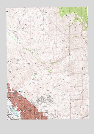
Boise North, ID USGS Topographic Map
Click on map above to begin viewing in our Map Viewer.

This topographic map contains these locations and features:
Feature Name Type Latitude Longitude GNIS ID View Map
Ada County Paramedics Medical Station 57BuildingN43.6322°W116.2093°2642807View Map
Bible CollegeSchoolN43.6371°W116.2198°377421View Map
Boise Cascade HeliportAirportN43.6532°W116.2060°400762View Map
Boise Cascade LakeLakeN43.6324°W116.2375°401212View Map
Boise City Fire Department Station 2BuildingN43.6518°W116.2017°2619255View Map
Boise City Fire Department Station 9BuildingN43.6484°W116.2453°2619261View Map
Boise Hills DivisionCivilN43.6496°W116.1395°1936681View Map
Boise Hills VillagePopulated PlaceN43.6324°W116.1898°396158View Map
Boise Police DepartmentBuildingN43.6448°W116.2437°2722483View Map
Boise Police DepartmentBuildingN43.6401°W116.2329°2722415View Map
Camelsback ParkParkN43.6379°W116.2010°399815View Map
CollisterPopulated PlaceN43.6582°W116.2482°399447View Map
Collister Elementary SchoolSchoolN43.6559°W116.2442°400612View Map
Collister Post OfficePost OfficeN43.6490°W116.2464°2779555View Map
Collister Shopping CenterLocaleN43.6499°W116.2468°395244View Map
Crane CreekStreamN43.6338°W116.2354°380029View Map
Crane Creek FlumeLocaleN43.6354°W116.2229°380030View Map
Crane GulchValleyN43.6438°W116.2046°380031View Map
Daniels CreekStreamN43.7004°W116.2140°380237View Map
Elm Grove ParkParkN43.6366°W116.2165°396459View Map
HighlandsPopulated PlaceN43.6460°W116.1937°396653View Map
Highlands Elementary SchoolSchoolN43.6502°W116.1948°400635View Map
Hillside Junior High SchoolSchoolN43.6564°W116.2316°383209View Map
Hulls GulchValleyN43.6391°W116.1957°399926View Map
Hulls Gulch Nature TrailTrailN43.6585°W116.1293°394366View Map
Idaho Transportation Department and Law EnforcementBuildingN43.6354°W116.2307°399155View Map
KIDOTowerN43.6296°W116.1815°400355View Map
Longfellow Elementary SchoolSchoolN43.6280°W116.1991°400650View Map
Lowell Elementary SchoolSchoolN43.6341°W116.2238°400651View Map
Madison Early Childhood CenterSchoolN43.6251°W116.2177°400652View Map
Marian Pritchett SchoolSchoolN43.6353°W116.2191°401266View Map
McCauley ParkParkN43.6268°W116.2087°386576View Map
Miller GulchValleyN43.6679°W116.2010°386972View Map
North Ada County Fire and Rescue Station 2BuildingN43.6269°W116.2459°2619264View Map
North Fork Daniels CreekStreamN43.6996°W116.1932°387679View Map
North Junior High SchoolSchoolN43.6259°W116.2040°387822View Map
Peaceful Cove AirportAirportN43.6705°W116.2114°2443831View Map
Polecat GulchValleyN43.6693°W116.2476°388702View Map
Saint Marys SchoolSchoolN43.6316°W116.2226°389840View Map
Shingle CreekStreamN43.7024°W116.1551°390324View Map
South Fork Daniels CreekStreamN43.6996°W116.1929°390918View Map
Stewart GulchValleyN43.6618°W116.2198°400116View Map
Sunset ParkParkN43.6416°W116.2301°399156View Map
Taft Elementary SchoolSchoolN43.6415°W116.2357°400690View Map
Terteling SpringsSpringN43.6766°W116.2087°393898View Map
Veterans Memorial State ParkParkN43.6377°W116.2365°399747View Map
Washington Elementary SchoolSchoolN43.6324°W116.2063°400699View Map
West StateLocaleN43.6399°W116.2337°399639View Map

Note: Coordinates in the location and feature list above are referenced to NAD83 datum.


Copyright (C) 2008-2025 Ryan Niemi / Sunset Dynamics ... All Rights Reserved