TopoQuest Logo
Do you find TopoQuest useful?
Help keep TopoQuest running and adding new maps/features by donating!
Bitcoin:  19c7KJd3qBynnjoSw5npx9KScwjBe4ifkT
Litecoin:  LXs6TkuXGGXo1vDsWCkWVdjQX94eUKd6ui
Home View Maps Find Maps Find Places Resources & Links


Lucky Peak, Idaho Topographic Map

USGS Map Title: Lucky Peak, ID
USGS Map MRC: 43116E1
DRG (GeoTIFF) Download: o43116e1.tif


Neighboring USGS Topographic Map Quads:


  Boise North, ID  
43116F2
 

  Robie Creek, ID  
43116F1
 

  Dunnigan Creek, ID  
43115F8
 

  Boise South, ID  
43116E2
 

  Lucky Peak, ID  
43116E1
 

  Arrowrock Dam, ID  
43115E8
 

  Owyhee, ID  
43116D2
 

  Indian Creek Reservoir, ID  
43116D1
 

  Mayfield, ID  
43115D8


Map MRC Location:

N44°
W117°
N44°
W116°
H8 H7 H6 H5 H4 H3 H2 H1
G8 G7 G6 G5 G4 G3 G2 G1
F8 F7 F6 F5 F4 F3 F2 F1
E8 E7 E6 E5 E4 E3 E2 E1
D8 D7 D6 D5 D4 D3 D2 D1
C8 C7 C6 C5 C4 C3 C2 C1
B8 B7 B6 B5 B4 B3 B2 B1
A8 A7 A6 A5 A4 A3 A2 A1
N43°
W117°
N43°
W116°

Lucky Peak, ID USGS 1:24K Topographic Map Preview:
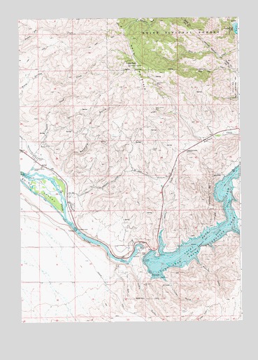
Lucky Peak, ID USGS Topographic Map
Click on map above to begin viewing in our Map Viewer.

This topographic map contains these locations and features:
Feature Name Type Latitude Longitude GNIS ID View Map
Adelmann MineMineN43.5977°W116.0471°376476View Map
BarberPopulated PlaceN43.5652°W116.1132°397406View Map
Barber DamDamN43.5604°W116.1218°397408View Map
Barber District Ranger StationLocaleN43.5610°W116.1084°394126View Map
Barclay Bay Picnic AreaParkN43.5193°W116.0515°376946View Map
Black Hornet MineMineN43.5868°W116.0476°377749View Map
Boise Diversion DamDamN43.5377°W116.0935°398877View Map
Charcoal CreekStreamN43.5382°W116.0059°379196View Map
Council Spring CreekStreamN43.5724°W116.1204°391278View Map
Discovery Picnic AreaParkN43.5254°W116.0646°380608View Map
Highland Valley SummitSummitN43.5704°W116.0312°383186View Map
Lucky PeakSummitN43.6052°W116.0612°386273View Map
Lucky Peak DamDamN43.5282°W116.0532°397882View Map
Lucky Peak State Recreation AreaParkN43.5302°W116.0223°396829View Map
Lydle GulchValleyN43.5243°W116.0626°386302View Map
Maynard GulchValleyN43.5627°W116.1007°386562View Map
Penitentiary CanalCanalN43.5616°W116.1054°388332View Map
Pipeline GulchValleyN43.5235°W116.0229°388562View Map
Queen MineMineN43.5710°W116.0498°388988View Map
Sandy Point BeachBeachN43.5307°W116.0582°398096View Map
Shaw MountainSummitN43.6052°W116.0612°397150View Map
Sheep CreekStreamN43.5379°W116.0443°390181View Map
Sheep Creek Access AreaLocaleN43.5449°W116.0429°401200View Map
Turner GulchValleyN43.5166°W116.0423°392463View Map

Note: Coordinates in the location and feature list above are referenced to NAD83 datum.


Copyright (C) 2008-2024 Ryan Niemi / Sunset Dynamics ... All Rights Reserved