TopoQuest Logo
Do you find TopoQuest useful?
Help keep TopoQuest running and adding new maps/features by donating!
Bitcoin:  19c7KJd3qBynnjoSw5npx9KScwjBe4ifkT
Litecoin:  LXs6TkuXGGXo1vDsWCkWVdjQX94eUKd6ui
Home View Maps Find Maps Find Places Resources & Links


Walker, Arkansas Topographic Map

USGS Map Title: Walker, AR
USGS Map MRC: 35091A6
DRG (GeoTIFF) Download: o35091a6.tif


Neighboring USGS Topographic Map Quads:


  Garner, AR  
35091B7
 

  Kensett, AR  
35091B6
 

  West Point, AR  
35091B5
 

  McRae, AR  
35091A7
 

  Walker, AR  
35091A6
 

  Jasmine, AR  
35091A5
 

  Wattensaw, AR  
34091H7
 

  Hickory Plains, AR  
34091H6
 

  Des Arc West, AR  
34091H5


Map MRC Location:

N36°
W92°
N36°
W91°
H8 H7 H6 H5 H4 H3 H2 H1
G8 G7 G6 G5 G4 G3 G2 G1
F8 F7 F6 F5 F4 F3 F2 F1
E8 E7 E6 E5 E4 E3 E2 E1
D8 D7 D6 D5 D4 D3 D2 D1
C8 C7 C6 C5 C4 C3 C2 C1
B8 B7 B6 B5 B4 B3 B2 B1
A8 A7 A6 A5 A4 A3 A2 A1
N35°
W92°
N35°
W91°

Walker, AR USGS 1:24K Topographic Map Preview:
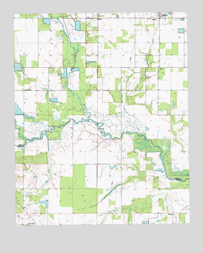
Walker, AR USGS Topographic Map
Click on map above to begin viewing in our Map Viewer.

This topographic map contains these locations and features:
Feature Name Type Latitude Longitude GNIS ID View Map
Bull CreekStreamN35.0509°W91.7407°47168View Map
Cane CreekStreamN35.0587°W91.7218°47378View Map
Carsons SloughStreamN35.1195°W91.7168°47487View Map
Cheek LakeLakeN35.0684°W91.7487°75670View Map
Cypress BayouStreamN35.0623°W91.6965°76735View Map
Defiance (historical)Populated PlaceN35.1081°W91.7326°65056View Map
DogwoodPopulated PlaceN35.0923°W91.6554°65057View Map
Dogwood CemeteryCemeteryN35.0892°W91.6590°48557View Map
Dogwood CemeteryCemeteryN35.0873°W91.6562°65058View Map
Dogwood CreekStreamN35.0529°W91.6593°48560View Map
Dogwood United Methodist ChurchChurchN35.0873°W91.6560°76809View Map
Egbert (historical)Populated PlaceN35.0904°W91.6465°65061View Map
Glade CreekStreamN35.0984°W91.7068°49430View Map
GriffithvillePopulated PlaceN35.1237°W91.6451°57852View Map
Griffithville Elementary SchoolSchoolN35.1209°W91.6476°65074View Map
Griffithville High SchoolSchoolN35.1206°W91.6482°65075View Map
Hickory Plains SchoolSchoolN35.0001°W91.7374°50073View Map
Horsehead CreekStreamN35.1029°W91.7040°50330View Map
Jenkins LakeReservoirN35.0751°W91.6835°77275View Map
Jenkins Lake DamDamN35.0751°W91.6835°79763View Map
Lindermans LakeLakeN35.0326°W91.6424°77280View Map
Little LakeLakeN35.0523°W91.6571°77281View Map
Mooresville (historical)Populated PlaceN35.0079°W91.6949°64723View Map
Pleasant Ridge ChurchChurchN35.0001°W91.7415°53596View Map
Powell CreekStreamN35.0184°W91.6412°53744View Map
Southeast White County Volunteer Fire StationBuildingN35.1234°W91.6444°2117150View Map
Stewarts ReservoirReservoirN35.0640°W91.7376°77312View Map
Town of GriffithvilleCivilN35.1245°W91.6457°2406619View Map
Township of WalkerCivilN35.1127°W91.6919°69854View Map
Vinity CornerPopulated PlaceN35.0798°W91.7432°57225View Map
WalkerPopulated PlaceN35.1220°W91.6896°57226View Map
Walker CemeteryCemeteryN35.1223°W91.6949°55953View Map
Webb BranchStreamN35.0618°W91.6996°60061View Map
White CreekStreamN35.0262°W91.6337°56255View Map

Note: Coordinates in the location and feature list above are referenced to NAD83 datum.


Copyright (C) 2008-2024 Ryan Niemi / Sunset Dynamics ... All Rights Reserved