TopoQuest Logo
Do you find TopoQuest useful?
Help keep TopoQuest running and adding new maps/features by donating!
Bitcoin:  19c7KJd3qBynnjoSw5npx9KScwjBe4ifkT
Litecoin:  LXs6TkuXGGXo1vDsWCkWVdjQX94eUKd6ui
Home View Maps Find Maps Find Places Resources & Links


Jasmine, Arkansas Topographic Map

USGS Map Title: Jasmine, AR
USGS Map MRC: 35091A5
DRG (GeoTIFF) Download: o35091a5.tif


Neighboring USGS Topographic Map Quads:


  Kensett, AR  
35091B6
 

  West Point, AR  
35091B5
 

  Georgetown, AR  
35091B4
 

  Walker, AR  
35091A6
 

  Jasmine, AR  
35091A5
 

  Gregory SW, AR  
35091A4
 

  Hickory Plains, AR  
34091H6
 

  Des Arc West, AR  
34091H5
 

  Des Arc East, AR  
34091H4


Map MRC Location:

N36°
W92°
N36°
W91°
H8 H7 H6 H5 H4 H3 H2 H1
G8 G7 G6 G5 G4 G3 G2 G1
F8 F7 F6 F5 F4 F3 F2 F1
E8 E7 E6 E5 E4 E3 E2 E1
D8 D7 D6 D5 D4 D3 D2 D1
C8 C7 C6 C5 C4 C3 C2 C1
B8 B7 B6 B5 B4 B3 B2 B1
A8 A7 A6 A5 A4 A3 A2 A1
N35°
W92°
N35°
W91°

Jasmine, AR USGS 1:24K Topographic Map Preview:
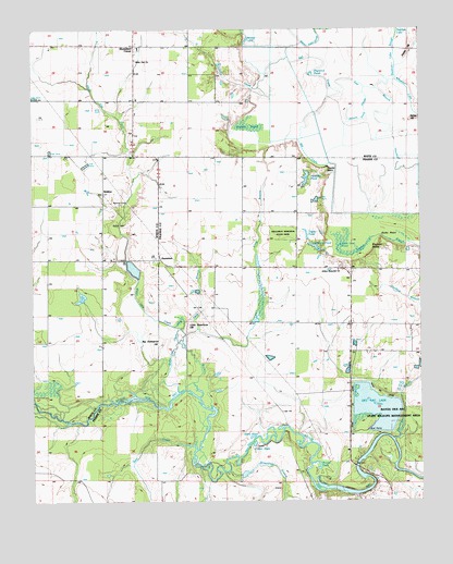
Jasmine, AR USGS Topographic Map
Click on map above to begin viewing in our Map Viewer.

This topographic map contains these locations and features:
Feature Name Type Latitude Longitude GNIS ID View Map
Bear CreekStreamN35.0140°W91.5726°46212View Map
Beaver Pond SloughStreamN35.1176°W91.5424°46275View Map
BelcherPopulated PlaceN35.0818°W91.6021°56924View Map
Belcher CemeteryCemeteryN35.0790°W91.5968°46340View Map
Bevel BrakeSwampN35.0948°W91.5568°46496View Map
Big Greenbrier HillSummitN35.0426°W91.5849°46557View Map
Big Gum Pond (historical)SwampN35.0787°W91.5065°83351View Map
Blind BasinLakeN35.0172°W91.5547°74678View Map
Blue Hole (historical)LakeN35.1026°W91.5143°83352View Map
Brownings BranchStreamN35.0079°W91.5618°47016View Map
Browns Pond (historical)LakeN35.1004°W91.5224°83353View Map
Browns Pond SloughStreamN35.1093°W91.5179°47025View Map
Clemens Brake (historical)SwampN35.0968°W91.5182°83354View Map
Coitier BasinLakeN35.0154°W91.5539°74753View Map
Crooked CreekStreamN35.0956°W91.5393°48172View Map
Crow Lake (historical)LakeN35.0948°W91.5043°83355View Map
Darst BranchStreamN35.0456°W91.5721°48363View Map
Diamond PondLakeN35.1135°W91.5349°74790View Map
Dicks PointCliffN35.0695°W91.5126°48510View Map
Eagle BrakeSwampN35.1062°W91.5435°48729View Map
East Branch Raft CreekStreamN35.1087°W91.5260°48753View Map
Enarc (historical)Populated PlaceN35.0293°W91.5510°64720View Map
Fowler PointCliffN35.0879°W91.5290°49210View Map
Friendship ChurchChurchN35.0623°W91.5560°49263View Map
Goose BasinLakeN35.0045°W91.5329°74847View Map
Griffin CemeteryCemeteryN35.0734°W91.5948°49675View Map
Gum Brake (historical)SwampN35.0937°W91.5249°83357View Map
Hacks HillSummitN35.1184°W91.5040°57862View Map
Hicksville (historical)Populated PlaceN35.0973°W91.6182°65080View Map
Holloway Memorial State ParkParkN35.0709°W91.5446°83366View Map
Holloway PondReservoirN35.0673°W91.5339°74898View Map
Holloway School (historical)SchoolN35.0620°W91.5574°64722View Map
Hunterton (historical)Populated PlaceN35.0209°W91.5440°60011View Map
Jarvers LakeLakeN35.1225°W91.5556°74925View Map
JasminePopulated PlaceN35.0643°W91.5837°77369View Map
Judson Memorial ChurchChurchN35.0612°W91.5265°50755View Map
KABK-FM (Augusta)TowerN35.0037°W91.5504°85361View Map
Keathley PondLakeN35.0857°W91.5368°74935View Map
Keathley Pond DamDamN35.0870°W91.5360°80319View Map
Lake Des ArcReservoirN35.0246°W91.5146°80321View Map
Lake Des Arc DamDamN35.0218°W91.5085°80320View Map
Little Greenbrier HillSummitN35.0470°W91.5749°58075View Map
Little Gum PondLakeN35.0679°W91.5258°74961View Map
Long BranchStreamN35.0276°W91.5712°51410View Map
McGhee Lake (historical)LakeN35.0943°W91.5385°83359View Map
Northside Volunteer Fire DepartmentBuildingN35.0620°W91.5397°2116881View Map
Overflow BranchStreamN35.0165°W91.5090°53101View Map
Rafes HillSummitN35.1012°W91.5021°58453View Map
Rayburn BrakeSwampN35.0655°W91.5220°53923View Map
Redman Lake SloughStreamN35.1093°W91.5140°53964View Map
Round BasinLakeN35.0095°W91.5326°75105View Map
Round Brake (historical)SwampN35.0970°W91.5312°83360View Map
Showalters CornerPopulated PlaceN35.1206°W91.5918°83365View Map
Stineville (historical)Populated PlaceN35.0540°W91.5743°60052View Map
Taylor PondReservoirN35.0707°W91.5367°75167View Map
Township of Des ArcCivilN35.0513°W91.5209°69004View Map
Township of DogwoodCivilN35.0968°W91.6091°69828View Map
Tripp StripAirportN35.1208°W91.6120°2650759View Map
Watkins BrakeSwampN35.0995°W91.5550°56098View Map
Welcome Home ChurchChurchN35.0620°W91.5257°56140View Map
Wheaton LakeLakeN35.1079°W91.5035°75211View Map
White Oak ChurchChurchN35.1170°W91.5915°56266View Map
White Oak CreekStreamN35.0293°W91.5779°56280View Map
White Oak School (historical)SchoolN35.1065°W91.5924°65127View Map
Willard (historical)Populated PlaceN35.0476°W91.5685°60068View Map

Note: Coordinates in the location and feature list above are referenced to NAD83 datum.


Copyright (C) 2008-2025 Ryan Niemi / Sunset Dynamics ... All Rights Reserved