TopoQuest Logo
Do you find TopoQuest useful?
Help keep TopoQuest running and adding new maps/features by donating!
Bitcoin:  19c7KJd3qBynnjoSw5npx9KScwjBe4ifkT
Litecoin:  LXs6TkuXGGXo1vDsWCkWVdjQX94eUKd6ui
Home View Maps Find Maps Find Places Resources & Links


Waller NW, Texas Topographic Map

USGS Map Title: Waller NW, TX
USGS Map MRC: 30095B8
DRG (GeoTIFF) Download: o30095b8.tif


Neighboring USGS Topographic Map Quads:


  Courtney, TX  
30096C1
 

  Stoneham, TX  
30095C8
 

  Plantersville, TX  
30095C7
 

  Howth, TX  
30096B1
 

  Waller NW, TX  
30095B8
 

  Magnolia West, TX  
30095B7
 

  Hempstead, TX  
30096A1
 

  Waller, TX  
30095A8
 

  Hockley, TX  
30095A7


Map MRC Location:

N31°
W96°
N31°
W95°
H8 H7 H6 H5 H4 H3 H2 H1
G8 G7 G6 G5 G4 G3 G2 G1
F8 F7 F6 F5 F4 F3 F2 F1
E8 E7 E6 E5 E4 E3 E2 E1
D8 D7 D6 D5 D4 D3 D2 D1
C8 C7 C6 C5 C4 C3 C2 C1
B8 B7 B6 B5 B4 B3 B2 B1
A8 A7 A6 A5 A4 A3 A2 A1
N30°
W96°
N30°
W95°

Waller NW, TX USGS 1:24K Topographic Map Preview:
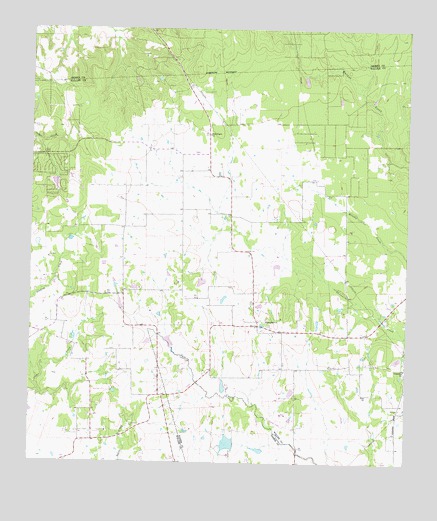
Waller NW, TX USGS Topographic Map
Click on map above to begin viewing in our Map Viewer.

This topographic map contains these locations and features:
Feature Name Type Latitude Longitude GNIS ID View Map
Fields StorePopulated PlaceN30.1447°W95.9561°2034785View Map
Friendship ChurchChurchN30.1524°W95.8755°1336227View Map
Good Hope ChurchChurchN30.1660°W95.9211°1336689View Map
Japhet LakeReservoirN30.1309°W95.9340°1860946View Map
Japhet Lake DamDamN30.1302°W95.9319°1860945View Map
Ken Ada Ranch Airport (historical)AirportN30.1380°W95.9166°1387705View Map
Kirby Chapel CemeteryCemeteryN30.1341°W95.9841°1339155View Map
Lynch LakeReservoirN30.1292°W95.9243°1860948View Map
Lynch Lake DamDamN30.1285°W95.9219°1860947View Map
Reids Prairie ChurchChurchN30.2197°W95.9397°1345024View Map
Rosenau CemeteryCemeteryN30.2216°W95.9975°1345586View Map
Simaron Ranch Airport (historical)AirportN30.1483°W95.9669°1387707View Map
Tri County Fire Department Station 2BuildingN30.1625°W95.8938°2552460View Map
Waller County Constable's Office Precinct 2BuildingN30.1624°W95.9160°2739408View Map

Note: Coordinates in the location and feature list above are referenced to NAD83 datum.


Copyright (C) 2008-2025 Ryan Niemi / Sunset Dynamics ... All Rights Reserved