TopoQuest Logo
Do you find TopoQuest useful?
Help keep TopoQuest running and adding new maps/features by donating!
Bitcoin:  19c7KJd3qBynnjoSw5npx9KScwjBe4ifkT
Litecoin:  LXs6TkuXGGXo1vDsWCkWVdjQX94eUKd6ui
Home View Maps Find Maps Find Places Resources & Links


Walnut, Mississippi Topographic Map

USGS Map Title: Walnut, MS
USGS Map MRC: 34088H8
DRG (GeoTIFF) Download: o34088h8.tif


Neighboring USGS Topographic Map Quads:


  Saulsbury, TN  
35089A1
 

  Middleton, TN  
35088A8
 

  Pocahontas, TN  
35088A7
 

  Camp Hill, MS  
34089H1
 

  Walnut, MS  
34088H8
 

  Chalybeate, MS  
34088H7
 

  Whitten Town, MS  
34089G1
 

  Falkner, MS  
34088G8
 

  Peoples, MS  
34088G7


Map MRC Location:

N35°
W89°
N35°
W88°
H8 H7 H6 H5 H4 H3 H2 H1
G8 G7 G6 G5 G4 G3 G2 G1
F8 F7 F6 F5 F4 F3 F2 F1
E8 E7 E6 E5 E4 E3 E2 E1
D8 D7 D6 D5 D4 D3 D2 D1
C8 C7 C6 C5 C4 C3 C2 C1
B8 B7 B6 B5 B4 B3 B2 B1
A8 A7 A6 A5 A4 A3 A2 A1
N34°
W89°
N34°
W88°

Walnut, MS USGS 1:24K Topographic Map Preview:
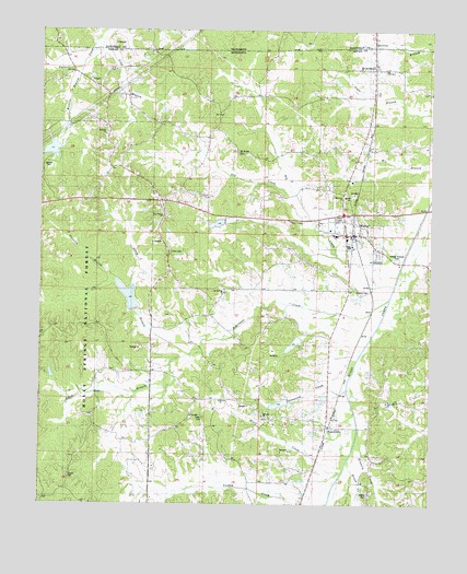
Walnut, MS USGS Topographic Map
Click on map above to begin viewing in our Map Viewer.

This topographic map contains these locations and features:
Feature Name Type Latitude Longitude GNIS ID View Map
Anvil (historical)LocaleN34.9223°W88.9820°704647View Map
Bald Hill SchoolSchoolN34.9020°W88.9451°692444View Map
Bald Hill School (historical)SchoolN34.9023°W88.9462°704648View Map
Ball Hill ChurchChurchN34.8981°W88.9287°704649View Map
Big CreekStreamN34.9331°W88.8862°692594View Map
Bluff CreekStreamN34.8840°W88.9023°692649View Map
BrownfieldPopulated PlaceN34.9901°W88.8926°692728View Map
Brownfield School (historical)SchoolN34.9898°W88.8889°706025View Map
Brownfield United Methodist ChurchChurchN34.9898°W88.8895°706026View Map
Brush CreekStreamN34.8862°W88.9023°692732View Map
Chism (historical)LocaleN34.9098°W88.9709°704655View Map
Christ TempleChurchN34.9495°W88.9201°704656View Map
Coker CemeteryCemeteryN34.8979°W88.9476°704657View Map
Drewery CreekStreamN34.8945°W88.8978°704660View Map
Dry CreekStreamN34.9579°W88.9198°693118View Map
Enon CemeteryCemeteryN34.9414°W88.9583°704661View Map
Gossett CemeteryCemeteryN34.9645°W88.9978°704662View Map
Haley (historical)LocaleN34.9279°W88.9434°683510View Map
Harmony CemeteryCemeteryN34.9570°W88.9028°704665View Map
Harmony ChurchChurchN34.9562°W88.9028°704666View Map
Holiness ChurchChurchN34.9023°W88.9423°704669View Map
Hopkins CemeteryCemeteryN34.9316°W88.8991°704670View Map
Hopkinsville (historical)LocaleN34.9320°W88.8942°706043View Map
Hurricane CreekStreamN34.9293°W88.8878°693567View Map
Liberty CemeteryCemeteryN34.8823°W88.9909°693717View Map
Liberty School (historical)SchoolN34.8831°W88.9903°706045View Map
Mount Hebron CemeteryCemeteryN34.9306°W88.9406°704677View Map
Mount Hebron ChurchChurchN34.9309°W88.9406°694058View Map
Mount MoriahPopulated PlaceN34.9715°W88.9403°706049View Map
Mount Moriah CemeteryCemeteryN34.9682°W88.9371°694062View Map
Mount Moriah School (historical)SchoolN34.9676°W88.9353°706050View Map
Muddy LakeReservoirN34.9300°W88.9718°711505View Map
New Salem CemeteryCemeteryN34.9512°W88.9601°704684View Map
New Salem ChurchChurchN34.9512°W88.9609°694188View Map
North Branch Hurricane CreekStreamN34.9148°W88.9520°694205View Map
Oak Grove LakeLakeN34.9091°W88.9963°705595View Map
Oakland CemeteryCemeteryN34.9720°W88.9792°704686View Map
Oakland ChurchChurchN34.9687°W88.9765°694242View Map
Oakland SchoolSchoolN34.9729°W88.9798°694243View Map
Pressley BranchStreamN34.9295°W88.9717°694471View Map
Rock Hill ChurchChurchN34.9020°W88.8887°704690View Map
Sand Hill School (historical)SchoolN34.9409°W88.9595°706071View Map
Smyrna CemeteryCemeteryN34.8793°W88.8939°694831View Map
South Branch Hurricane CreekStreamN34.9148°W88.9517°694840View Map
Spicewood CreekStreamN34.9054°W88.9009°694853View Map
Supervisor District 1CivilN34.9320°W88.9205°712095View Map
Three Forks Volunteer Fire DepartmentBuildingN34.9639°W88.9783°2665957View Map
TiplersvillePopulated PlaceN34.8956°W88.9076°694982View Map
Tiplersville Post OfficePost OfficeN34.8952°W88.9075°2766901View Map
Tipplersville Baptist ChurchChurchN34.8951°W88.9089°706076View Map
Tipplersville CemeteryCemeteryN34.8762°W88.9112°704699View Map
Tipplersville Church of ChristChurchN34.8959°W88.9114°706077View Map
Town of WalnutCivilN34.9497°W88.9237°2406825View Map
WalnutPopulated PlaceN34.9462°W88.8998°695090View Map
Walnut Baptist ChurchChurchN34.9465°W88.9023°704703View Map
Walnut Elementary SchoolSchoolN34.9462°W88.9064°706079View Map
Walnut Fire and RescueBuildingN34.9404°W88.9012°2665657View Map
Walnut High SchoolSchoolN34.9459°W88.9056°706080View Map
Walnut Methodist ChurchChurchN34.9462°W88.8981°706081View Map
Walnut Police DepartmentBuildingN34.9461°W88.9007°2754065View Map
Walnut Post OfficePost OfficeN34.9461°W88.9015°2760197View Map
Watkins BranchStreamN34.9901°W88.9881°695105View Map

Note: Coordinates in the location and feature list above are referenced to NAD83 datum.


Copyright (C) 2008-2024 Ryan Niemi / Sunset Dynamics ... All Rights Reserved