TopoQuest Logo
Do you find TopoQuest useful?
Help keep TopoQuest running and adding new maps/features by donating!
Bitcoin:  19c7KJd3qBynnjoSw5npx9KScwjBe4ifkT
Litecoin:  LXs6TkuXGGXo1vDsWCkWVdjQX94eUKd6ui
Home View Maps Find Maps Find Places Resources & Links


Falkner, Mississippi Topographic Map

USGS Map Title: Falkner, MS
USGS Map MRC: 34088G8
DRG (GeoTIFF) Download: o34088g8.tif


Neighboring USGS Topographic Map Quads:


  Camp Hill, MS  
34089H1
 

  Walnut, MS  
34088H8
 

  Chalybeate, MS  
34088H7
 

  Whitten Town, MS  
34089G1
 

  Falkner, MS  
34088G8
 

  Peoples, MS  
34088G7
 

  Blue Mountain, MS  
34089F1
 

  Ripley, MS  
34088F8
 

  Dumas, MS  
34088F7


Map MRC Location:

N35°
W89°
N35°
W88°
H8 H7 H6 H5 H4 H3 H2 H1
G8 G7 G6 G5 G4 G3 G2 G1
F8 F7 F6 F5 F4 F3 F2 F1
E8 E7 E6 E5 E4 E3 E2 E1
D8 D7 D6 D5 D4 D3 D2 D1
C8 C7 C6 C5 C4 C3 C2 C1
B8 B7 B6 B5 B4 B3 B2 B1
A8 A7 A6 A5 A4 A3 A2 A1
N34°
W89°
N34°
W88°

Falkner, MS USGS 1:24K Topographic Map Preview:
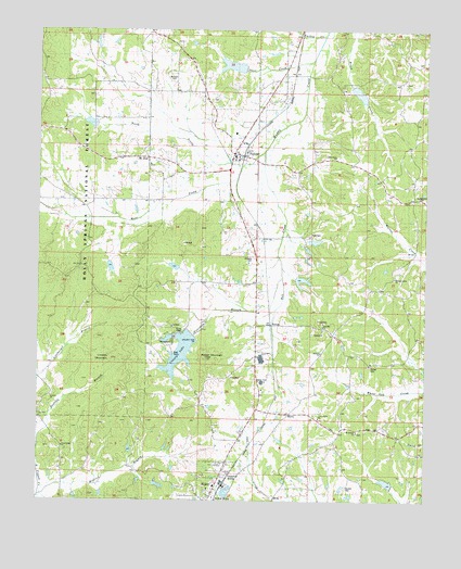
Falkner, MS USGS Topographic Map
Click on map above to begin viewing in our Map Viewer.

This topographic map contains these locations and features:
Feature Name Type Latitude Longitude GNIS ID View Map
Antioch CemeteryCemeteryN34.7784°W88.9951°704646View Map
Antioch ChurchChurchN34.7773°W88.9956°692409View Map
Antioch School (historical)SchoolN34.7790°W88.9956°706020View Map
B D Cox Pond DamDamN34.8734°W88.9801°695725View Map
Bell CreekStreamN34.8504°W88.9198°692532View Map
Beream ChurchChurchN34.7895°W88.9081°692540View Map
Bethlehem ChurchChurchN34.8415°W88.9045°704650View Map
Bowling BranchStreamN34.7645°W88.9995°692678View Map
Campbell SidingLocaleN34.7568°W88.9378°692820View Map
Centre High SchoolSchoolN34.7548°W88.8926°711567View Map
Cliff SidingLocaleN34.7734°W88.9245°692936View Map
Community ChurchChurchN34.7645°W88.9917°704658View Map
FalknerPopulated PlaceN34.8420°W88.9342°693198View Map
Falkner Baptist ChurchChurchN34.8426°W88.9334°706038View Map
Falkner Elementary SchoolSchoolN34.8406°W88.9370°706039View Map
Falkner High SchoolSchoolN34.8415°W88.9370°706040View Map
Falkner Methodist ChurchChurchN34.8406°W88.9359°706041View Map
Falkner Post OfficePost OfficeN34.8449°W88.9350°2760199View Map
Falkner Presbyterian ChurchChurchN34.8406°W88.9384°706042View Map
Falkner Volunteer Fire DepartmentBuildingN34.8412°W88.9329°2665955View Map
Fourmile BranchStreamN34.8093°W88.9209°693255View Map
Haleyondale (historical)LocaleN34.8668°W88.9987°704664View Map
Howell SidingLocaleN34.7523°W88.9412°693548View Map
Johnson CemeteryCemeteryN34.8148°W88.9312°704671View Map
Lindsey MountainSummitN34.7879°W88.9756°693727View Map
Linebarger BranchStreamN34.7818°W88.9995°693733View Map
McCowan CemeteryCemeteryN34.8629°W88.9576°704676View Map
Medlock BranchStreamN34.7529°W88.9987°693940View Map
Mount Moriah CemeteryCemeteryN34.7681°W88.8998°704678View Map
Mount Moriah ChurchChurchN34.7682°W88.8962°694067View Map
Mount ZionPopulated PlaceN34.8409°W88.9651°704680View Map
Mount Zion CemeteryCemeteryN34.8390°W88.9648°704681View Map
Mount Zion ChurchChurchN34.8395°W88.9642°694121View Map
Muddy (historical)LocaleN34.8148°W88.9220°704682View Map
Muddy Creek Number 36 DamDamN34.8334°W88.9084°695714View Map
Muddy Creek Structure 2 DamDamN34.8118°W88.9534°695705View Map
Muddy Creek Watershed Structure 1 DamDamN34.7934°W88.9484°695697View Map
Muddy Creek Watershed Structure 10A DamDamN34.8201°W88.9034°695709View Map
Muddy Creek Watershed Structure 23 DamDamN34.8101°W88.9167°695704View Map
Muddy Creek Watershed Structure 26 DamDamN34.8601°W88.8967°695722View Map
Muddy Creek Watershed Structure 5 DamDamN34.8501°W88.9817°695719View Map
Muddy Creek Watershed Structure 9 DamDamN34.8668°W88.9384°695723View Map
MurryLocaleN34.7732°W88.9190°704683View Map
Nance CemeteryCemeteryN34.7859°W88.8923°694144View Map
North Prong Muddy CreekStreamN34.8398°W88.9320°694211View Map
NortonLocaleN34.7968°W88.9251°704685View Map
Oak Hill SchoolSchoolN34.7732°W88.9098°694237View Map
Old Caroline Church (historical)ChurchN34.7690°W88.8939°706052View Map
Old Mount Zion CemeteryCemeteryN34.8568°W88.9428°694264View Map
Pine Hill CemeteryCemeteryN34.7954°W88.9078°704687View Map
Pine Hill ChurchChurchN34.7965°W88.9078°694386View Map
Pisgah CemeteryCemeteryN34.8298°W88.8801°704688View Map
Polk CemeteryCemeteryN34.8209°W88.9126°704689View Map
Rucker CemeteryCemeteryN34.7537°W88.9001°694627View Map
Ruckersville (historical)LocaleN34.8306°W88.8789°706070View Map
Ruckerville CemeteryCemeteryN34.8304°W88.8773°704691View Map
Ruckerville ChurchChurchN34.8309°W88.8778°694628View Map
Ruckerville SchoolSchoolN34.8412°W88.9031°694629View Map
Short CreekStreamN34.8665°W88.9117°694779View Map
Supervisor District 2CivilN34.7988°W88.9836°712096View Map
T Caffey Robertson Pond DamDamN34.8484°W88.9817°690448View Map
Tippah CountyCivilN34.7684°W88.9089°695790View Map
Tippah County LakeReservoirN34.7896°W88.9543°705663View Map
Town of FalknerCivilN34.8381°W88.9424°2406487View Map
Turkey CreekStreamN34.8737°W88.9078°695023View Map
Union Grove ChurchChurchN34.7720°W88.9092°704701View Map
Unity ChurchChurchN34.8073°W88.9670°695060View Map
Walnut CreekPopulated PlaceN34.8065°W88.8898°706078View Map
Walnut Creek CemeteryCemeteryN34.8098°W88.8848°704704View Map
Walnut Creek ChurchChurchN34.8098°W88.8845°695092View Map
West Hatchie Watershed 9 DamDamN34.7534°W88.8851°695678View Map
West Prong Muddy CreekStreamN34.8401°W88.9320°695134View Map
Wicker MountainSummitN34.7876°W88.9456°695170View Map

Note: Coordinates in the location and feature list above are referenced to NAD83 datum.


Copyright (C) 2008-2024 Ryan Niemi / Sunset Dynamics ... All Rights Reserved