TopoQuest Logo
Do you find TopoQuest useful?
Help keep TopoQuest running and adding new maps/features by donating!
Bitcoin:  19c7KJd3qBynnjoSw5npx9KScwjBe4ifkT
Litecoin:  LXs6TkuXGGXo1vDsWCkWVdjQX94eUKd6ui
Home View Maps Find Maps Find Places Resources & Links


Coal Hill, Arkansas Topographic Map

USGS Map Title: Coal Hill, AR
USGS Map MRC: 35093D6
DRG (GeoTIFF) Download: o35093d6.tif


Neighboring USGS Topographic Map Quads:


  Watalula, AR  
35093E7
 

  Hunt, AR  
35093E6
 

  Harmony, AR  
35093E5
 

  Ozark, AR  
35093D7
 

  Coal Hill, AR  
35093D6
 

  Hartman, AR  
35093D5
 

  Caulksville, AR  
35093C7
 

  Paris, AR  
35093C6
 

  Scranton, AR  
35093C5


Map MRC Location:

N36°
W94°
N36°
W93°
H8 H7 H6 H5 H4 H3 H2 H1
G8 G7 G6 G5 G4 G3 G2 G1
F8 F7 F6 F5 F4 F3 F2 F1
E8 E7 E6 E5 E4 E3 E2 E1
D8 D7 D6 D5 D4 D3 D2 D1
C8 C7 C6 C5 C4 C3 C2 C1
B8 B7 B6 B5 B4 B3 B2 B1
A8 A7 A6 A5 A4 A3 A2 A1
N35°
W94°
N35°
W93°

Coal Hill, AR USGS 1:24K Topographic Map Preview:
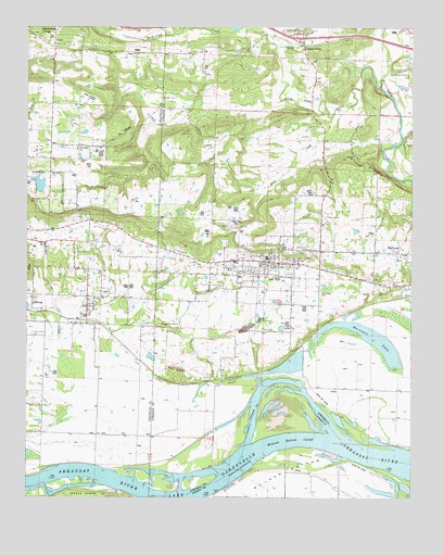
Coal Hill, AR USGS Topographic Map
Click on map above to begin viewing in our Map Viewer.

This topographic map contains these locations and features:
Feature Name Type Latitude Longitude GNIS ID View Map
AlixPopulated PlaceN35.4248°W93.7305°45824View Map
Alix Gas FieldOilfieldN35.4137°W93.7177°62987View Map
Alix Pond (historical)LakeN35.4240°W93.7369°79123View Map
Alix Post OfficePost OfficeN35.4249°W93.7310°84234View Map
Altus Gas FieldOilfieldN35.4654°W93.7427°62988View Map
Assembly of God ChurchChurchN35.4234°W93.7313°79252View Map
Assembly of God ChurchChurchN35.4304°W93.6777°79255View Map
Burnett CemeteryCemeteryN35.4815°W93.7074°47199View Map
Cedar CreekStreamN35.4062°W93.6696°47594View Map
Center PointLocaleN35.4954°W93.6607°47641View Map
Center Point Missionary Baptist ChurchChurchN35.4959°W93.6610°65133View Map
Church of ChristChurchN35.4370°W93.6716°79260View Map
City of Coal HillCivilN35.4368°W93.6659°2404084View Map
Coal HillPopulated PlaceN35.4373°W93.6730°76645View Map
Coal Hill CemeteryCemeteryN35.4359°W93.6824°79256View Map
Coal Hill City ParkParkN35.4329°W93.6669°79262View Map
Coal Hill Gas FieldOilfieldN35.4793°W93.6599°65138View Map
Coal Hill Police DepartmentBuildingN35.4379°W93.6734°2118864View Map
Coal Hill Post OfficePost OfficeN35.4372°W93.6700°2781871View Map
Coal Hill Volunteer Fire DepartmentBuildingN35.4382°W93.6747°2116287View Map
Dirty CreekStreamN35.4843°W93.6357°76800View Map
East Fork Horsehead CreekStreamN35.4704°W93.6282°71505View Map
Ferguson Memorial Presbyterian ChurchChurchN35.4365°W93.6757°79257View Map
First Baptist ChurchChurchN35.4351°W93.6766°79261View Map
Forbus CemeteryCemeteryN35.4959°W93.7421°49151View Map
Free Full Gospel ChurchChurchN35.4368°W93.6688°79258View Map
Greenwood CemeteryCemeteryN35.4187°W93.7482°49670View Map
Hardgraves CemeteryCemeteryN35.4879°W93.6268°49847View Map
Hartman LakeLakeN35.4169°W93.6389°74884View Map
Hess CemeteryCemeteryN35.4501°W93.6524°50033View Map
Houston CemeteryCemeteryN35.4409°W93.7346°50356View Map
Huddleston CemeteryCemeteryN35.4412°W93.6591°50384View Map
Hurst Memorial ParkParkN35.4265°W93.7299°79254View Map
Interchange 47CrossingN35.4981°W93.6613°58984View Map
McKinney CreekStreamN35.4951°W93.6699°72609View Map
McLean Bottom CutoffChannelN35.3895°W93.6644°51864View Map
Methodist ChurchChurchN35.4368°W93.6721°79259View Map
Patsy CreekStreamN35.4773°W93.6485°79263View Map
Philips CemeteryCemeteryN35.4940°W93.7327°53328View Map
Possum Walk CemeteryCemeteryN35.4773°W93.6582°53714View Map
Srygley CemeteryCemeteryN35.4406°W93.6599°55142View Map
Swiss Family Vineyards DamDamN35.4601°W93.7352°79942View Map
Swiss Family Vineyards ReservoirReservoirN35.4601°W93.7352°79943View Map
Township of AlixCivilN35.4243°W93.7264°66542View Map
Township of GrantCivilN35.4253°W93.6752°66753View Map
Township of LeeCivilN35.4852°W93.6686°66759View Map
United Methodist ChurchChurchN35.4254°W93.7305°79253View Map
West CemeteryCemeteryN35.4198°W93.6738°56172View Map
Westside High SchoolSchoolN35.4417°W93.6541°65178View Map
Whippoorwill Church (historical)ChurchN35.4879°W93.6935°79164View Map

Note: Coordinates in the location and feature list above are referenced to NAD83 datum.


Copyright (C) 2008-2025 Ryan Niemi / Sunset Dynamics ... All Rights Reserved