TopoQuest Logo
Do you find TopoQuest useful?
Help keep TopoQuest running and adding new maps/features by donating!
Bitcoin:  19c7KJd3qBynnjoSw5npx9KScwjBe4ifkT
Litecoin:  LXs6TkuXGGXo1vDsWCkWVdjQX94eUKd6ui
Home View Maps Find Maps Find Places Resources & Links


Water Canyon Peak, Utah Topographic Map

USGS Map Title: Water Canyon Peak, UT
USGS Map MRC: 37113E8
DRG (GeoTIFF) Download: o37113e8.tif


Neighboring USGS Topographic Map Quads:


  Uvada, UT  
37114F1
 

  Mount Escalante, UT  
37113F8
 

  Pinon Point, UT  
37113F7
 

  Pine Park, UT  
37114E1
 

  Water Canyon Peak, UT  
37113E8
 

  Hebron, UT  
37113E7
 

  Docs Pass, NV  
37114D1
 

  Goldstrike, UT  
37113D8
 

  Maple Ridge, UT  
37113D7


Map MRC Location:

N38°
W114°
N38°
W113°
H8 H7 H6 H5 H4 H3 H2 H1
G8 G7 G6 G5 G4 G3 G2 G1
F8 F7 F6 F5 F4 F3 F2 F1
E8 E7 E6 E5 E4 E3 E2 E1
D8 D7 D6 D5 D4 D3 D2 D1
C8 C7 C6 C5 C4 C3 C2 C1
B8 B7 B6 B5 B4 B3 B2 B1
A8 A7 A6 A5 A4 A3 A2 A1
N37°
W114°
N37°
W113°

Water Canyon Peak, UT USGS 1:24K Topographic Map Preview:
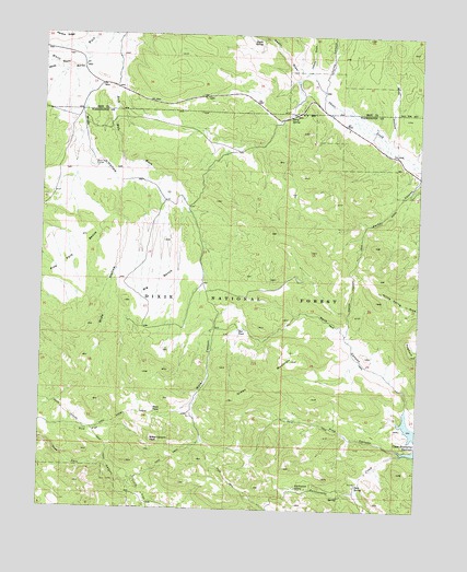
Water Canyon Peak, UT USGS Topographic Map
Click on map above to begin viewing in our Map Viewer.

This topographic map contains these locations and features:
Feature Name Type Latitude Longitude GNIS ID View Map
Big BenchBenchN37.5589°W113.9639°1438635View Map
Colie FlatFlatN37.5041°W113.9680°1439892View Map
Crestline DrawValleyN37.6189°W113.9997°1440155View Map
Dads SpringSpringN37.5068°W113.8953°1440224View Map
Green MountainSummitN37.5394°W113.9175°1441475View Map
HogbackRidgeN37.5414°W113.8778°1441799View Map
Horse CanyonValleyN37.6139°W113.9075°1441861View Map
Indian DrawValleyN37.6164°W113.9130°1441996View Map
Jessie Tie WashValleyN37.6175°W113.9994°1438087View Map
Mud FlatFlatN37.5222°W113.9841°1443662View Map
Nephi DrawValleyN37.6166°W113.9169°1443796View Map
Nephi SpringSpringN37.6239°W113.9297°1443798View Map
Parker CanyonValleyN37.5872°W113.8764°1444211View Map
Parker Canyon TrailTrailN37.5669°W113.8958°1444213View Map
Pine CanyonValleyN37.5161°W113.8822°1444358View Map
Pine Park BenchBenchN37.5728°W113.9858°1444398View Map
Rattlesnake CreekStreamN37.5150°W113.8811°1444736View Map
Rattlesnake SpringSpringN37.5060°W113.9151°1444731View Map
Red PondLakeN37.5474°W113.9352°1444830View Map
Rock CanyonValleyN37.5269°W113.8794°1445030View Map
Rock Hole CorralLocaleN37.5911°W113.9836°1445069View Map
Rock Hole WashValleyN37.6233°W113.9766°1445070View Map
Terry SpringSpringN37.6038°W113.9191°1446402View Map
Water CanyonValleyN37.5486°W113.9433°1447033View Map
Water Canyon PeakSummitN37.5183°W113.9636°1447043View Map
West PassGapN37.5264°W113.9630°1447171View Map
White Hollow Pack TrailTrailN37.5261°W113.9933°1447253View Map
Wide HollowValleyN37.6128°W113.9866°1447309View Map
Wide HollowValleyN37.5983°W113.8853°1447317View Map

Note: Coordinates in the location and feature list above are referenced to NAD83 datum.


Copyright (C) 2008-2025 Ryan Niemi / Sunset Dynamics ... All Rights Reserved